Chardon is a city in and the county seat of Geauga County, Ohio, United States. The population was 5,242 at the 2020 census. It is the only incorporated city in Geauga County, and includes land that was once part of Chardon, Hambden and Munson townships. It is located about 10 miles south of Lake Erie and within the “snow belt” of the Great Lakes and is part of the Cleveland metropolitan area.
| Name: | Chardon city |
|---|---|
| LSAD Code: | 25 |
| LSAD Description: | city (suffix) |
| State: | Ohio |
| County: | Geauga County |
| Elevation: | 1,299 ft (396 m) |
| Total Area: | 4.42 sq mi (11.46 km²) |
| Land Area: | 4.39 sq mi (11.37 km²) |
| Water Area: | 0.03 sq mi (0.09 km²) |
| Total Population: | 5,242 |
| Population Density: | 1,193.81/sq mi (460.93/km²) |
| ZIP code: | 44024 |
| Area code: | 440 |
| FIPS code: | 3913554 |
| GNISfeature ID: | 1056789 |
| Website: | Chardon.cc |
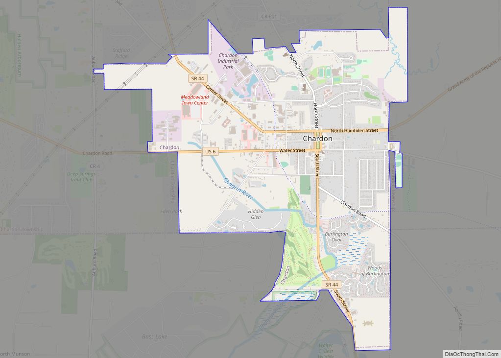
Online Interactive Map
Click on ![]() to view map in "full screen" mode.
to view map in "full screen" mode.
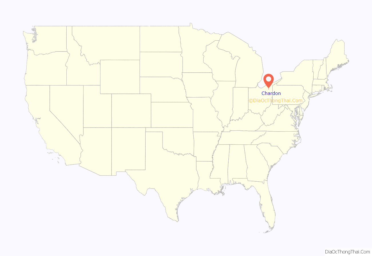
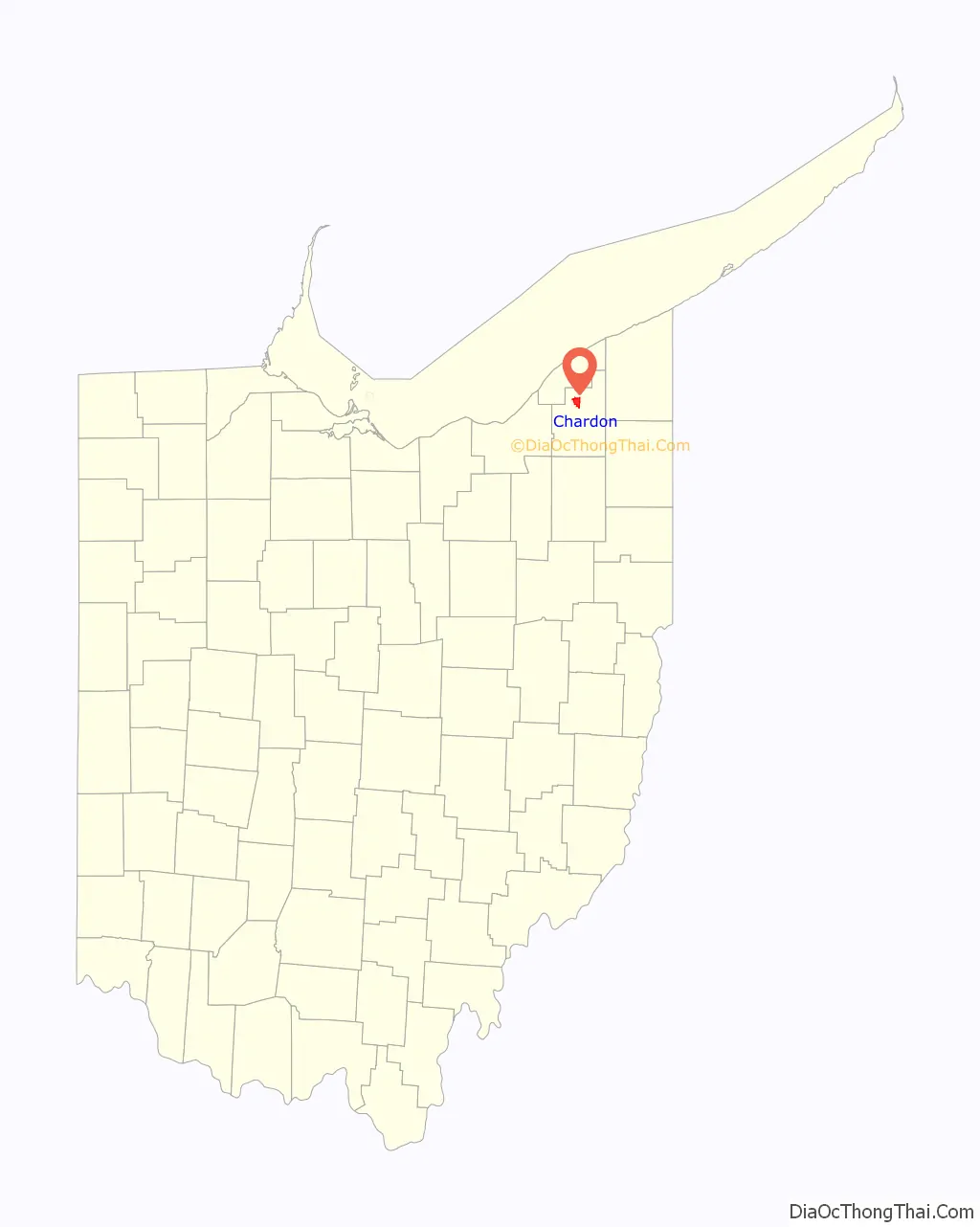
Chardon location map. Where is Chardon city?
History
Chardon is named after Peter Chardon Brooks, who donated land to build the historic Chardon Square. Chardon Township celebrates its incorporation in 1812, and thus the City of Chardon does the same.
On July 24–25, 1868, a massive fire totally destroyed the center of uptown, the area now known as Chardon Square. The fire originated in the Parlin Parkin’s grocery store, and spread rapidly. By the time the fire was contained, the courthouse, post office, and many stores on the square were destroyed. Damage was estimated at around $120,000. Chardon Square was quickly rebuilt following the fire. A new county courthouse, which still stands today, was completed in 1869. Many other buildings that were constructed after the fire also survive and are used today.
School shooting
On February 27, 2012, a student from Lake Academy in Willoughby, Ohio opened fire at the Chardon High School cafeteria, killing three and injuring two students. Daniel Parmertor, 16 years old, was killed at the time of the shooting. Two other victims, Demetrius Hewlin and Russell King, Jr., were pronounced dead on February 28. The shooter was taken into custody by police and was charged with three counts of aggravated murder. He was sentenced to three consecutive life terms in prison without parole.
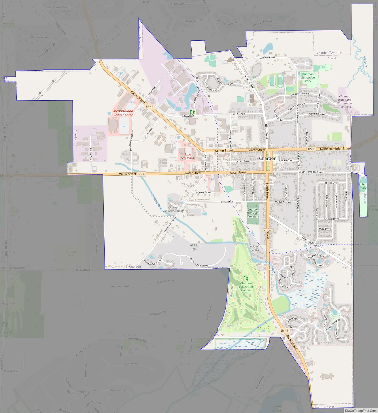
Chardon Road Map
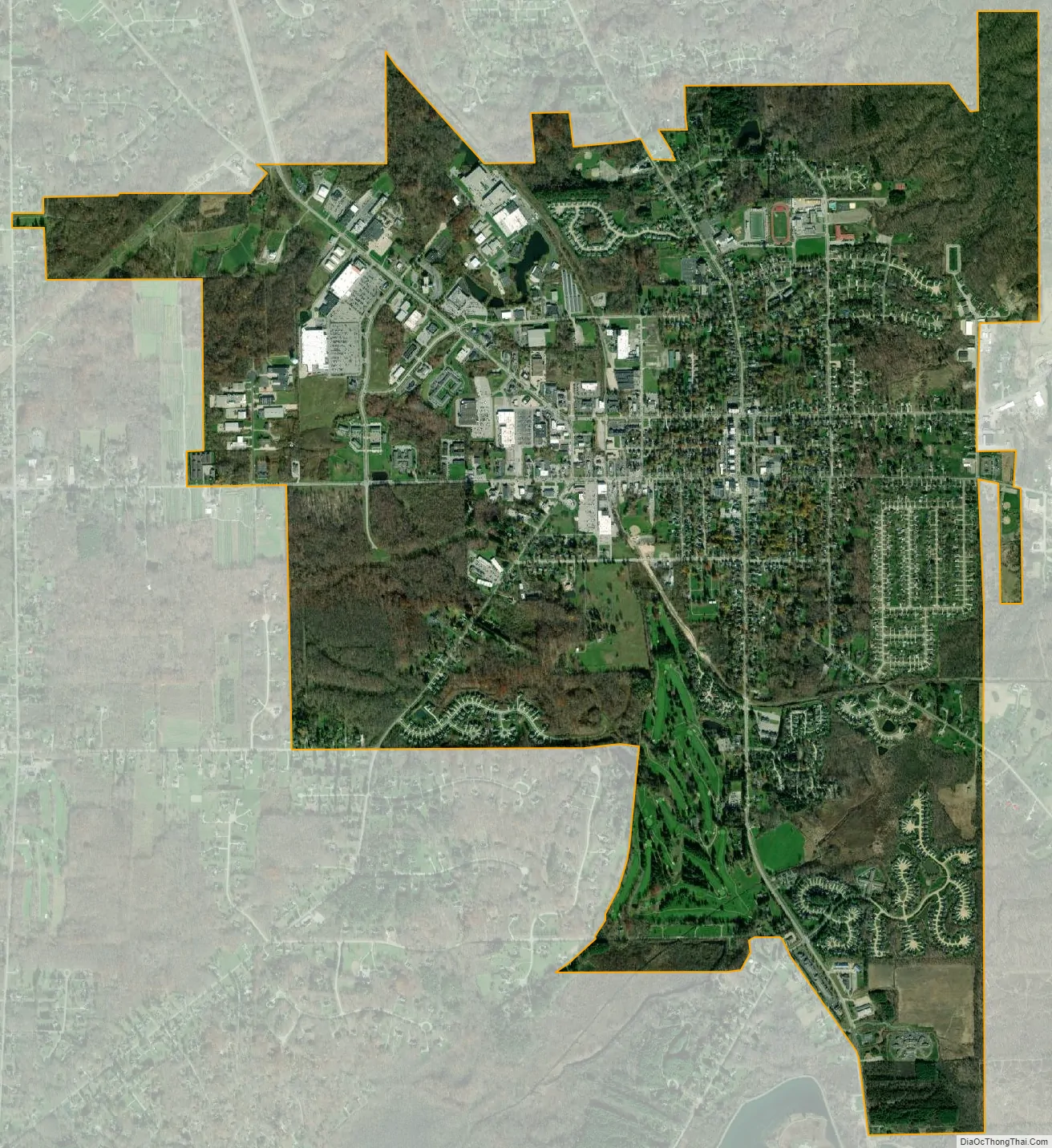
Chardon city Satellite Map
Geography
Chardon is located on U.S. Route 6 about 15 miles (24 km) east of Cleveland. According to the United States Census Bureau, the city has a total area of 4.62 square miles (11.97 km), of which 4.58 square miles (11.86 km) is land and 0.04 square miles (0.10 km) or about 25 acres (10 ha) is water.
Climate
With an average annual snowfall of 107 inches (272 cm), Chardon is notable for being the snowiest city in Ohio. This is mainly due to its location on a 730-foot (223 m) ridge approximately 10 miles (16 km) inland from Lake Erie, creating the perfect conditions for orographic lift and its associated heavy snowfall when winter winds blow across the lake.
In 1996, from November 9 through November 13, a storm dropped over 70 inches (178 cm) of lake-effect snow in the city over a period of six days. Governor George Voinovich declared a state of emergency as a result, and the Ohio National Guard was brought in to assist with the cleanup.
Chardon has a humid continental climate (Dfb). Summer days are warm to hot while nights remain cool. Summer is also the rainiest time of the year. Winters are moderately long, cold, and very snowy. Precipitation peaks during the month of August.
See also
Map of Ohio State and its subdivision:- Adams
- Allen
- Ashland
- Ashtabula
- Athens
- Auglaize
- Belmont
- Brown
- Butler
- Carroll
- Champaign
- Clark
- Clermont
- Clinton
- Columbiana
- Coshocton
- Crawford
- Cuyahoga
- Darke
- Defiance
- Delaware
- Erie
- Fairfield
- Fayette
- Franklin
- Fulton
- Gallia
- Geauga
- Greene
- Guernsey
- Hamilton
- Hancock
- Hardin
- Harrison
- Henry
- Highland
- Hocking
- Holmes
- Huron
- Jackson
- Jefferson
- Knox
- Lake
- Lake Erie
- Lawrence
- Licking
- Logan
- Lorain
- Lucas
- Madison
- Mahoning
- Marion
- Medina
- Meigs
- Mercer
- Miami
- Monroe
- Montgomery
- Morgan
- Morrow
- Muskingum
- Noble
- Ottawa
- Paulding
- Perry
- Pickaway
- Pike
- Portage
- Preble
- Putnam
- Richland
- Ross
- Sandusky
- Scioto
- Seneca
- Shelby
- Stark
- Summit
- Trumbull
- Tuscarawas
- Union
- Van Wert
- Vinton
- Warren
- Washington
- Wayne
- Williams
- Wood
- Wyandot
- Alabama
- Alaska
- Arizona
- Arkansas
- California
- Colorado
- Connecticut
- Delaware
- District of Columbia
- Florida
- Georgia
- Hawaii
- Idaho
- Illinois
- Indiana
- Iowa
- Kansas
- Kentucky
- Louisiana
- Maine
- Maryland
- Massachusetts
- Michigan
- Minnesota
- Mississippi
- Missouri
- Montana
- Nebraska
- Nevada
- New Hampshire
- New Jersey
- New Mexico
- New York
- North Carolina
- North Dakota
- Ohio
- Oklahoma
- Oregon
- Pennsylvania
- Rhode Island
- South Carolina
- South Dakota
- Tennessee
- Texas
- Utah
- Vermont
- Virginia
- Washington
- West Virginia
- Wisconsin
- Wyoming