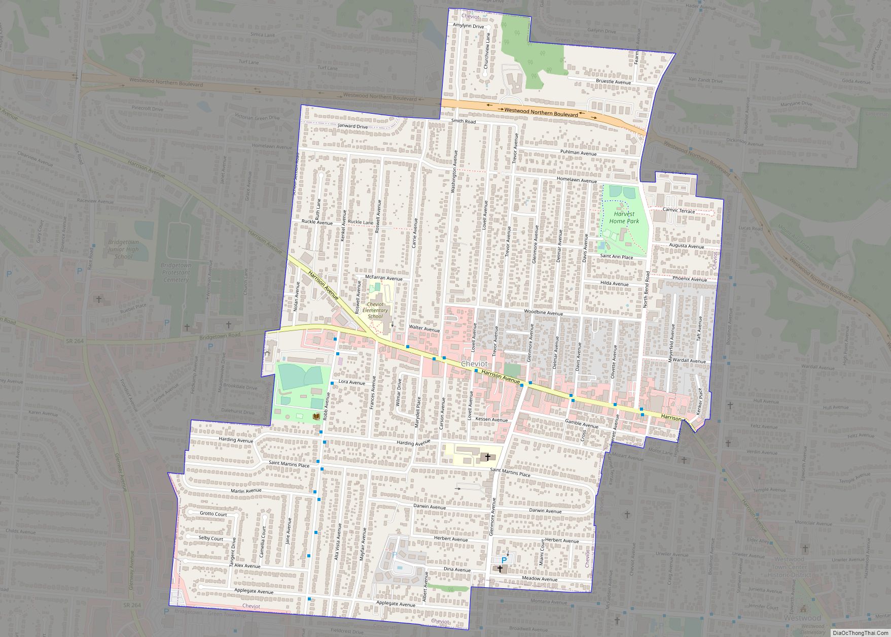
Map of Chatfield village, Ohio

Map of Chatfield village, Ohio

Chatfield is a village in Crawford County, Ohio, United States. The population was 189 at the 2010 census. Chatfield village overview: Name: Chatfield village LSAD Code: 47 LSAD Description: village (suffix) State: Ohio County: Crawford County Elevation: 981 ft (299 m) Total Area: 0.29 sq mi (0.76 km²) Land Area: 0.29 sq mi (0.76 km²) Water Area: 0.00 sq mi (0.00 km²) Total Population: 205 Population … Read more

Map of Chippewa Park CDP

Map of Chippewa Park CDP

Chippewa Park is a census-designated place in Stokes Township, Logan County, Ohio, United States. As of the 2010 census, the population was 891. Chippewa Park CDP overview: Name: Chippewa Park CDP LSAD Code: 57 LSAD Description: CDP (suffix) State: Ohio County: Logan County Elevation: 1,015 ft (309 m) Total Area: 0.49 sq mi (1.28 km²) Land Area: 0.44 sq mi (1.14 km²) Water … Read more

Map of Chippewa Lake village

Map of Chippewa Lake village

Chippewa Lake (formerly Chippewa-on-the-Lake) is a village in Medina County, Ohio, United States. It is located on Chippewa Lake, a natural inland lake in Ohio. The village was incorporated in 1920. The population was 711 at the 2010 census. Chippewa Lake village overview: Name: Chippewa Lake village LSAD Code: 47 LSAD Description: village (suffix) State: … Read more

Map of Chilo village

Map of Chilo village

Chilo /ˈʃaɪloʊ/ or /ˈtʃaɪloʊ/ is a village in Clermont County, Ohio, United States, along the Ohio River. The population was 71 at the 2020 census. Chilo village overview: Name: Chilo village LSAD Code: 47 LSAD Description: village (suffix) State: Ohio County: Clermont County Elevation: 499 ft (152 m) Total Area: 0.24 sq mi (0.63 km²) Land Area: 0.20 sq mi (0.52 km²) Water … Read more

Map of Chillicothe city, Ohio

Map of Chillicothe city, Ohio

Chillicothe (/ˌtʃɪlɪˈkɒθi/ CHIL-ih-KOTH-ee) is a city in and the county seat of Ross County, Ohio, United States. Located along the Scioto River 45 miles (72 km) south of Columbus, Chillicothe was the first and third capital of Ohio. It is the only city in Ross County and is the center of the Chillicothe micropolitan area. The … Read more

Map of Chickasaw village, Ohio

Map of Chickasaw village, Ohio

Chickasaw is a village in Mercer County, Ohio, United States. The population was 290 at the 2010 census. Chickasaw village overview: Name: Chickasaw village LSAD Code: 47 LSAD Description: village (suffix) State: Ohio County: Mercer County Elevation: 942 ft (287 m) Total Area: 0.24 sq mi (0.62 km²) Land Area: 0.24 sq mi (0.62 km²) Water Area: 0.00 sq mi (0.00 km²) Total Population: 358 Population … Read more

Map of Circleville city, Ohio

Map of Circleville city, Ohio

Circleville is a city in, and the county seat of, Pickaway County, Ohio, United States. The city is situated along the Scioto River, 25 miles (40 km) south of Columbus. The population was recorded to be 13,927 in the 2020 census. Circleville is best-known today as the host of the Circleville Pumpkin Show, an annual festival … Read more

Map of Cinnamon Lake CDP

Map of Cinnamon Lake CDP

Cinnamon Lake is a census-designated place (CDP) within Jackson Township, Ashland County, Ohio, United States. The population was 1,237 at the 2020 census. It consists of a planned community surrounding a 135-acre (0.55 km) reservoir also named Cinnamon Lake. Cinnamon Lake CDP overview: Name: Cinnamon Lake CDP LSAD Code: 57 LSAD Description: CDP (suffix) State: Ohio … Read more

Map of Churchill CDP, Ohio

Map of Churchill CDP, Ohio

Churchill is a census-designated place in Liberty Township, Trumbull County, Ohio, United States. The population was 2,176 at the 2020 census. It is part of Youngstown–Warren metropolitan area. The community was named for a hilltop church near the original townsite. Churchill CDP overview: Name: Churchill CDP LSAD Code: 57 LSAD Description: CDP (suffix) State: Ohio … Read more

Map of Christiansburg village

Map of Christiansburg village, Ohio

Christiansburg is a village in Champaign County, Ohio, United States. The population was 526 at the 2010 census. Christiansburg village overview: Name: Christiansburg village LSAD Code: 47 LSAD Description: village (suffix) State: Ohio County: Champaign County Elevation: 1,115 ft (340 m) Total Area: 0.24 sq mi (0.62 km²) Land Area: 0.24 sq mi (0.62 km²) Water Area: 0.00 sq mi (0.00 km²) Total Population: 505 Population … Read more

Map of Choctaw Lake CDP

Map of Choctaw Lake CDP

Choctaw Lake is a census-designated place (CDP) in Madison County, Ohio, United States. The population was 1,562 at the 2000 census. Choctaw Lake CDP overview: Name: Choctaw Lake CDP LSAD Code: 57 LSAD Description: CDP (suffix) State: Ohio County: Madison County Elevation: 1,040 ft (317 m) Total Area: 1.44 sq mi (3.74 km²) Land Area: 1.04 sq mi (2.69 km²) Water Area: 0.41 sq mi … Read more

Map of Clinton village, Ohio

Map of Clinton village, Ohio

Clinton is a village in southwestern Summit County, Ohio, United States. The population was 1,197 at the 2020 Census. It is part of the Akron metropolitan area. Clinton village overview: Name: Clinton village LSAD Code: 47 LSAD Description: village (suffix) State: Ohio County: Summit County Elevation: 948 ft (289 m) Total Area: 3.68 sq mi (9.52 km²) Land Area: 3.59 sq mi … Read more