Map of Addyston village

Map of Addyston village

Addyston is a village in Miami Township, Hamilton County, Ohio, United States, along the Ohio River. The population was 927 at the 2020 census. The village was named after Matthew Addy, the proprietor of a local factory. Addyston village overview: Name: Addyston village LSAD Code: 47 LSAD Description: village (suffix) State: Ohio County: Hamilton County … Read more

Map of Adamsville village, Ohio

Map of Adamsville village, Ohio

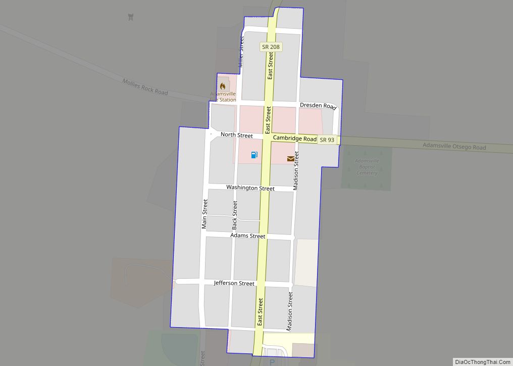
Adamsville is a village in Muskingum County, Ohio, United States. The population was 140 at the 2020 census. It is part of the Zanesville micropolitan area. Adamsville village overview: Name: Adamsville village LSAD Code: 47 LSAD Description: village (suffix) State: Ohio County: Muskingum County Elevation: 1,020 ft (310 m) Total Area: 0.05 sq mi (0.14 km²) Land Area: 0.05 sq mi (0.14 km²) … Read more

Map of Ada village, Ohio

Map of Ada village, Ohio

Ada /ˈeɪdə/; AY-də; is a village in Hardin County, Ohio, United States, located about 69 miles (111 km) southwest of Toledo. The population was 5,952 at the 2010 census. Ada village overview: Name: Ada village LSAD Code: 47 LSAD Description: village (suffix) State: Ohio County: Hardin County Elevation: 958 ft (292 m) Total Area: 2.13 sq mi (5.53 km²) Land Area: … Read more

Map of Amherst city, Ohio

Map of Amherst city, Ohio

Amherst (/ˈæmhərst/) is a city in Lorain County, Ohio, United States. It is located 28 miles (45 km) west of Cleveland within the Cleveland metropolitan area. The population was 12,681 at the 2020 census. Amherst city overview: Name: Amherst city LSAD Code: 25 LSAD Description: city (suffix) State: Ohio County: Lorain County Elevation: 689 ft (210 m) Total … Read more

Map of Amesville village

Map of Amesville village

Amesville /ˈeɪmzvɪl/ is a village in Athens County, Ohio, United States, located on Federal Creek. The population was 171 at the 2020 census. Amesville village overview: Name: Amesville village LSAD Code: 47 LSAD Description: village (suffix) State: Ohio County: Athens County Elevation: 633 ft (193 m) Total Area: 0.23 sq mi (0.60 km²) Land Area: 0.23 sq mi (0.59 km²) Water Area: 0.00 sq mi … Read more

Map of Amelia village, Ohio

Map of Amelia village, Ohio

Amelia is an unincorporated community and former village in Pierce and Batavia townships in Clermont County, Ohio, United States. The population was 12,575 at the 2020 census. Amelia incorporated in 1900. In November 2019, residents voted to dissolve the village over the imposition of a local income tax. Amelia was by far the most populous … Read more

Map of Amberley village

Map of Amberley village

Amberley, locally known as Amberley Village, is a village in Hamilton County, Ohio, United States. The population was 3,840 at the 2020 census. Amberley village overview: Name: Amberley village LSAD Code: 47 LSAD Description: village (suffix) State: Ohio County: Hamilton County Elevation: 797 ft (243 m) Total Area: 3.48 sq mi (9.02 km²) Land Area: 3.48 sq mi (9.02 km²) Water Area: 0.00 sq mi … Read more

Map of Amanda village

Map of Amanda village

Amanda is a village in Fairfield County, Ohio, United States. The population was 737 at the 2010 census. Amanda was the birthplace of Thomas Sterling, a Republican in the United States Senate from 1913 to 1925. Amanda village overview: Name: Amanda village LSAD Code: 47 LSAD Description: village (suffix) State: Ohio County: Fairfield County Elevation: … Read more

Map of Alvordton CDP

Map of Alvordton CDP

Alvordton is a census-designated place in central Mill Creek Township, Williams County, Ohio, United States. The population was 305 at the 2000 census, at which time it was a village. In 2010, the U.S. Census Bureau listed Alvordton as a census-designated place. Alvordton CDP overview: Name: Alvordton CDP LSAD Code: 57 LSAD Description: CDP (suffix) … Read more

Map of Alliance city, Ohio

Map of Alliance city, Ohio

Alliance is a city in eastern Stark County, Ohio, United States. With a small district lying in adjacent Mahoning County, the city is approximately 16 miles (26 km) northeast of Canton, 27 miles (43 km) southwest of Youngstown and 51 miles (82 km) southeast of Cleveland. The population was 21,672 as of the 2020 census. Alliance was established … Read more

Map of Alger village

Map of Alger village, Ohio

Alger (/ˈældʒər/ AL-jər) is a village in Hardin County, Ohio, United States. The population was 860 at the 2010 census. Alger village overview: Name: Alger village LSAD Code: 47 LSAD Description: village (suffix) State: Ohio County: Hardin County Elevation: 978 ft (298 m) Total Area: 0.30 sq mi (0.77 km²) Land Area: 0.30 sq mi (0.77 km²) Water Area: 0.00 sq mi (0.00 km²) Total Population: … Read more

Map of Alexandria village, Ohio

Map of Alexandria village, Ohio

Alexandria is a village in Licking County, Ohio, United States. The population was 517 at the 2010 census and an estimated 542 in 2019. Alexandria was laid out in 1830. Village voters defeated a ballot issue to dissolve the village and become a part of St. Albans Township. The vote was 92% against the dissolution … Read more