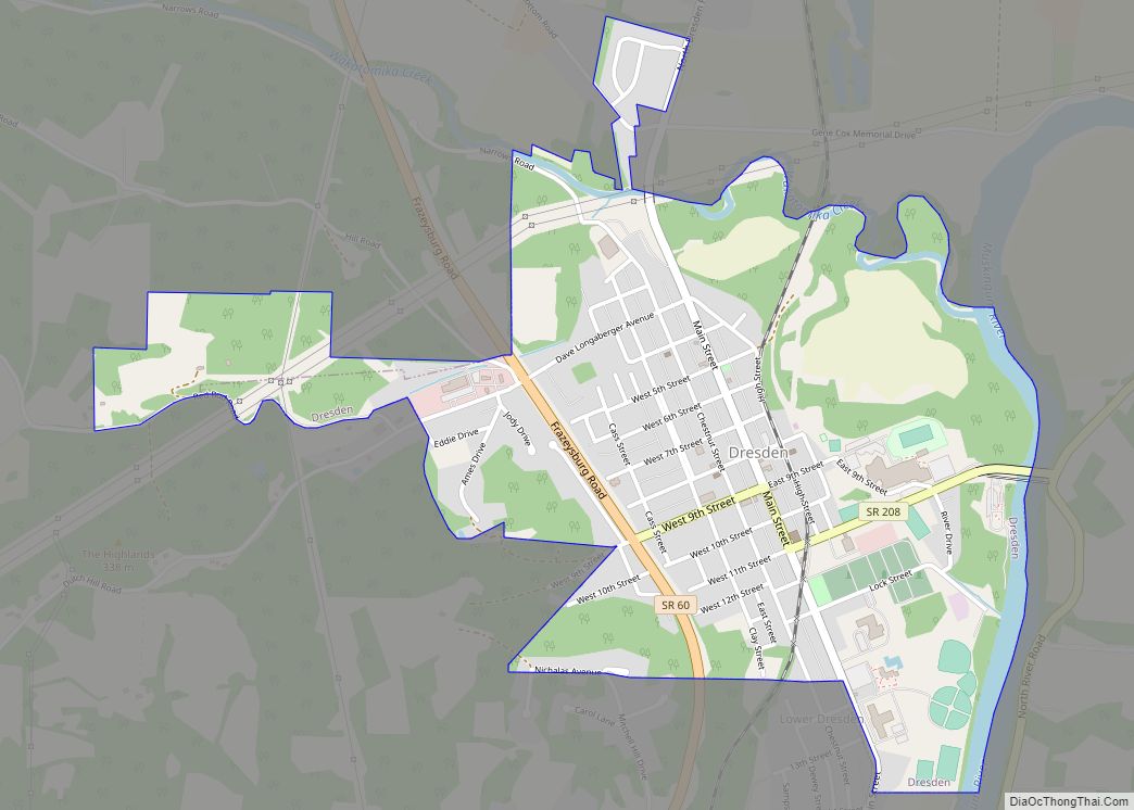
Dresden is a village in Muskingum County, Ohio, United States, along the Muskingum River at the mouth of Wakatomika Creek. The population was 1,650 at the 2020 census. It is part of the Zanesville micropolitan area. It was incorporated on March 9, 1835. Dresden village overview: Name: Dresden village LSAD Code: 47 LSAD Description: village ... Read more
Ohio Cities and Places
Doylestown is a village located atop the highest point in Wayne County, Ohio, United States, 13 miles (21 km) southwest of Akron. The population was 3,051 at the 2010 census. Doylestown village overview: Name: Doylestown village LSAD Code: 47 LSAD Description: village (suffix) State: Ohio County: Wayne County Elevation: 1,250 ft (381 m) Total Area: 1.86 sq mi (4.82 km²) Land ... Read more
Dover is a city in Tuscarawas County, Ohio, United States, along the Tuscarawas River. The population was 13,112 at the 2020 census. It is a principal city of the New Philadelphia–Dover micropolitan area, approximately 68 miles (109 km) south of Cleveland. Dover city overview: Name: Dover city LSAD Code: 25 LSAD Description: city (suffix) State: Ohio ... Read more
Donnelsville is a village in Clark County, Ohio, United States. The population was 304 at the 2010 census. It is part of the Springfield, Ohio Metropolitan Statistical Area. Donnelsville village overview: Name: Donnelsville village LSAD Code: 47 LSAD Description: village (suffix) State: Ohio County: Clark County Elevation: 932 ft (284 m) Total Area: 0.32 sq mi (0.82 km²) Land Area: ... Read more
Dola is a census-designated place in central Washington Township, Hardin County, Ohio, United States. As of the 2010 United States Census it had a population of 140. It has a post office with the ZIP code 45835. Dola CDP overview: Name: Dola CDP LSAD Code: 57 LSAD Description: CDP (suffix) State: Ohio County: Hardin County ... Read more
Dillonvale is a census-designated place (CDP) in Sycamore Township, Hamilton County, Ohio, United States. The population was 3,436 at the 2020 census. Dillonvale CDP overview: Name: Dillonvale CDP LSAD Code: 57 LSAD Description: CDP (suffix) State: Ohio County: Hamilton County Elevation: 784 ft (239 m) Total Area: 0.89 sq mi (2.31 km²) Land Area: 0.89 sq mi (2.31 km²) Water Area: 0.00 sq mi (0.00 km²) ... Read more
Dexter City is a village in Noble County, Ohio, United States, along the West Fork of Duck Creek. The population was 81 at the 2020 census. Dexter City was laid out in 1870, and named after Dexter W. Sullivan, an early settler. Dexter City village overview: Name: Dexter City village LSAD Code: 47 LSAD Description: ... Read more
Dupont is a village in Putnam County, Ohio, United States. The population was 318 at the 2010 census. Dupont village overview: Name: Dupont village LSAD Code: 47 LSAD Description: village (suffix) State: Ohio County: Putnam County Elevation: 725 ft (221 m) Total Area: 0.92 sq mi (2.37 km²) Land Area: 0.91 sq mi (2.36 km²) Water Area: 0.00 sq mi (0.01 km²) Total Population: 212 Population ... Read more
Dunlap is a census-designated place (CDP) in Colerain Township, Hamilton County, Ohio, United States. The population was 1,658 at the 2020 census. The siege of Dunlap’s Station was a battle that took place near here on the Great Miami in 1791 during the Northwest Indian War. Dunlap CDP overview: Name: Dunlap CDP LSAD Code: 57 ... Read more
Dunkirk is a village in Hardin County, Ohio, United States. The population was 875 at the 2010 census. Dunkirk village overview: Name: Dunkirk village LSAD Code: 47 LSAD Description: village (suffix) State: Ohio County: Hardin County Elevation: 945 ft (288 m) Total Area: 0.72 sq mi (1.86 km²) Land Area: 0.66 sq mi (1.70 km²) Water Area: 0.06 sq mi (0.15 km²) Total Population: 774 Population ... Read more
Dundee is a census-designated place in central Wayne Township, Tuscarawas County, Ohio, United States. It has a post office with the ZIP code 44624. It lies at the intersection of State Routes 93 and 516. Dundee CDP overview: Name: Dundee CDP LSAD Code: 57 LSAD Description: CDP (suffix) State: Ohio County: Tuscarawas County FIPS code: ... Read more
Duncan Falls is a census-designated place in southeastern Wayne Township, Muskingum County, Ohio, United States, located on State Route 60 south of the city of Zanesville. It has a post office with the ZIP code 43734. Duncan Falls has a public library, a branch of the Muskingum County Library System. Duncan Falls CDP overview: Name: ... Read more