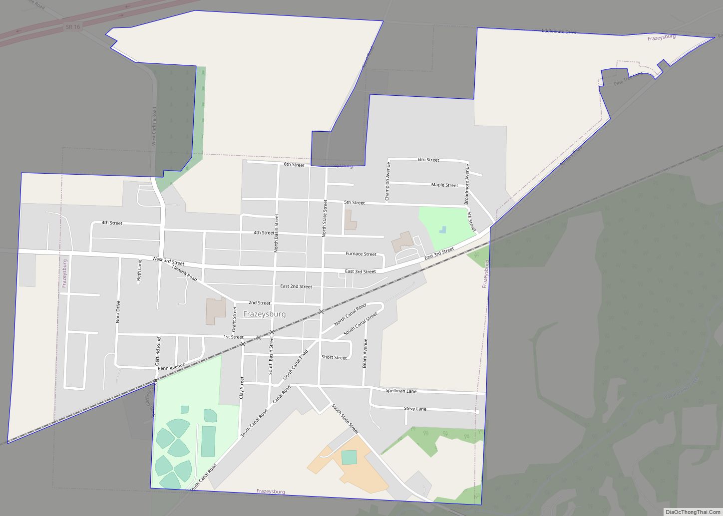
Map of Frankfort village, Ohio

Map of Frankfort village, Ohio

Frankfort is a village in Ross County, Ohio, United States, along the North Fork of Paint Creek. The village is located in Concord Township. The population was 1,064 at the 2010 census. Frankfort village overview: Name: Frankfort village LSAD Code: 47 LSAD Description: village (suffix) State: Ohio County: Ross County Elevation: 738 ft (225 m) Total Area: … Read more

Map of Four Bridges CDP

Map of Four Bridges CDP

Four Bridges is a census-designated place (CDP) in Liberty Township, Butler County, Ohio, United States. The population was 2,919 at the 2010 census. Four Bridges CDP overview: Name: Four Bridges CDP LSAD Code: 57 LSAD Description: CDP (suffix) State: Ohio County: Butler County Elevation: 850 ft (260 m) Total Area: 2.20 sq mi (5.69 km²) Land Area: 2.19 sq mi (5.68 km²) Water … Read more

Map of Fostoria city, Ohio

Map of Fostoria city, Ohio

Fostoria (/fɒsˈtʊəriːə/, foss-TORR-EE-ə) is a city located at the convergence of Hancock, Seneca, and Wood counties in the northwestern part of the U.S. state of Ohio. It is approximately 40 miles (64 km) south of Toledo and 90 miles (140 km) north of Columbus. The city is known for its railroads, as approximately 100 trains pass through … Read more

Map of Fort Shawnee CDP

Map of Fort Shawnee CDP

Fort Shawnee is census-designated place (CDP) in Allen County, Ohio, United States. The population was 6,263 at the 2020 census. It is included in the Lima, Ohio Metropolitan Statistical Area. Fort Shawnee is adjacent to the city of Lima and the village of Cridersville in Auglaize County. In 2012, village residents voted to disincorporate the … Read more

Map of Fort Seneca CDP

Map of Fort Seneca CDP

Fort Seneca is a census-designated place in Pleasant Township, Seneca County, Ohio, United States. It is located on State Route 53, approximately 6 miles (9.7 km) North of Tiffin. It had a population of 254 in 2010. Although unincorporated, Fort Seneca had a post office, with the ZIP code of 44829 until 1998. The post office … Read more

Map of Fulton village, Ohio

Map of Fulton village, Ohio

Fulton is a village in Morrow County, Ohio, United States. The population was 258 at the 2010 census. Fulton is south of Mount Gilead, the county seat. Fulton village overview: Name: Fulton village LSAD Code: 47 LSAD Description: village (suffix) State: Ohio County: Morrow County Elevation: 1,109 ft (338 m) Total Area: 0.16 sq mi (0.42 km²) Land Area: 0.16 sq mi … Read more

Map of Fruit Hill CDP

Map of Fruit Hill CDP

Fruit Hill is a census-designated place (CDP) in Hamilton County, Ohio, United States. The population was 3,748 at the 2020 census. Fruit Hill is located at 39°4′15″N 84°21′53″W / 39.07083°N 84.36472°W / 39.07083; -84.36472 (39.070912, -84.364707). According to the United States Census Bureau, the CDP has a total area of 1.3 square miles (3.3 km), all … Read more

Map of Friendship CDP, Ohio

Map of Friendship CDP, Ohio

Friendship is a census-designated place in western Nile Township, Scioto County, Ohio, United States. As of the 2010 census it had a population of 351. It has a post office with the ZIP code 45630. It lies along U.S. Route 52. The citizens of Friendship are served by the Nile Township Volunteer Fire Department and … Read more

Map of Fresno CDP, Ohio

Map of Fresno CDP, Ohio

Fresno is a census-designated place in eastern White Eyes Township, Coshocton County, Ohio, United States. As of the 2010 census it had a population of 140. It has a post office with the ZIP code 43824, gas station, White Eyes Carryout/Drive Thru and Pizza Shop. It lies along State Route 93 between West Lafayette and … Read more

Map of Fremont city, Ohio

Map of Fremont city, Ohio

Fremont is a city in and the county seat of Sandusky County, Ohio, United States, located along the banks of the Sandusky River. It is about 35 miles (56 km) from Toledo and 25 miles (40 km) from Sandusky. It is part of the Toledo metropolitan area. The population was 15,930 at the 2020 census. The city … Read more

Map of Freeport village, Ohio

Map of Freeport village, Ohio

Freeport is a village in southwestern Harrison County, Ohio, United States. The population was 321 at the 2020 census. Freeport village overview: Name: Freeport village LSAD Code: 47 LSAD Description: village (suffix) State: Ohio County: Harrison County Elevation: 997 ft (304 m) Total Area: 0.60 sq mi (1.55 km²) Land Area: 0.60 sq mi (1.55 km²) Water Area: 0.00 sq mi (0.00 km²) Total Population: 321 … Read more

Map of Fredericktown village, Ohio

Map of Fredericktown village, Ohio

Fredericktown is a village in Knox County, Ohio, United States. The population was 2,493 at the 2010 census. Fredericktown village overview: Name: Fredericktown village LSAD Code: 47 LSAD Description: village (suffix) State: Ohio County: Knox County Elevation: 1,090 ft (332.2 m) Total Area: 2.08 sq mi (5.38 km²) Land Area: 1.98 sq mi (5.14 km²) Water Area: 0.09 sq mi (0.24 km²) Total Population: 2,648 Population … Read more