Map of Granville village, Ohio

Map of Granville village, Ohio

Granville is a village in Licking County, Ohio, United States. The population was 5,646 at the 2010 census. The village is located in a rural area of rolling hills in central Ohio. It is 35 miles (56 km) east of Columbus, the state capital, and 7 miles (11 km) west of Newark, the county seat. Granville is … Read more

Map of Granville South CDP

Map of Granville South CDP

Granville South is a census-designated place (CDP) in Licking County, Ohio, United States. The population was 1,410 at the 2010 census, up from 1,194 at the 2000 census. Granville South CDP overview: Name: Granville South CDP LSAD Code: 57 LSAD Description: CDP (suffix) State: Ohio County: Licking County Elevation: 1,050 ft (320 m) Total Area: 6.14 sq mi (15.90 km²) … Read more

Map of Grandview CDP, Ohio

Map of Grandview CDP, Ohio

Grandview is a census-designated place (CDP) in Hamilton County, Ohio, United States. The population was 1,312 at the 2020 census. Grandview CDP overview: Name: Grandview CDP LSAD Code: 57 LSAD Description: CDP (suffix) State: Ohio County: Hamilton County Total Area: 4.64 sq mi (12.02 km²) Land Area: 4.34 sq mi (11.25 km²) Water Area: 0.30 sq mi (0.77 km²) Total Population: 1,312 Population Density: … Read more

Map of Grandview Heights city

Map of Grandview Heights city

Grandview Heights, or simply Grandview, is a city in Franklin County, Ohio, United States. The population was 8,085 at the 2020 census. The city was originally part of Marble Cliff, one of the first suburbs of Columbus, which settled as a community in 1890 and incorporated as the “Hamlet of Marble Cliff” in 1901. Grandview … Read more

Map of Grand River village, Ohio

Map of Grand River village, Ohio

Grand River is a village in Lake County, Ohio, United States, along the Grand River. The population was 394 at the 2020 census. Grand River village overview: Name: Grand River village LSAD Code: 47 LSAD Description: village (suffix) State: Ohio County: Lake County Elevation: 610 ft (186 m) Total Area: 0.64 sq mi (1.65 km²) Land Area: 0.59 sq mi (1.52 km²) Water … Read more

Map of Grand Rapids village, Ohio

Map of Grand Rapids village, Ohio

Grand Rapids is a village in Grand Rapids Township, Wood County, Ohio, United States, along the Maumee River. The population was 965 at the 2010 census. Grand Rapids is served by a branch of the Weston Public Library. Grand Rapids village overview: Name: Grand Rapids village LSAD Code: 47 LSAD Description: village (suffix) State: Ohio … Read more

Map of Grafton village, Ohio

Map of Grafton village, Ohio

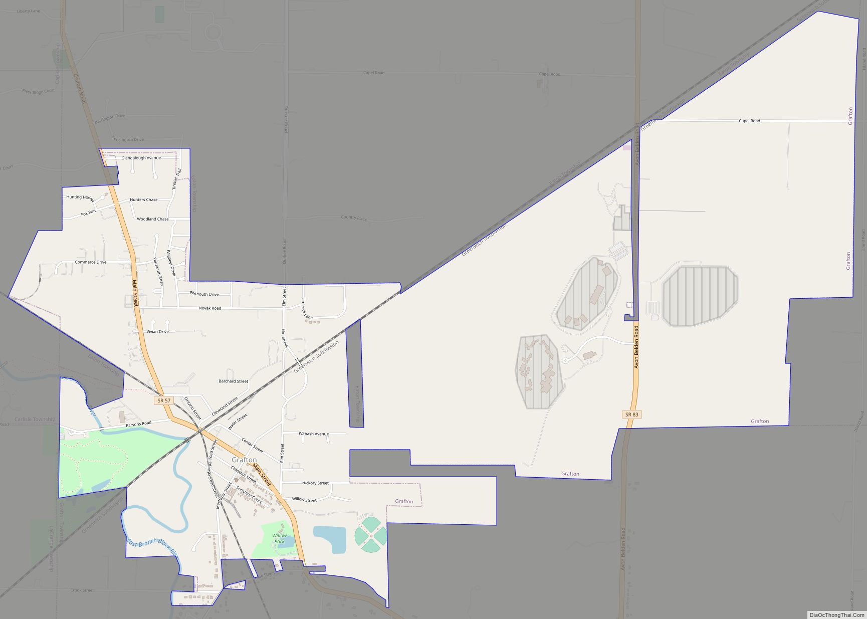
Grafton is a village in Lorain County, Ohio, United States, along the East Branch of the Black River. The population was 6,636 at the 2010 census. The Lorain Correctional Institution and several other prisons are located in and near Grafton. Grafton village overview: Name: Grafton village LSAD Code: 47 LSAD Description: village (suffix) State: Ohio … Read more

Map of Greenhills village

Map of Greenhills village

Greenhills is a village in Hamilton County, Ohio, United States. The population was 3,741 at the 2020 census. A planned community, it was established by the United States government during the Great Depression. Most of the village is a National Historic Landmark for its history as a planned modernist community. Greenhills village overview: Name: Greenhills … Read more

Map of Greenfield village, Ohio

Map of Greenfield village, Ohio

Greenfield is a large village in Highland and Ross counties, Ohio, United States. As of the 2020 census, the population was 4,339. Greenfield is most well known because of its rich history, including its community members helping in the underground railroad, new industries, and McClain High School. Greenfield village overview: Name: Greenfield village LSAD Code: … Read more

Map of Green city, Ohio

Map of Green city, Ohio

Green is a city in southeastern Summit County, Ohio, United States. The population was 27,475 at the 2020 census. It is a suburban community between Akron and Canton and is part of the Akron metropolitan area. Green city overview: Name: Green city LSAD Code: 25 LSAD Description: city (suffix) State: Ohio County: Summit County Elevation: … Read more

Map of Green Springs village

Map of Green Springs village

Green Springs is a village in Sandusky and Seneca counties in the U.S. state of Ohio. The population was 1,368 at the 2010 census. Its “claim to fame” is Mineral Springs, the largest natural sulfur spring in the world. Elmwood at the Springs Healthcare Center, formerly St. Francis Health Care Centre, is located there. Green … Read more

Map of Green Meadows CDP

Map of Green Meadows CDP

Green Meadows is a census-designated place (CDP) in Mad River Township, Clark County, Ohio, United States, on the west side of Enon. The population was 2,327 at the 2010 census. It is part of the Springfield, Ohio Metropolitan Statistical Area. Green Meadows CDP overview: Name: Green Meadows CDP LSAD Code: 57 LSAD Description: CDP (suffix) … Read more