Map of Ironton city, Ohio

Map of Ironton city, Ohio

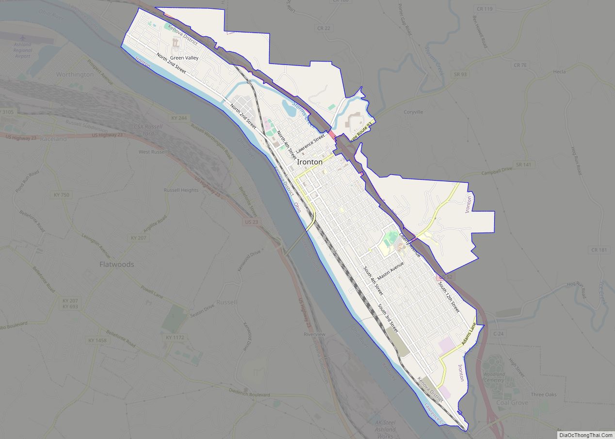
Ironton is a city in and the county seat of Lawrence County, Ohio, United States. Located in southernmost Ohio along the Ohio River, it is 20 miles (32 km) northwest of Huntington, West Virginia. The population was 10,571 at the 2020 census. Ironton is part of the Huntington–Ashland metropolitan area. The city’s name is a contraction … Read more

Map of Jeromesville village

Map of Jeromesville village

Jeromesville is a village in Ashland County, Ohio, United States. The population was 531 at the 2020 census. Jeromesville village overview: Name: Jeromesville village LSAD Code: 47 LSAD Description: village (suffix) State: Ohio County: Ashland County Incorporated: February 14, 1815 Elevation: 1,007 ft (307 m) Total Area: 0.35 sq mi (0.90 km²) Land Area: 0.34 sq mi (0.89 km²) Water Area: 0.00 sq mi (0.00 km²) … Read more

Map of Kelleys Island village

Map of Kelleys Island village

Kelleys Island is both a village in Erie County, Ohio, and the island which it fully occupies in Lake Erie. The British originally called it Sandusky Island. Later the United States took it over and officially designated it as Island Number 6 and Cunningham Island. It was renamed as Kelleys Island in 1840 by brothers … Read more

Map of Kansas CDP, Ohio

Map of Kansas CDP, Ohio

Kansas is a census-designated place in northwestern Liberty Township, Seneca County, Ohio, United States. It has a post office with the ZIP code 44841. It is located along State Route 635. Kansas was platted in early 1855 along a line of the Lake Erie and Louisville Railroad. The community took its name from the Kansas … Read more

Map of Kanauga CDP

Map of Kanauga CDP

Kanauga is an unincorporated community and census-designated place (CDP) in Gallia County, Ohio, United States. As of the 2010 census it had a population of 175. Kanauga CDP overview: Name: Kanauga CDP LSAD Code: 57 LSAD Description: CDP (suffix) State: Ohio County: Gallia County Elevation: 570 ft (170 m) Total Area: 0.32 sq mi (0.83 km²) Land Area: 0.29 sq mi (0.75 km²) … Read more

Map of Kalida village

Map of Kalida village

Kalida is a village in Putnam County, Ohio, United States. The population was 1,542 at the 2010 census. Kalida village overview: Name: Kalida village LSAD Code: 47 LSAD Description: village (suffix) State: Ohio County: Putnam County Elevation: 725 ft (221 m) Total Area: 1.70 sq mi (4.39 km²) Land Area: 1.68 sq mi (4.35 km²) Water Area: 0.01 sq mi (0.04 km²) Total Population: 1,455 Population … Read more

Map of Junction City village, Ohio

Map of Junction City village, Ohio

Junction City is a village in Perry County, Ohio, United States. The population was 721 at the 2020 census. Junction City village overview: Name: Junction City village LSAD Code: 47 LSAD Description: village (suffix) State: Ohio County: Perry County Elevation: 833 ft (254 m) Total Area: 0.65 sq mi (1.68 km²) Land Area: 0.64 sq mi (1.67 km²) Water Area: 0.01 sq mi (0.01 km²) Total … Read more

Map of Johnstown village, Ohio

Map of Johnstown village, Ohio

Johnstown is a city in Licking County, Ohio, United States. The population was 5,182 at the 2020 census. The city is currently served by a seven-person City Council which includes the current Mayor Donald D. Barnard, Jr. Johnstown was the home of William A. Ashbrook, an American businessman, newspaper publisher, and Democratic politician from Ohio. … Read more

Map of Jewett village, Ohio

Map of Jewett village, Ohio

Jewett is a village in Harrison County, Ohio, United States. The population was 692 at the 2010 census. Jewett village overview: Name: Jewett village LSAD Code: 47 LSAD Description: village (suffix) State: Ohio County: Harrison County Elevation: 994 ft (303 m) Total Area: 0.51 sq mi (1.32 km²) Land Area: 0.51 sq mi (1.32 km²) Water Area: 0.00 sq mi (0.00 km²) Total Population: 554 Population … Read more

Map of Jerusalem village

Map of Jerusalem village

Jerusalem is a village in Monroe County, Ohio, United States. The population was 121 at the 2020 census. Jerusalem village overview: Name: Jerusalem village LSAD Code: 47 LSAD Description: village (suffix) State: Ohio County: Monroe County Elevation: 1,263 ft (385 m) Total Area: 0.24 sq mi (0.63 km²) Land Area: 0.24 sq mi (0.63 km²) Water Area: 0.00 sq mi (0.00 km²) Total Population: 121 Population … Read more

Map of Jerry City village

Map of Jerry City village

Jerry City is a village in Wood County, Ohio, United States. The population was 427 at the 2010 census. Jerry City village overview: Name: Jerry City village LSAD Code: 47 LSAD Description: village (suffix) State: Ohio County: Wood County Elevation: 696 ft (212 m) Total Area: 1.01 sq mi (2.61 km²) Land Area: 1.01 sq mi (2.61 km²) Water Area: 0.00 sq mi (0.00 km²) Total … Read more

Map of Kilbourne CDP, Ohio

Map of Kilbourne CDP, Ohio

Kilbourne is a census-designated place in eastern Brown Township, Delaware County, Ohio, United States. As of the 2010 census it had a population of 139. The community has a post office with the ZIP code of 43032. It lies along State Route 521. Kilbourne CDP overview: Name: Kilbourne CDP LSAD Code: 57 LSAD Description: CDP … Read more