Map of Kings Mills CDP
Kings Mills is a census-designated place in the southwestern corner of Deerfield Township, Warren County, Ohio, United States, on the western shore of the Little Miami River. Located along I-71 twenty miles northeast of Cincinnati, it is less than a mile east of Mason, two miles southwest of South Lebanon, two and one-half miles north ... Read more
Map of Kings Mills CDP
Map of Kimbolton CDP
Kimbolton is an unincorporated community and census-designated place in Guernsey County, Ohio, United States, along Wills Creek. The population was 144 at the 2010 census, down from 190 at the 2000 census, at which time it was a village. Kimbolton CDP overview: Name: Kimbolton CDP LSAD Code: 57 LSAD Description: CDP (suffix) State: Ohio County: ... Read more
Map of Kimbolton CDP
Map of Killbuck village
Killbuck is a village in Holmes County, Ohio, United States, along Killbuck Creek. The population was 817 at the 2010 census. Local tradition states the name is derived from an incident when a deer was killed near the town site. According to a later source, the village was named for Killbuck, a Delaware Indian chief. ... Read more
Map of Killbuck village
Map of Kilbourne CDP, Ohio
Kilbourne is a census-designated place in eastern Brown Township, Delaware County, Ohio, United States. As of the 2010 census it had a population of 139. The community has a post office with the ZIP code of 43032. It lies along State Route 521. Kilbourne CDP overview: Name: Kilbourne CDP LSAD Code: 57 LSAD Description: CDP ... Read more
Map of Kilbourne CDP, Ohio
Map of Kidron CDP
Kidron is a census-designated place in southwestern Sugar Creek Township, Wayne County, Ohio, United States. Kidron CDP overview: Name: Kidron CDP LSAD Code: 57 LSAD Description: CDP (suffix) State: Ohio County: Wayne County FIPS code: 3940096 Online Interactive Map Kidron online map. Source: Basemap layers from Google Map, Open Street Map (OSM), Arcgisonline, Wmflabs. Boundary ... Read more
Map of Kidron CDP
Map of Kettlersville village
Kettlersville is a village in Shelby County, Ohio, United States. The population was 179 at the 2010 United States census. The “s” is traditionally silent when pronouncing Kettlersville as “Kettler-ville” by the locals. Kettlersville village overview: Name: Kettlersville village LSAD Code: 47 LSAD Description: village (suffix) State: Ohio County: Shelby County Elevation: 974 ft (297 m) Total ... Read more
Map of Kettlersville village
Map of Kettering city, Ohio
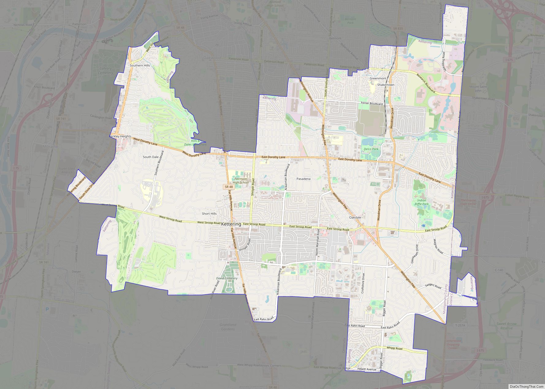
Kettering is a city in Montgomery County, Ohio, United States. It is an inner suburb of Dayton, Ohio. As of the 2020 census, the city had a population of 57,862, making it the largest suburb in the Dayton metropolitan area. Kettering city overview: Name: Kettering city LSAD Code: 25 LSAD Description: city (suffix) State: Ohio ... Read more
Map of Kettering city, Ohio
Map of Kenwood CDP, Ohio
Kenwood is a census-designated place (CDP) in Sycamore Township, Hamilton County, Ohio, United States. The population was 7,570 at the 2020 census. It is a major shopping destination for the Cincinnati area, featuring properties such as Kenwood Towne Centre and The Kenwood Collection. Kenwood CDP overview: Name: Kenwood CDP LSAD Code: 57 LSAD Description: CDP ... Read more
Map of Kenwood CDP, Ohio
Map of Kenton city, Ohio
Kenton is a city in and the county seat of Hardin County, Ohio, United States, located in the west-central part of Ohio about 57 mi (92 km) northwest of Columbus and 70 mi (113 km) south of Toledo. Its population was 7,947 at the 2020 census. The city was named for frontiersman Simon Kenton of Kentucky and Ohio. Kenton ... Read more
Map of Kenton city, Ohio
Map of Kirtland city, Ohio
Kirtland is a city in Lake County, Ohio, United States. The population was 6,937 at the 2020 census. Kirtland is known for being the early headquarters of the Latter Day Saint movement from 1831 to 1837 and is the site of the movement’s first temple, the Kirtland Temple, completed in 1836. The city is also ... Read more
Map of Kirtland city, Ohio
Map of Kirtland Hills village
Kirtland Hills is a village in Lake County, Ohio, United States and a rural suburb of Cleveland. The population was 692 at the 2020 census. Kirtland Hills village overview: Name: Kirtland Hills village LSAD Code: 47 LSAD Description: village (suffix) State: Ohio County: Lake County Elevation: 801 ft (244 m) Total Area: 5.65 sq mi (14.63 km²) Land Area: 5.57 sq mi ... Read more
Map of Kirtland Hills village
Map of Kirkersville village
Kirkersville is a village in Licking County, Ohio, United States, along the South Fork of the Licking River. The population was 525 at the 2010 census. Kirkersville was platted in 1832 by Dr. William C. Kirker, and named for him. Kirkersville village overview: Name: Kirkersville village LSAD Code: 47 LSAD Description: village (suffix) State: Ohio ... Read more
Map of Kirkersville village