Map of Lake Milton CDP

Map of Lake Milton CDP

Lake Milton is a census-designated place in central Milton Township, Mahoning County, Ohio, United States. The population was 637 at the 2020 census. Located in northwestern Mahoning County, it sits along the shore of the Lake Milton reservoir, along with the village of Craig Beach. It is part of the Youngstown–Warren metropolitan area. Lake Milton … Read more

Map of Lake Lorelei CDP

Map of Lake Lorelei CDP

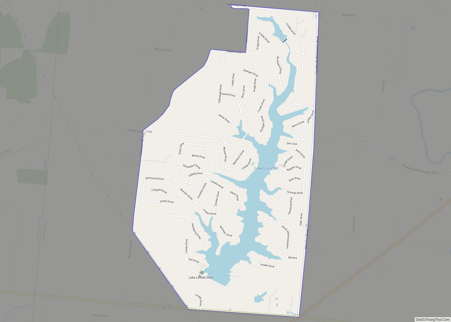
Lake Lorelei is a gated community and census-designated place in Brown County, Ohio, United States, near the village of Fayetteville. As of the 2010 census, it had a population of 1,170. Lake Lorelei CDP overview: Name: Lake Lorelei CDP LSAD Code: 57 LSAD Description: CDP (suffix) State: Ohio County: Brown County Elevation: 925 ft (282 m) Total … Read more

Map of Lake Lakengren CDP

Map of Lake Lakengren CDP

Lake Lakengren (lock-n-grin, a Viking name meaning “Lake of the emerald green hills”) is an unincorporated community and census-designated place in Gasper Township, Preble County, Ohio, United States. The population was 3,387 at the 2020 census. A private planned community located 3 miles (4.8 km) southwest of Eaton, the northern portion of Lake Lakengren is served … Read more

Map of Lake Darby CDP

Map of Lake Darby CDP

Lake Darby is an unincorporated community and census-designated place in Franklin County, Ohio, United States, located mostly in Prairie Township and partly in Brown Township. It is more commonly known among locals as Darby Estates, which is also the name of the older housing development there, with the newer development called “West Point”. As of … Read more

Map of Lake Buckhorn CDP

Map of Lake Buckhorn CDP

Lake Buckhorn is a census-designated place (CDP) in Mechanic Township, Holmes County, Ohio, United States. As of the 2020 census it had a population of 720. It is a private, members-only gated community. The community is built around 220-acre (89 ha) Lake Buckhorn, a reservoir impounded in 1967. Lake Buckhorn CDP overview: Name: Lake Buckhorn CDP … Read more

Map of Landen CDP

Map of Landen CDP

Landen is a census-designated place (CDP) in Deerfield Township, Warren County, Ohio, United States. The population was 6,995 at the 2020 census. It is located around Columbia Road and Montgomery Road in the southeastern part of the township. It surrounds Twenty Mile Stand and near Fosters. Landen was named after Theodophilus James Landen, an early … Read more

Map of Lancaster city, Ohio

Map of Lancaster city, Ohio

Lancaster (locally /ˈlæŋk(ə)stər/ LANK-(ə-)stər) is a city in Fairfield County, Ohio, in the south-central part of the state. As of the 2020 census, the city population was 40,552. The city is near the Hocking River, about 33 miles (53 km) southeast of Columbus and 38 miles (61 km) southwest of Zanesville. It is the county seat of … Read more

Map of Lakewood city, Ohio

Map of Lakewood city, Ohio

Lakewood is a city in Cuyahoga County, Ohio, United States, on the southern shore of Lake Erie. Established in 1889, it is one of Cleveland’s historical streetcar suburbs and part of the Cleveland metropolitan area. The population was 50,942 at the 2020 census, making it the third largest city in Cuyahoga County, behind Cleveland and … Read more

Map of Lakeview village, Ohio

Map of Lakeview village, Ohio

Lakeview is a village in Logan County, Ohio, United States. The population was 1,072 at the 2010 census. A branch of the Logan County District Library serves the Lakeview community. Lakeview village overview: Name: Lakeview village LSAD Code: 47 LSAD Description: village (suffix) State: Ohio County: Logan County Elevation: 994 ft (303 m) Total Area: 0.71 sq mi (1.85 km²) … Read more

Map of Lakeside CDP, Ohio

Map of Lakeside CDP, Ohio

Lakeside is a private community and census-designated place in Danbury Township, Ottawa County, Ohio, United States, on the shores of Lake Erie. It was formed in 1873 by members of the Methodist Church and remains a church-affiliated vacation resort and United Methodist Annual Conference site. It is one of only a few continuously operating Independent … Read more

Map of Lakemore village

Map of Lakemore village

Lakemore is a village in Summit County, Ohio, United States. The population was 2,926 at the 2020 census. It is part of the Akron metropolitan area. Lakemore village overview: Name: Lakemore village LSAD Code: 47 LSAD Description: village (suffix) State: Ohio County: Summit County Elevation: 1,086 ft (331 m) Total Area: 1.66 sq mi (4.30 km²) Land Area: 1.45 sq mi (3.76 km²) … Read more

Map of Lakeline village

Map of Lakeline village

Lakeline is a village in Lake County, Ohio, United States. The population was 226 at the 2010 census. Lakeline village overview: Name: Lakeline village LSAD Code: 47 LSAD Description: village (suffix) State: Ohio County: Lake County Elevation: 620 ft (189 m) Total Area: 0.09 sq mi (0.23 km²) Land Area: 0.09 sq mi (0.23 km²) Water Area: 0.00 sq mi (0.00 km²) Total Population: 216 Population … Read more