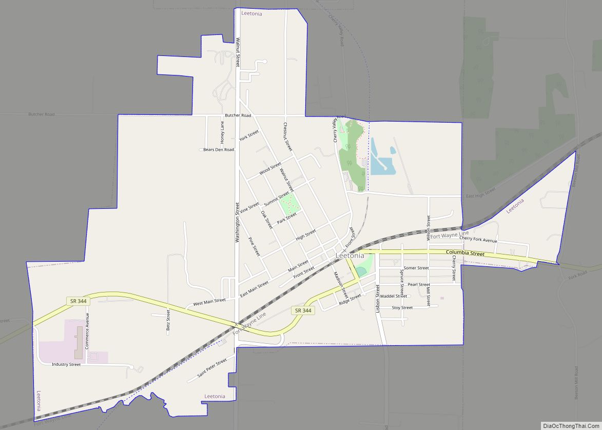
Map of Latty village

Map of Latty village

Latty is a village in Paulding County, Ohio, United States. The population was 193 at the 2010 census. Latty village overview: Name: Latty village LSAD Code: 47 LSAD Description: village (suffix) State: Ohio County: Paulding County Elevation: 728 ft (222 m) Total Area: 0.27 sq mi (0.70 km²) Land Area: 0.27 sq mi (0.70 km²) Water Area: 0.00 sq mi (0.00 km²) Total Population: 165 Population … Read more

Map of Lima city, Ohio

Map of Lima city, Ohio

Lima (/ˈlaɪmə/ LY-mə) is a city in and the county seat of Allen County, Ohio, United States. The municipality is located in northwest Ohio along Interstate 75 approximately 72 miles (116 km) north of Dayton, 78 miles (126 km) southwest of Toledo, and 63 mi (101 km) southeast of Fort Wayne, Indiana. As of the 2020 census, the city … Read more

Map of Liberty Center village

Map of Liberty Center village

Liberty Center is a village in Henry County, Ohio, United States. The population was 1,180 at the 2010 census. Liberty Center village overview: Name: Liberty Center village LSAD Code: 47 LSAD Description: village (suffix) State: Ohio County: Henry County Elevation: 679 ft (207 m) Total Area: 1.03 sq mi (2.68 km²) Land Area: 1.03 sq mi (2.68 km²) Water Area: 0.00 sq mi (0.00 km²) Total … Read more

Map of Lexington village, Ohio

Map of Lexington village, Ohio

Lexington is a village along the Clear Fork River in Troy Township and Washington Township in Richland County in the U.S. state of Ohio. It is part of the Mansfield, Ohio Metropolitan Statistical Area. The population was 4,822 at the 2010 census, an increase from 4,165 in 2000. The Mid-Ohio Sports Car Course is located … Read more

Map of Lewisville village, Ohio

Map of Lewisville village, Ohio

Lewisville is a village in Monroe County, Ohio, United States. The population was 184 at the 2020 census. Lewisville village overview: Name: Lewisville village LSAD Code: 47 LSAD Description: village (suffix) State: Ohio County: Monroe County Elevation: 1,201 ft (366 m) Total Area: 0.37 sq mi (0.96 km²) Land Area: 0.37 sq mi (0.96 km²) Water Area: 0.00 sq mi (0.00 km²) Total Population: 184 Population … Read more

Map of Lewistown CDP, Ohio

Map of Lewistown CDP, Ohio

Lewistown (also Lewis Town or Lewiston) is an unincorporated community and census-designated place (CDP) in central Washington Township, Logan County, Ohio, United States. As of the 2010 census, the population was 222. Until the 1829 Treaty of Lewistown, the community was the site of a Shawnee Native American reservation, also called Lewistown, named after Captain … Read more

Map of Linndale village

Map of Linndale village

Linndale is the smallest village in Cuyahoga County, Ohio, United States. It is landlocked, surrounded by the city of Cleveland and the suburb of Brooklyn. According to the 2020 census, the population was 108. Linndale village overview: Name: Linndale village LSAD Code: 47 LSAD Description: village (suffix) State: Ohio County: Cuyahoga County Elevation: 755 ft (230 m) … Read more

Map of Lindsey village

Map of Lindsey village

Lindsey is a village in Sandusky County, Ohio, United States, near the halfway point of the route between Detroit and Cleveland. The population was 446 at the 2010 census. The National Arbor Day Foundation has designated Lindsey as a Tree City USA. Lindsey village overview: Name: Lindsey village LSAD Code: 47 LSAD Description: village (suffix) … Read more

Map of Lincoln Village CDP, Ohio

Map of Lincoln Village CDP, Ohio

Lincoln Village is a census-designated place (CDP) in Prairie Township, Franklin County, Ohio, United States. It is centered near the intersection of US 40 and I-270 on the west side of Columbus. As of the 2010 census, the population was 9,032, down from 9,482 at the 2000 census. Lincoln Village was started in 1955 as … Read more

Map of Lincoln Heights village

Map of Lincoln Heights village

Lincoln Heights is a village in Hamilton County, Ohio, United States. The population was 3,144 at the 2020 census. It is a suburb of Cincinnati. Lincoln Heights village overview: Name: Lincoln Heights village LSAD Code: 47 LSAD Description: village (suffix) State: Ohio County: Hamilton County Elevation: 594 ft (181 m) Total Area: 0.74 sq mi (1.92 km²) Land Area: 0.74 sq mi … Read more

Map of Limaville village

Map of Limaville village

Limaville is a census-designated place (CDP) and former village in Stark County, Ohio, United States. The population was 151 at the 2010 census. It is part of the Canton–Massillon Metropolitan Statistical Area. Limaville village overview: Name: Limaville village LSAD Code: 47 LSAD Description: village (suffix) State: Ohio County: Stark County Elevation: 1,060 ft (323 m) Total Area: … Read more

Map of London city, Ohio

Map of London city, Ohio

London is a city in and the county seat of Madison County, Ohio, United States. Located about 25 miles (40 km) southwest of the Ohio capital of Columbus, London was established in 1811 to serve as the county seat. The population was 10,279 at the 2020 census. The ZIP code is 43140. London city overview: Name: … Read more