Map of Middle Point village
Middle Point is a village in Van Wert County, Ohio, United States. The population was 576 at the 2010 census. It is included within the Van Wert, Ohio Micropolitan Statistical Area. Middle Point village overview: Name: Middle Point village LSAD Code: 47 LSAD Description: village (suffix) State: Ohio County: Van Wert County Elevation: 781 ft (238 m) ... Read more
Map of Middle Point village
Map of Miamiville CDP
Miamiville is an unincorporated community and census-designated place (CDP) in western Miami Township, Clermont County, Ohio, United States, along the Little Miami River and the Loveland Bike Trail. It had a population of 205 at the 2020 census. It has a post office with the ZIP code 45147. Miamiville CDP overview: Name: Miamiville CDP LSAD ... Read more
Map of Miamiville CDP
Map of Miamitown CDP
Miamitown is a census-designated place (CDP) in western Whitewater Township, Hamilton County, Ohio, United States. The population was 1,256 at the 2020 census. It has a post office with the ZIP code 45041. Miamitown CDP overview: Name: Miamitown CDP LSAD Code: 57 LSAD Description: CDP (suffix) State: Ohio County: Hamilton County Elevation: 525 ft (160 m) Total ... Read more
Map of Miamitown CDP
Map of Miamisburg city
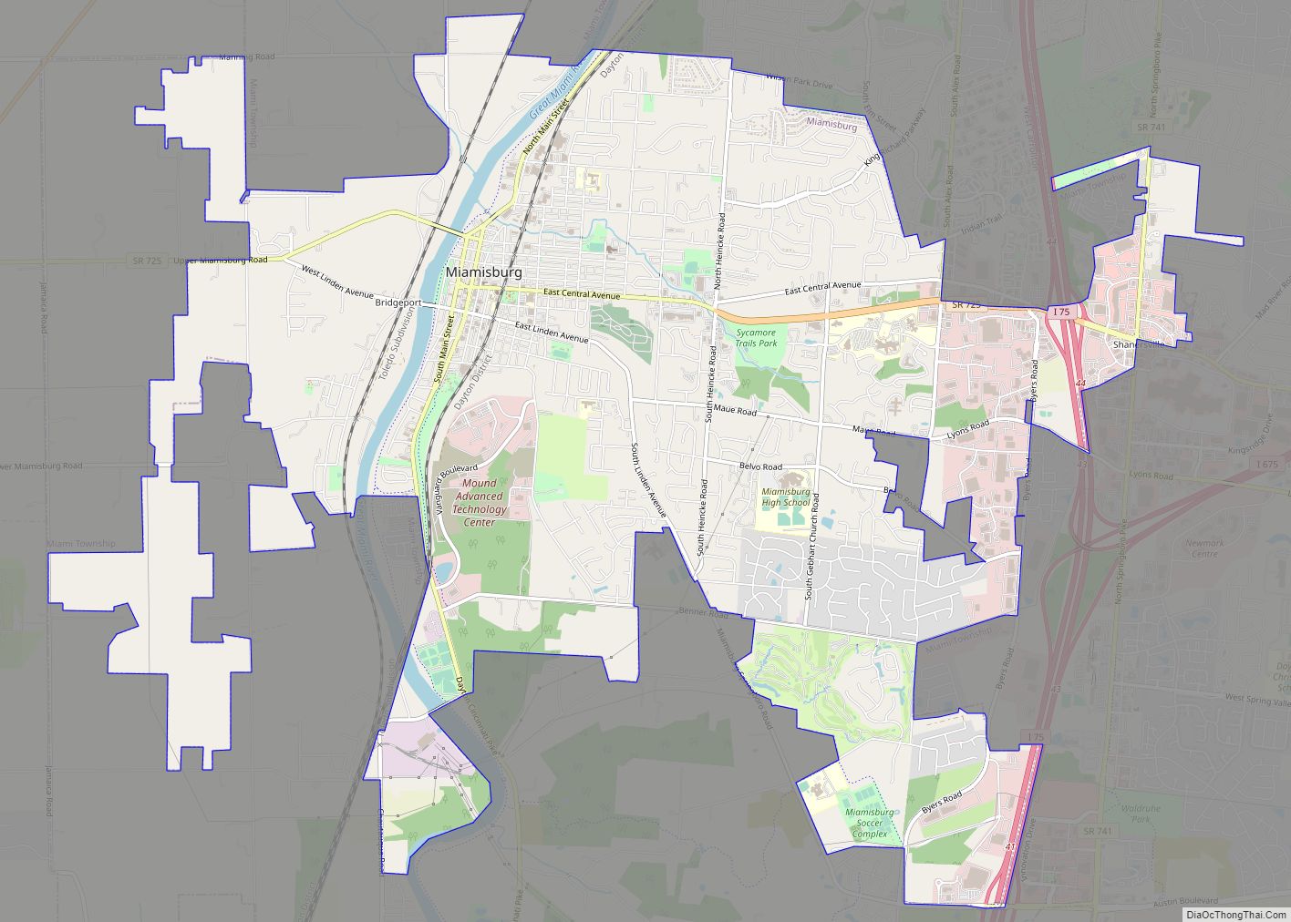
Miamisburg (/maɪˈæmizbɜːrɡ/ my-AM-eez-burg) is a city in southern Montgomery County, Ohio, United States. The population was 19,923 at the 2020 census. A suburb of Dayton, it is part of the Dayton metropolitan area. Named after the Miami people, Miamisburg is known for its industrial history, particularly its nuclear operations during World War II, and retail ... Read more
Map of Miamisburg city
Map of Miami Heights CDP
Miami Heights is a census-designated place (CDP) in Miami Township, Hamilton County, Ohio, United States. The population was 4,731 at the 2010 census. Miami Heights CDP overview: Name: Miami Heights CDP LSAD Code: 57 LSAD Description: CDP (suffix) State: Ohio County: Hamilton County Elevation: 830 ft (250 m) Total Area: 3.84 sq mi (9.94 km²) Land Area: 3.84 sq mi (9.94 km²) Water ... Read more
Map of Miami Heights CDP
Map of Milford city, Ohio
Milford is a city in Clermont and Hamilton counties in the U.S. state of Ohio. Located along the Little Miami River and its East Fork in the southwestern part of the state, it is a part of the Cincinnati metropolitan area. The population was 6,582 at the 2020 census. Milford city overview: Name: Milford city ... Read more
Map of Milford city, Ohio
Map of Milford Center village
Milford Center is a village in Union County, Ohio, United States. The population was 792 at the 2010 census. Milford Center village overview: Name: Milford Center village LSAD Code: 47 LSAD Description: village (suffix) State: Ohio County: Union County Elevation: 994 ft (303 m) Total Area: 0.43 sq mi (1.12 km²) Land Area: 0.42 sq mi (1.09 km²) Water Area: 0.01 sq mi (0.03 km²) Total ... Read more
Map of Milford Center village
Map of Milan village, Ohio
Milan (/ˈmaɪlən/ MY-lən) is a village in Erie and Huron counties in the U.S. state of Ohio. The population was 1,367 at the 2010 census. It is best known as the birthplace and childhood home of Thomas Edison. The Erie County portion of Milan is part of the Sandusky Metropolitan Statistical Area, while the Huron ... Read more
Map of Milan village, Ohio
Map of Mifflin village, Ohio
Mifflin is a village in Mifflin Township, Ashland County, Ohio, United States. The population was 158 at the 2020 census. Mifflin village overview: Name: Mifflin village LSAD Code: 47 LSAD Description: village (suffix) State: Ohio County: Ashland County Elevation: 1,070 ft (326 m) Total Area: 0.18 sq mi (0.47 km²) Land Area: 0.18 sq mi (0.47 km²) Water Area: 0.00 sq mi (0.00 km²) Total Population: ... Read more
Map of Mifflin village, Ohio
Map of Midway village, Ohio
Midway (also called Sedalia) is a village in Range Township, Madison County, Ohio, United States. The population was 322 at the 2010 census. Midway is also called “Sedalia” by some sources. Addresses with its ZIP code, 43151, are officially located in Sedalia. Midway village overview: Name: Midway village LSAD Code: 47 LSAD Description: village (suffix) ... Read more
Map of Midway village, Ohio
Map of Midvale village, Ohio
Midvale is a village in Tuscarawas County, Ohio, United States. The population was 754 at the 2010 census. Midvale village overview: Name: Midvale village LSAD Code: 47 LSAD Description: village (suffix) State: Ohio County: Tuscarawas County Elevation: 860 ft (262 m) Total Area: 0.74 sq mi (1.91 km²) Land Area: 0.74 sq mi (1.91 km²) Water Area: 0.00 sq mi (0.00 km²) Total Population: 673 Population ... Read more
Map of Midvale village, Ohio
Map of Midland village, Ohio
Midland is a village in Clinton County, Ohio, United States. The population was 315 at the 2010 census. Midland village overview: Name: Midland village LSAD Code: 47 LSAD Description: village (suffix) State: Ohio County: Clinton County Elevation: 984 ft (300 m) Total Area: 0.36 sq mi (0.92 km²) Land Area: 0.36 sq mi (0.92 km²) Water Area: 0.00 sq mi (0.00 km²) Total Population: 307 Population ... Read more
Map of Midland village, Ohio