Map of Morrow village, Ohio
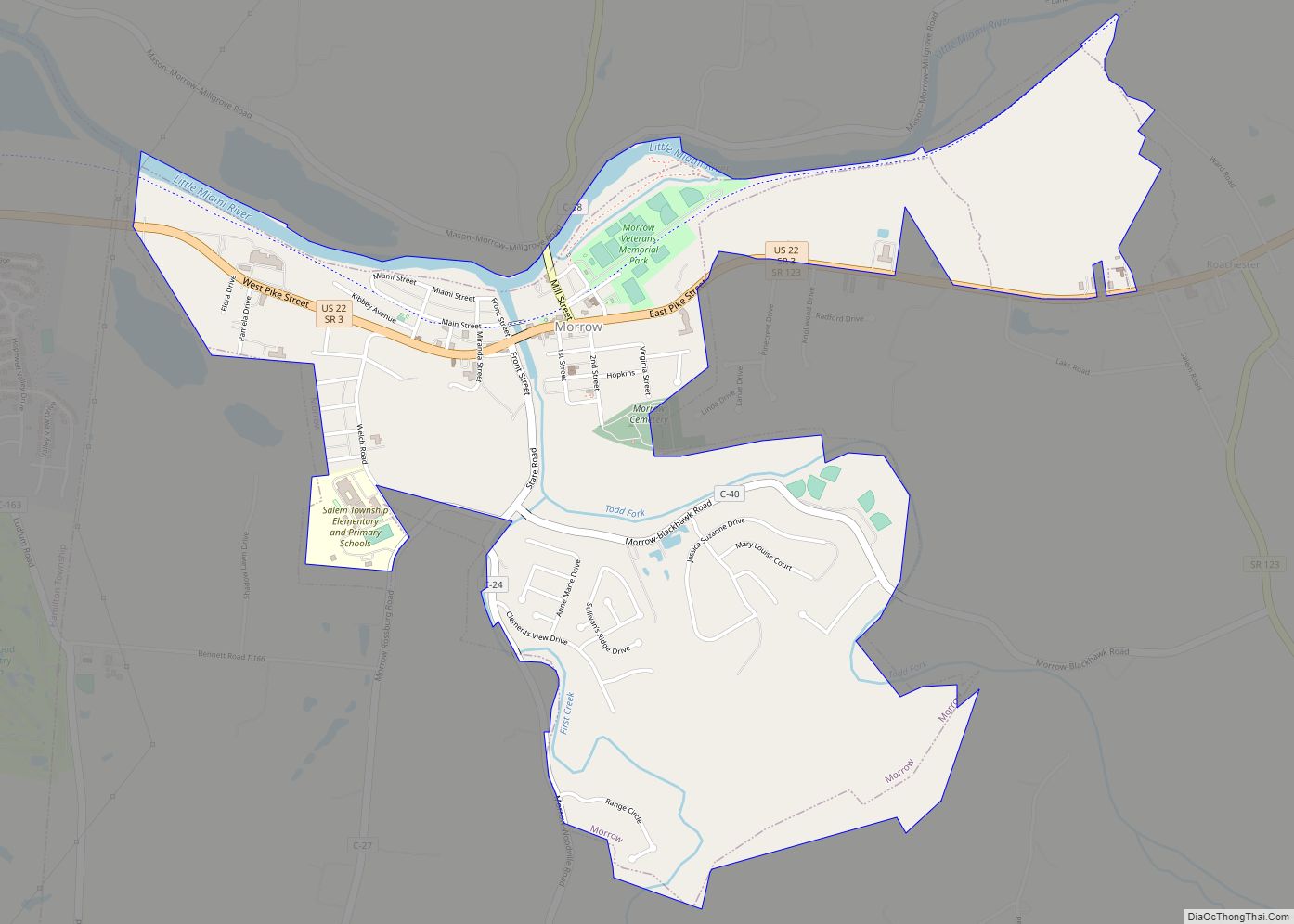
Morrow is a village in Salem Township, Warren County, Ohio, United States. The population was 2,049 at the 2020 census. Morrow village overview: Name: Morrow village LSAD Code: 47 LSAD Description: village (suffix) State: Ohio County: Warren County Elevation: 640 ft (195 m) Total Area: 2.11 sq mi (5.45 km²) Land Area: 2.04 sq mi (5.28 km²) Water Area: 0.07 sq mi (0.18 km²) Total Population: ... Read more
Map of Morrow village, Ohio
Map of Morristown village, Ohio
Morristown is a village in Belmont County, Ohio, United States. The population was 248 at the 2020 census. It is part of the Wheeling metropolitan area. Morristown village overview: Name: Morristown village LSAD Code: 47 LSAD Description: village (suffix) State: Ohio County: Belmont County Elevation: 1,266 ft (386 m) Total Area: 0.63 sq mi (1.63 km²) Land Area: 0.63 sq mi (1.63 km²) ... Read more
Map of Morristown village, Ohio
Map of Morral village
Morral is a village in Marion County, Ohio, United States. The population was 399 at the 2010 census. Morral is served by Ridgedale Local School District. Morral village overview: Name: Morral village LSAD Code: 47 LSAD Description: village (suffix) State: Ohio County: Marion County Elevation: 909 ft (277 m) Total Area: 2.70 sq mi (7.00 km²) Land Area: 2.70 sq mi (7.00 km²) ... Read more
Map of Morral village
Map of Morgandale CDP
Morgandale is an unincorporated community and census-designated place in Trumbull County, Ohio, United States. The population was 1,139 at the 2020 census. It is part of the Youngstown–Warren metropolitan area. Morgandale CDP overview: Name: Morgandale CDP LSAD Code: 57 LSAD Description: CDP (suffix) State: Ohio County: Trumbull County Elevation: 925 ft (282 m) Total Area: 2.65 sq mi (6.87 km²) ... Read more
Map of Morgandale CDP
Map of Moreland Hills village
Moreland Hills is a village in eastern Cuyahoga County, Ohio, United States. The population was 3,466 at the 2020 census. An eastern suburb of Cleveland, it is part of the Cleveland metropolitan area. Moreland Hills village overview: Name: Moreland Hills village LSAD Code: 47 LSAD Description: village (suffix) State: Ohio County: Cuyahoga County Elevation: 1,040 ft ... Read more
Map of Moreland Hills village
Map of Moraine city
Moraine is a city in Montgomery County, Ohio, United States. Situated on the banks of the Great Miami River, Moraine is an inner suburb of Dayton, Ohio and a part of the Dayton metropolitan area. The population was 6,393 at the 2020 census. Moraine city overview: Name: Moraine city LSAD Code: 25 LSAD Description: city ... Read more
Map of Moraine city
Map of Montrose-Ghent CDP
Montrose-Ghent is a census-designated place (CDP) in Summit County, Ohio, United States, composed of the unincorporated communities of Montrose and Ghent. The population was 5,261 at the 2000 census. It is part of the Akron Metropolitan Statistical Area. Despite sharing a commercial district with Fairlawn, the regions are administratively separate. Montrose-Ghent CDP overview: Name: Montrose-Ghent ... Read more
Map of Montrose-Ghent CDP
Map of Montpelier village, Ohio
Montpelier is a village in Williams County, Ohio, United States. The population was 4,072 at the 2010 census. Montpelier village overview: Name: Montpelier village LSAD Code: 47 LSAD Description: village (suffix) State: Ohio County: Williams County Elevation: 856 ft (261 m) Total Area: 2.88 sq mi (7.47 km²) Land Area: 2.87 sq mi (7.44 km²) Water Area: 0.01 sq mi (0.03 km²) Total Population: 3,942 Population ... Read more
Map of Montpelier village, Ohio
Map of Montgomery city, Ohio
Montgomery is a city in Hamilton County, Ohio, United States, settled in 1795. The town was a coach stop on the Cincinnati-Zanesville Road, later known as the Montgomery Pike, with an inn, two taverns, a grist mill and a carding mill to process its agricultural products. It would remain a rather sleepy hamlet until the ... Read more
Map of Montgomery city, Ohio
Map of Mount Healthy Heights CDP
Mount Healthy Heights is a census-designated place (CDP) in Hamilton County, Ohio, United States. The population was 2,918 at the 2020 census. Mount Healthy Heights CDP overview: Name: Mount Healthy Heights CDP LSAD Code: 57 LSAD Description: CDP (suffix) State: Ohio County: Hamilton County Elevation: 846 ft (258 m) Total Area: 0.74 sq mi (1.92 km²) Land Area: 0.73 sq mi (1.90 km²) ... Read more
Map of Mount Healthy Heights CDP
Map of Mount Gilead village, Ohio
Mount Gilead is a village and the county seat of Morrow County, Ohio, United States. It is located 41 miles (66 km) northeast of Columbus. The population was 3,660 at the 2010 census. It is the center of population of Ohio. The village was established in 1832, eight years after white settlers arrived in the ... Read more
Map of Mount Gilead village, Ohio
Map of Mount Eaton village
Mount Eaton is a village in Wayne County, Ohio, United States. The population was 241 at the 2010 census. Mount Eaton village overview: Name: Mount Eaton village LSAD Code: 47 LSAD Description: village (suffix) State: Ohio County: Wayne County Elevation: 1,250 ft (381 m) Total Area: 0.17 sq mi (0.44 km²) Land Area: 0.17 sq mi (0.44 km²) Water Area: 0.00 sq mi (0.00 km²) Total ... Read more
Map of Mount Eaton village