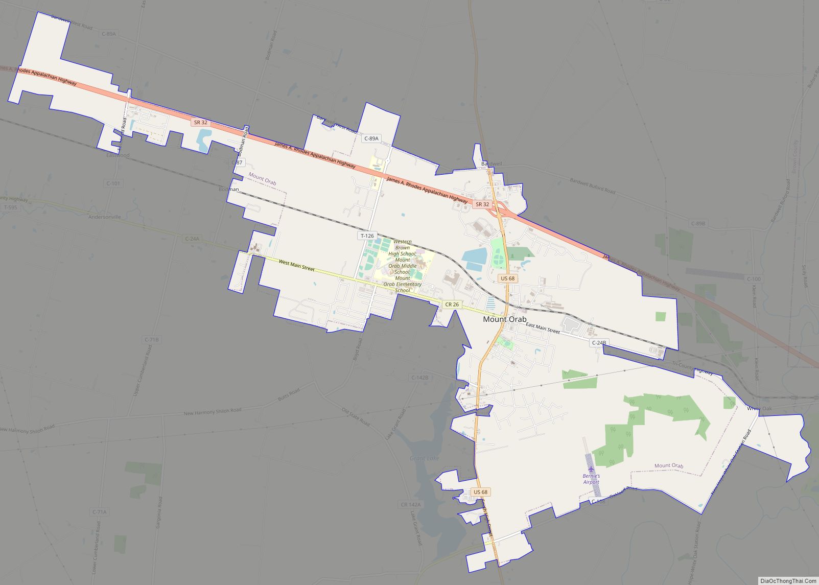
Mount Orab is a village in Brown County, Ohio, United States. The population was 4,347 as of the 2020 census. Mount Orab village overview: Name: Mount Orab village LSAD Code: 47 LSAD Description: village (suffix) State: Ohio County: Brown County Elevation: 942 ft (287 m) Total Area: 9.69 sq mi (25.09 km²) Land Area: 9.69 sq mi (25.09 km²) Water Area: 0.00 sq mi (0.00 km²) ... Read more
Ohio Cities and Places
Mount Healthy is a city in Hamilton County, Ohio, United States, in the Cincinnati/Northern Kentucky metropolitan area. The population was 6,996 at the 2020 census. Mount Healthy city overview: Name: Mount Healthy city LSAD Code: 25 LSAD Description: city (suffix) State: Ohio County: Hamilton County Founded: 1817 (as Mount Pleasant) Elevation: 837 ft (255 m) Total Area: ... Read more
Mount Healthy Heights is a census-designated place (CDP) in Hamilton County, Ohio, United States. The population was 2,918 at the 2020 census. Mount Healthy Heights CDP overview: Name: Mount Healthy Heights CDP LSAD Code: 57 LSAD Description: CDP (suffix) State: Ohio County: Hamilton County Elevation: 846 ft (258 m) Total Area: 0.74 sq mi (1.92 km²) Land Area: 0.73 sq mi (1.90 km²) ... Read more
Mount Gilead is a village and the county seat of Morrow County, Ohio, United States. It is located 41 miles (66 km) northeast of Columbus. The population was 3,660 at the 2010 census. It is the center of population of Ohio. The village was established in 1832, eight years after white settlers arrived in the ... Read more
Mount Eaton is a village in Wayne County, Ohio, United States. The population was 241 at the 2010 census. Mount Eaton village overview: Name: Mount Eaton village LSAD Code: 47 LSAD Description: village (suffix) State: Ohio County: Wayne County Elevation: 1,250 ft (381 m) Total Area: 0.17 sq mi (0.44 km²) Land Area: 0.17 sq mi (0.44 km²) Water Area: 0.00 sq mi (0.00 km²) Total ... Read more
Mount Cory is a village in Hancock County, Ohio, United States. The population was 204 at the 2010 census. Mount Cory village overview: Name: Mount Cory village LSAD Code: 47 LSAD Description: village (suffix) State: Ohio County: Hancock County Elevation: 814 ft (248 m) Total Area: 0.39 sq mi (1.00 km²) Land Area: 0.39 sq mi (1.00 km²) Water Area: 0.00 sq mi (0.00 km²) Total ... Read more
Mount Carmel is a census-designated place (CDP) in Clermont County, Ohio, United States. The population was 4,828 at the 2020 census. Mount Carmel CDP overview: Name: Mount Carmel CDP LSAD Code: 57 LSAD Description: CDP (suffix) State: Ohio County: Clermont County Elevation: 886 ft (270 m) Total Area: 1.83 sq mi (4.74 km²) Land Area: 1.83 sq mi (4.74 km²) Water Area: 0.00 sq mi ... Read more
Murray City is a village in Hocking County, Ohio, United States. The population was 449 at the 2010 census. Murray City village overview: Name: Murray City village LSAD Code: 47 LSAD Description: village (suffix) State: Ohio County: Hocking County Elevation: 709 ft (216 m) Total Area: 0.32 sq mi (0.82 km²) Land Area: 0.32 sq mi (0.82 km²) Water Area: 0.00 sq mi (0.00 km²) Total ... Read more
Munroe Falls is a city in east-central Summit County, Ohio, United States, along the Cuyahoga River. The population was 5,044 at the 2020 census. It is a suburb of Akron and is part of the Akron metropolitan area. Munroe Falls city overview: Name: Munroe Falls city LSAD Code: 25 LSAD Description: city (suffix) State: Ohio ... Read more
Mulberry is a census-designated place (CDP) in Miami Township, Clermont County, Ohio, United States. The population was 3,459 at the 2020 census. Mulberry CDP overview: Name: Mulberry CDP LSAD Code: 57 LSAD Description: CDP (suffix) State: Ohio County: Clermont County Elevation: 840 ft (256 m) Total Area: 1.60 sq mi (4.15 km²) Land Area: 1.60 sq mi (4.15 km²) Water Area: 0.00 sq mi (0.00 km²) ... Read more
Mowrystown is a village in Highland County, Ohio, United States. The population was 360 at the 2010 census. Mowrystown village overview: Name: Mowrystown village LSAD Code: 47 LSAD Description: village (suffix) State: Ohio County: Highland County Elevation: 997 ft (304 m) Total Area: 0.49 sq mi (1.27 km²) Land Area: 0.48 sq mi (1.25 km²) Water Area: 0.01 sq mi (0.02 km²) Total Population: 385 Population ... Read more
Mount Victory is a village in Hardin County, Ohio, United States. The population was 627 at the 2010 census. It is home to a quaint downtown main street along busy State Route 31 between Marysville and Kenton, and to a volunteer fire department. Mount Victory village overview: Name: Mount Victory village LSAD Code: 47 LSAD ... Read more