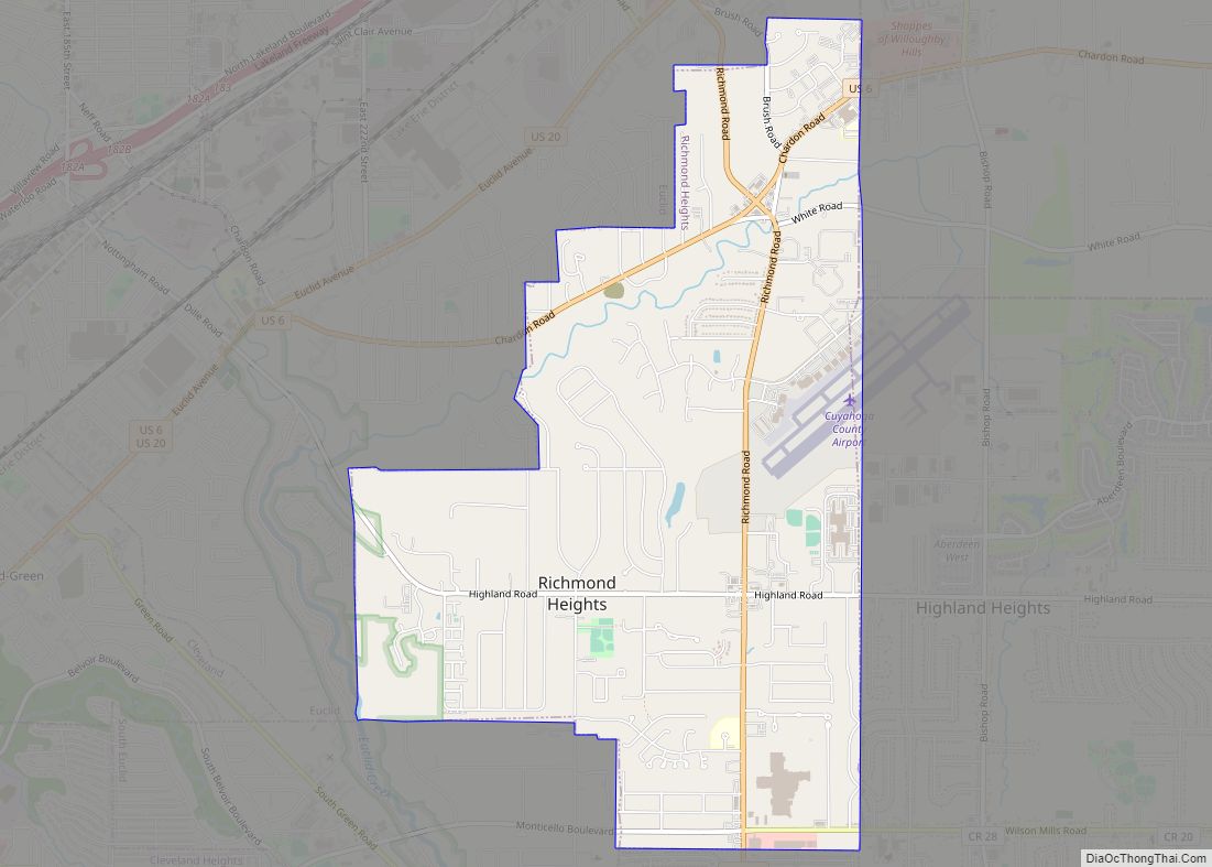
Map of Richfield village, Ohio
Richfield is a village in Summit County, Ohio, United States. The population was 3,648 at the 2010 census. The village and the adjacent Richfield Township are approximately equidistant between the downtown areas of Akron and Cleveland. It is part of the Akron metropolitan area. Richfield is the sister city of Wolfach, Germany. Richfield village overview: ... Read more
Map of Richfield village, Ohio
Map of Reynoldsburg city
Reynoldsburg is a city in Fairfield, Franklin, and Licking counties in the U.S. state of Ohio. It is a suburban community in the Columbus, Ohio metropolitan area. The population was 41,076 at the 2020 census. Reynoldsburg city overview: Name: Reynoldsburg city LSAD Code: 25 LSAD Description: city (suffix) State: Ohio County: Fairfield County, Franklin County, ... Read more
Map of Reynoldsburg city
Map of Republic village, Ohio
Republic is a village in Seneca County, Ohio, United States. The population was 549 at the 2010 census. Republic village overview: Name: Republic village LSAD Code: 47 LSAD Description: village (suffix) State: Ohio County: Seneca County Elevation: 879 ft (268 m) Total Area: 0.86 sq mi (2.23 km²) Land Area: 0.86 sq mi (2.23 km²) Water Area: 0.00 sq mi (0.00 km²) Total Population: 556 Population ... Read more
Map of Republic village, Ohio
Map of Riverside city, Ohio
Riverside is a city in Montgomery County, Ohio, United States. A suburb of Dayton, The population was 24,474 at the 2020 census. It is part of the Dayton Metropolitan Statistical Area. Riverside city overview: Name: Riverside city LSAD Code: 25 LSAD Description: city (suffix) State: Ohio County: Montgomery County Incorporated: January 1, 1995 Elevation: 781 ft ... Read more
Map of Riverside city, Ohio
Map of Riverlea village
Riverlea is a village in Franklin County, Ohio, United States, surrounded by Worthington on its north, south, and east sides, and bordered on the west by the Olentangy River, across which is Columbus. Riverlea was incorporated in 1939, a small community that formed on former farmland. The population was 599 at the 2020 census. In ... Read more
Map of Riverlea village
Map of Rittman city
Rittman is a city in Medina and Wayne counties in the U.S. state of Ohio. All but a small portion of the city is in Wayne County, within commuting distance of Akron, Canton and Cleveland. The population was 6,491 at the 2010 census. Rittman city overview: Name: Rittman city LSAD Code: 25 LSAD Description: city ... Read more
Map of Rittman city
Map of Risingsun village
Risingsun is a village in Wood County, Ohio, United States. The population was 606 at the 2010 census. Risingsun village overview: Name: Risingsun village LSAD Code: 47 LSAD Description: village (suffix) State: Ohio County: Wood County Elevation: 715 ft (218 m) Total Area: 0.57 sq mi (1.48 km²) Land Area: 0.57 sq mi (1.48 km²) Water Area: 0.00 sq mi (0.00 km²) Total Population: 541 Population ... Read more
Map of Risingsun village
Map of Ripley village, Ohio
Ripley is a village in Union Township, Brown County, Ohio, United States, along the Ohio River 50 miles southeast of Cincinnati. The population was 1,750 at the 2010 census. Ripley village overview: Name: Ripley village LSAD Code: 47 LSAD Description: village (suffix) State: Ohio County: Brown County Elevation: 502 ft (153 m) Total Area: 2.29 sq mi (5.94 km²) Land ... Read more
Map of Ripley village, Ohio
Map of Rio Grande village, Ohio
Rio Grande (/ˈraɪoʊ ˈɡrænd/ RY-oh GRAND) is a village in Gallia County, Ohio, United States. The population was 724 at the 2020 census. It is part of the rural Point Pleasant micropolitan area. Although the town is named after the river in the southern United States, its name is pronounced “Rye-O Grand” rather than the ... Read more
Map of Rio Grande village, Ohio
Map of Ridgeway village, Ohio
Ridgeway is a village in Hardin and Logan counties in the U.S. state of Ohio. The population was 338 at the 2010 census. Ridgeway village overview: Name: Ridgeway village LSAD Code: 47 LSAD Description: village (suffix) State: Ohio County: Hardin County, Logan County Elevation: 1,060 ft (320 m) Total Area: 0.57 sq mi (1.46 km²) Land Area: 0.57 sq mi (1.46 km²) Water ... Read more
Map of Ridgeway village, Ohio
Map of Ridgeville Corners CDP
Ridgeville Corners is an unincorporated community and census-designated place (CDP) in southern Ridgeville Township, Henry County, Ohio, United States. It has a post office with the ZIP code 43555. The population was 435 at the 2010 census. Ridgeville Corners CDP overview: Name: Ridgeville Corners CDP LSAD Code: 57 LSAD Description: CDP (suffix) State: Ohio County: ... Read more
Map of Ridgeville Corners CDP
Map of Richwood village, Ohio
Richwood is a village in Union County, Ohio, United States. The population was 2,229 at the 2010 census. Richwood village overview: Name: Richwood village LSAD Code: 47 LSAD Description: village (suffix) State: Ohio County: Union County Elevation: 951 ft (290 m) Total Area: 1.27 sq mi (3.28 km²) Land Area: 1.24 sq mi (3.22 km²) Water Area: 0.03 sq mi (0.07 km²) Total Population: 2,222 Population ... Read more
Map of Richwood village, Ohio