Map of Tontogany village
Tontogany is a village in Wood County, Ohio, United States. The population was 367 at the 2010 census. Tontogany village overview: Name: Tontogany village LSAD Code: 47 LSAD Description: village (suffix) State: Ohio County: Wood County Elevation: 656 ft (200 m) Total Area: 0.30 sq mi (0.79 km²) Land Area: 0.30 sq mi (0.79 km²) Water Area: 0.00 sq mi (0.00 km²) Total Population: 387 Population ... Read more
Map of Tontogany village
Map of Tiro village
Tiro is a village in Crawford County, Ohio, United States. The population was 280 at the 2010 census. Tiro village overview: Name: Tiro village LSAD Code: 47 LSAD Description: village (suffix) State: Ohio County: Crawford County Elevation: 1,053 ft (321 m) Total Area: 0.41 sq mi (1.08 km²) Land Area: 0.41 sq mi (1.08 km²) Water Area: 0.00 sq mi (0.00 km²) Total Population: 219 Population ... Read more
Map of Tiro village
Map of Tuppers Plains CDP
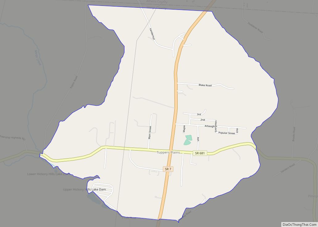
Tuppers Plains is a census-designated place on the boundary of the Olive and Orange townships of Meigs County, Ohio, United States. It includes the small town of Tuppers Plains for which it is named. Tuppers Plains CDP overview: Name: Tuppers Plains CDP LSAD Code: 57 LSAD Description: CDP (suffix) State: Ohio County: Meigs County FIPS ... Read more
Map of Tuppers Plains CDP
Map of Troy city, Ohio
Troy is a city in and the county seat of Miami County, Ohio, United States,19 miles (31 km) north of Dayton. The population was 26,305 at the 2020 census, making it Miami County’s largest city and Ohio’s 55th-largest; it is part of the Dayton Metropolitan Statistical Area. Troy city overview: Name: Troy city LSAD Code: 25 ... Read more
Map of Troy city, Ohio
Map of Trotwood city
Trotwood is a city in Montgomery County, Ohio, United States and is a suburb of Dayton. The population was 23,070 at the 2020 census. It is part of the Dayton Metropolitan Statistical Area. The city is served by the Trotwood-Madison City School District. Trotwood city overview: Name: Trotwood city LSAD Code: 25 LSAD Description: city ... Read more
Map of Trotwood city
Map of Trinway CDP
Trinway is an unincorporated community and census-designated place in northern Cass Township, Muskingum County, Ohio, United States, in the east-central part of the state. The village is 52 miles east of the state capital of Columbus and near the town of Dresden. Trinway is a rural community of mostly residential architecture. Trinway CDP overview: Name: ... Read more
Map of Trinway CDP
Map of Trimble village, Ohio
Trimble is a village in Trimble Township, Athens County, Ohio, United States. The population was 329 at the 2020 census. Trimble village overview: Name: Trimble village LSAD Code: 47 LSAD Description: village (suffix) State: Ohio County: Athens County Elevation: 663 ft (202 m) Total Area: 0.69 sq mi (1.79 km²) Land Area: 0.68 sq mi (1.76 km²) Water Area: 0.01 sq mi (0.03 km²) Total Population: ... Read more
Map of Trimble village, Ohio
Map of Uniopolis CDP
Uniopolis is an unincorporated community and former village in Auglaize County, Ohio, United States. The population was 222 at the 2010 census. It is included in the Wapakoneta, Ohio Micropolitan Statistical Area. The community is served by the Wapakoneta City School District. Uniopolis CDP overview: Name: Uniopolis CDP LSAD Code: 57 LSAD Description: CDP (suffix) ... Read more
Map of Uniopolis CDP
Map of Unionville Center village
Unionville Center is a village in Union County, Ohio, in the United States. The population was 233 at the 2010 census. The village is home to the Charles W. Fairbanks Festival that is held each May. The village also supports a post office, with the ZIP Code of 43077. Unionville Center village overview: Name: Unionville ... Read more
Map of Unionville Center village
Map of Uniontown CDP, Ohio
Uniontown is a census-designated place (CDP) in Stark County, Ohio, United States with 3,309 inhabitants at the 2010 census. The Industrial Excess Landfill, now a superfund site, is located south of Uniontown. Uniontown is part of the Canton-Massillon, OH Metropolitan Statistical Area. Uniontown CDP overview: Name: Uniontown CDP LSAD Code: 57 LSAD Description: CDP (suffix) ... Read more
Map of Uniontown CDP, Ohio
Map of Union city, Ohio
Union is a city in Montgomery and Miami Counties in the U.S. state of Ohio. The population was 6,859 at the time of the 2020 census. It is part of the Dayton Metropolitan Statistical Area. Union city overview: Name: Union city LSAD Code: 25 LSAD Description: city (suffix) State: Ohio County: Miami County, Montgomery County ... Read more
Map of Union city, Ohio
Map of Union City village, Ohio
Union City is a village in Darke County, Ohio, United States. The population was 1,666 at the 2010 census. It is directly across the state line from its twin city of Union City, Indiana. It has a 24/7 police and fire department run by Police and Fire Chief Mark S. Ater Jr. Union City village ... Read more
Map of Union City village, Ohio