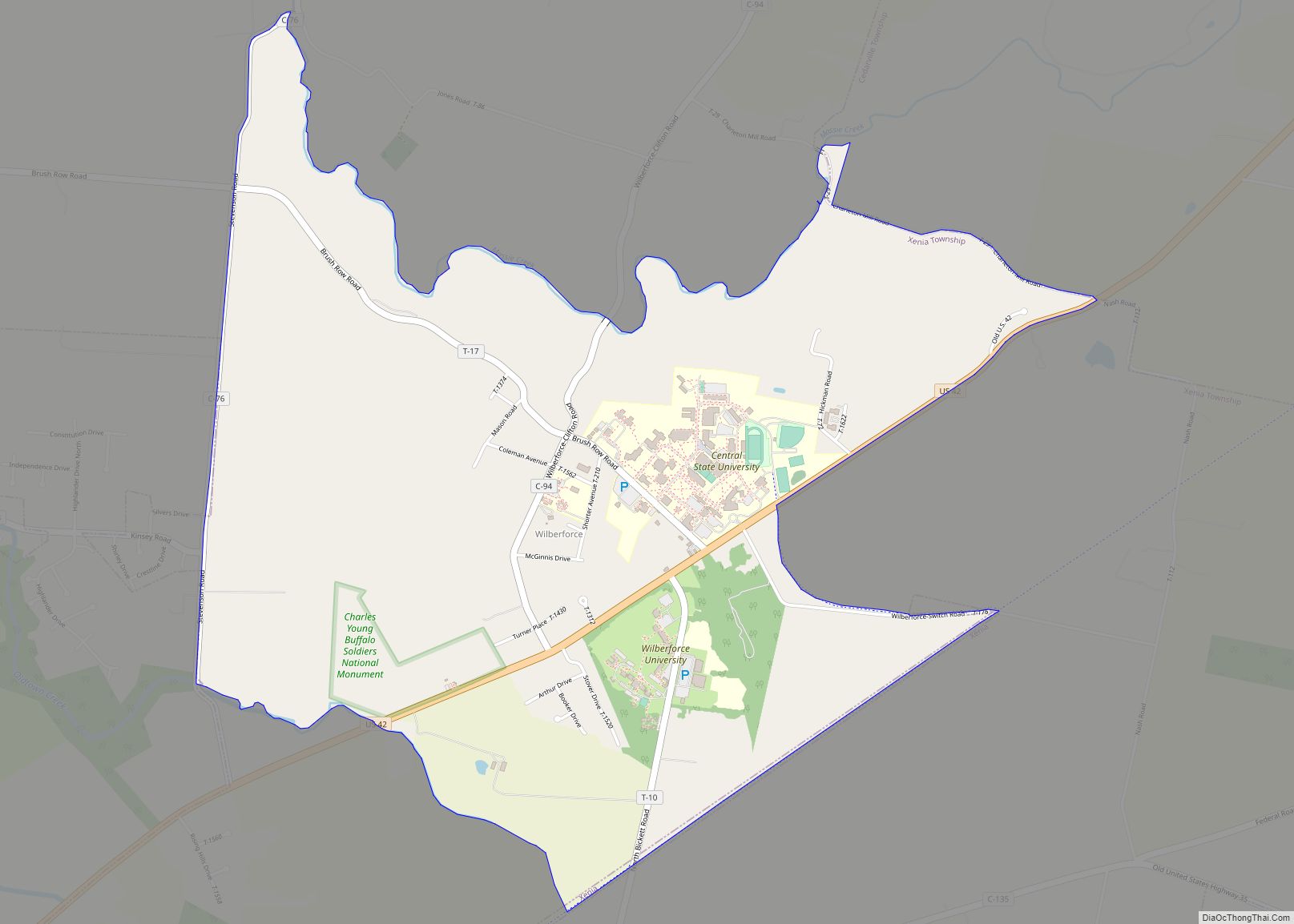
Map of White Oak CDP, Ohio

Map of White Oak CDP, Ohio

White Oak is a census-designated place (CDP) in Hamilton County, Ohio, United States. It is seven miles northwest of Cincinnati. The population was 19,541 at the 2020 census. White Oak is situated in both Green Township and Colerain Township. White Oak CDP overview: Name: White Oak CDP LSAD Code: 57 LSAD Description: CDP (suffix) State: … Read more

Map of Willowick city

Map of Willowick city

Willowick is a city in Lake County, Ohio, United States, on Lake Erie. The population was 14,204 at the 2020 census. A suburb of Cleveland, Willowick is served by a branch of the Willoughby-Eastlake Public Library. The city’s name is a portmanteau of two adjacent cities, Willoughby and Wickliffe. As of 2022, the mayor of … Read more

Map of Willoughby city

Map of Willoughby city

Willoughby is a city in Lake County, Ohio, United States, along the Chagrin River. The population was 23,959 at the time of the 2020 census. A suburb of Cleveland, it is part of the Cleveland metropolitan area. Willoughby city overview: Name: Willoughby city LSAD Code: 25 LSAD Description: city (suffix) State: Ohio County: Lake County … Read more

Map of Willoughby Hills city

Map of Willoughby Hills city

Willoughby Hills is a city in Lake County, Ohio, United States, along the Chagrin River. The population was 10,019 at the 2020 census. A suburb of Cleveland, it is part of the Cleveland metropolitan area. Willoughby Hills city overview: Name: Willoughby Hills city LSAD Code: 25 LSAD Description: city (suffix) State: Ohio County: Lake County … Read more

Map of Williston CDP, Ohio

Map of Williston CDP, Ohio

Williston is an unincorporated community and census-designated place in northern Allen Township, Ottawa County, Ohio, United States, located along State Route 579. It is located in the northwestern part of the state, near Toledo. Its ZIP code is 43468. Its population was 211 people, according to the 2000 Census. The town received regional attention with … Read more

Map of Williamsport village, Ohio

Map of Williamsport village, Ohio

Williamsport is a village in Pickaway County, Ohio, United States. The population was 1,023 at the 2010 census. Williamsport village overview: Name: Williamsport village LSAD Code: 47 LSAD Description: village (suffix) State: Ohio County: Pickaway County Total Area: 1.80 sq mi (4.67 km²) Land Area: 1.77 sq mi (4.60 km²) Water Area: 0.03 sq mi (0.08 km²) Total Population: 970 Population Density: 546.48/sq mi (210.97/km²) … Read more

Map of Williamsdale CDP

Map of Williamsdale CDP

Williamsdale is a census-designated place (CDP) in St. Clair Township, Butler County, Ohio, United States. The population was 581 at the 2010 census. Williamsdale CDP overview: Name: Williamsdale CDP LSAD Code: 57 LSAD Description: CDP (suffix) State: Ohio County: Butler County Elevation: 600 ft (200 m) Total Area: 0.17 sq mi (0.45 km²) Land Area: 0.17 sq mi (0.45 km²) Water Area: 0.00 sq mi … Read more

Map of Williamsburg village, Ohio

Map of Williamsburg village, Ohio

Williamsburg is a village in Clermont County, Ohio, United States. The population was 2,570 at the 2020 census. Williamsburg village overview: Name: Williamsburg village LSAD Code: 47 LSAD Description: village (suffix) State: Ohio County: Clermont County Total Area: 2.59 sq mi (6.72 km²) Land Area: 2.56 sq mi (6.63 km²) Water Area: 0.04 sq mi (0.09 km²) Total Population: 2,570 Population Density: 1,004.30/sq mi (387.77/km²) … Read more

Map of Willard city, Ohio

Map of Willard city, Ohio

Willard is a city in southwestern Huron County, Ohio, United States, approximately 14 miles (23 km) southwest of Norwalk. The population was 6,236 at the 2010 census. Willard city overview: Name: Willard city LSAD Code: 25 LSAD Description: city (suffix) State: Ohio County: Huron County Elevation: 928 ft (283 m) Total Area: 3.60 sq mi (9.33 km²) Land Area: 3.58 sq mi (9.27 km²) … Read more

Map of Wilkesville village

Map of Wilkesville village

Wilkesville is a village in Vinton County, Ohio, United States. The population was 149 at the 2010 census. Wilkesville village overview: Name: Wilkesville village LSAD Code: 47 LSAD Description: village (suffix) State: Ohio County: Vinton County Total Area: 0.26 sq mi (0.67 km²) Land Area: 0.26 sq mi (0.67 km²) Water Area: 0.00 sq mi (0.00 km²) Total Population: 116 Population Density: 447.88/sq mi (173.10/km²) … Read more

Map of Willshire village

Map of Willshire village

Willshire is a village in Van Wert County, Ohio, United States. The population was 397 at the 2010 census. It is included within the Van Wert, Ohio Micropolitan Statistical Area. Willshire is located 0.5 mi (0.8 km) from the Ohio/Indiana State line. St. Mary’s River flows along the east edge of village. Willshire village overview: Name: Willshire … Read more

Map of Woodlawn village, Ohio

Map of Woodlawn village, Ohio

Woodlawn is a village in Hamilton County, Ohio, United States. The population was 3,916 at the 2020 census. Woodlawn village overview: Name: Woodlawn village LSAD Code: 47 LSAD Description: village (suffix) State: Ohio County: Hamilton County Total Area: 2.56 sq mi (6.62 km²) Land Area: 2.56 sq mi (6.62 km²) Water Area: 0.00 sq mi (0.00 km²) Total Population: 3,916 Population Density: 1,532.68/sq mi (591.66/km²) … Read more