Map of Cedar Crest CDP, Oklahoma

Map of Cedar Crest CDP, Oklahoma

Cedar Crest is a census-designated place (CDP) in Mayes County, Oklahoma, United States. The population was 312 at the 2010 census, almost unchanged from the figure of 308 recorded in 2000. Cedar Crest CDP overview: Name: Cedar Crest CDP LSAD Code: 57 LSAD Description: CDP (suffix) State: Oklahoma County: Mayes County Elevation: 659 ft (201 m) Total … Read more

Map of Cayuga CDP, Oklahoma

Map of Cayuga CDP, Oklahoma

Cayuga Springs is an unincorporated community and census-designated place (CDP) in Delaware County, Oklahoma, United States. The population was 140 at the 2010 census, a 33.3 percent increase over the figure of 105 recorded in 2000. It was established on the Elk River in the old Seneca Reserve in Indian Territory. The Cayuga Springs Post … Read more

Map of Catoosa city

Map of Catoosa city

Catoosa is a city in Rogers and Wagoner counties in the U.S. state of Oklahoma. The population was 7,159 at the 2010 census compared to 5,449 at the 2000 census. This was a 31.2 percent increase during the decade. Catoosa city overview: Name: Catoosa city LSAD Code: 25 LSAD Description: city (suffix) State: Oklahoma County: … Read more

Map of Castle town

Map of Castle town

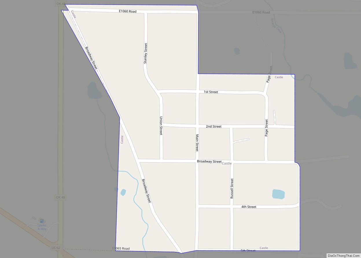
Castle is a town in Okfuskee County, Oklahoma, United States. A post office was established February 25, 1903, and the town was named for the first postmaster, Manford B. Castle. The population was 106 at the 2010 census. Castle town overview: Name: Castle town LSAD Code: 43 LSAD Description: town (suffix) State: Oklahoma County: Okfuskee … Read more

Map of Cashion town

Map of Cashion town

Cashion is a town in Kingfisher and Logan counties in the U.S. state of Oklahoma. The Logan County portion of Cashion is part of the Oklahoma City Metropolitan Statistical Area. The town population was 802 at the 2010 census, up from 643 in 2000. Cashion town overview: Name: Cashion town LSAD Code: 43 LSAD Description: … Read more

Map of Cartwright CDP

Map of Cartwright CDP

Cartwright is an unincorporated rural community and census-designated place in Bryan County, Oklahoma, United States. As of the 2010 census it had a population of 609. The post office opened April 25, 1940, and it is one of the newest communities in Bryan County. The ZIP code is 74731. It is named for Congressman Wilburn … Read more

Map of Cherry Tree CDP

Map of Cherry Tree CDP, Oklahoma

Cherry Tree is a census-designated place (CDP) in Adair County, Oklahoma, United States. The population was 883 at the 2010 census, a decline of 26.5 percent from the figure of 1,202 recorded in 2000. Cherry Tree CDP overview: Name: Cherry Tree CDP LSAD Code: 57 LSAD Description: CDP (suffix) State: Oklahoma County: Adair County Elevation: … Read more

Map of Cherokee city, Oklahoma

Map of Cherokee city, Oklahoma

Cherokee is the largest city within, and county seat of, Alfalfa County, Oklahoma, United States. The population was 1,476 at the 2020 census, a decline of 1.5 percent from 2010. Cherokee city overview: Name: Cherokee city LSAD Code: 25 LSAD Description: city (suffix) State: Oklahoma County: Alfalfa County Elevation: 1,181 ft (360 m) Total Area: 2.04 sq mi (5.29 km²) … Read more

Map of Chelsea town, Oklahoma

Map of Chelsea town, Oklahoma

Chelsea is a town in Rogers County, Oklahoma, United States. The population was 1,964 at the 2010 census, a decline of 8.3 percent from the figure of 2,136 recorded in 2000. Chelsea was named after the area in London, England, by Charles Peach, a railroad official who was a native of London. The town was … Read more

Map of Checotah city

Map of Checotah city

Checotah is a town in McIntosh County, Oklahoma, United States. It was named for Samuel Checote, the first chief of the Creek Nation elected after the Civil War. Its population was 3,481 at the 2000 census. According to Census 2010, the population has decreased to 3,335; a 4.19% loss. Checotah is home to numerous antique … Read more

Map of Chattanooga city

Map of Chattanooga town, Oklahoma

Chattanooga is a town in Comanche and Tillman counties in the U.S. state of Oklahoma. It is located on Oklahoma State Highway 36 about 23.7 driving miles southwest of Lawton. The population was 461 at the 2010 census. The Comanche County portion of Chattanooga is included in the Lawton, Oklahoma Metropolitan Statistical Area. Chattanooga town … Read more

Map of Chandler city, Oklahoma

Map of Chandler city, Oklahoma

Chandler (Meskwaki: Chêninêheki) is a city in, and the county seat of, Lincoln County, Oklahoma, United States. and is part of the Oklahoma City Metropolitan Area. The population was 3,100 at the 2010 census, an increase over the figure of 2,842 in 2000. Chandler is located northeast of Oklahoma City on SH-66 and I-44, and … Read more