Map of Fairland town, Oklahoma
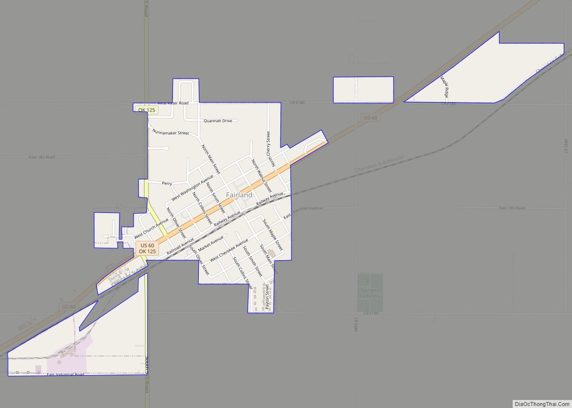
Fairland is a town in southern Ottawa County, Oklahoma, United States. The population was 1,057 at the 2010 U. S. Census, an increase from the figure of 1,025 recorded in 2000. The town is in the historic Cherokee Nation. Fairland town overview: Name: Fairland town LSAD Code: 43 LSAD Description: town (suffix) State: Oklahoma County: ... Read more
Map of Fairland town, Oklahoma
Map of Fairfield CDP, Oklahoma
Fairfield is a census-designated place (CDP) in Adair County, Oklahoma, United States. The population was 584 at the 2010 census. Fairfield CDP overview: Name: Fairfield CDP LSAD Code: 57 LSAD Description: CDP (suffix) State: Oklahoma County: Adair County Total Area: 4.98 sq mi (12.89 km²) Land Area: 4.96 sq mi (12.85 km²) Water Area: 0.01 sq mi (0.04 km²) Total Population: 626 Population Density: ... Read more
Map of Fairfield CDP, Oklahoma
Map of Fairfax town, Oklahoma
Fairfax is a town in Osage County, Oklahoma, United States. The Osage Nation reservation is coterminous with the county. The population was 1,380 at the 2010 census, down 11.3 percent from the figure of 1,555 recorded in 2000. It is notable as the home of world-famous ballerinas Maria and Marjorie Tallchief. Fairfax town overview: Name: ... Read more
Map of Fairfax town, Oklahoma
Map of Fair Oaks town, Oklahoma
Fair Oaks is a town in Rogers and Wagoner counties in the U.S. state of Oklahoma. The population was 103 at the 2010 census, a 15.6 percent decline from the figure of 122 recorded in 2000. It is a suburb of Tulsa. Fair Oaks town overview: Name: Fair Oaks town LSAD Code: 43 LSAD Description: ... Read more
Map of Fair Oaks town, Oklahoma
Map of Evening Shade CDP, Oklahoma
Evening Shade is a census-designated place (CDP) in Sequoyah County, Oklahoma, United States. It is part of the Fort Smith, Arkansas-Oklahoma Metropolitan Statistical Area. The population was 359 at the 2010 census. Evening Shade CDP overview: Name: Evening Shade CDP LSAD Code: 57 LSAD Description: CDP (suffix) State: Oklahoma County: Sequoyah County Total Area: 13.36 sq mi ... Read more
Map of Evening Shade CDP, Oklahoma
Map of Eufaula city, Oklahoma
Eufaula is a city and county seat of McIntosh County, Oklahoma, United States. The population was 2,813 at the 2010 census, an increase of 6.6 percent from 2,639 in 2000. Eufaula is in the southern part of the county, 30 miles (48 km) north of McAlester and 32 miles (51 km) south of Muskogee. The name “Eufaula” ... Read more
Map of Eufaula city, Oklahoma
Map of Etowah town, Oklahoma
Etowah is a town in Cleveland County, Oklahoma, United States. The population was 159 at the 2020 census, a 72.8% increase from 2010. Etowah town overview: Name: Etowah town LSAD Code: 43 LSAD Description: town (suffix) State: Oklahoma County: Cleveland County Elevation: 1,096 ft (334 m) Total Area: 1.99 sq mi (5.16 km²) Land Area: 1.99 sq mi (5.15 km²) Water Area: 0.00 sq mi ... Read more
Map of Etowah town, Oklahoma
Map of Erin Springs town
Erin Springs town overview: Name: Erin Springs town LSAD Code: 43 LSAD Description: town (suffix) State: Oklahoma County: Garvin County FIPS code: 4024300 Online Interactive Map Erin Springs online map. Source: Basemap layers from Google Map, Open Street Map (OSM), Arcgisonline, Wmflabs. Boundary Data from Database of Global Administrative Areas. Erin Springs location map. Where ... Read more
Map of Erin Springs town
Map of Foraker town
Foraker is a town in Osage County, Oklahoma, United States. It was named for Ohio Senator Joseph B. Foraker. The Tallgrass Prairie Preserve is southeast of town. The official population peaked at 415 in 1910 and has declined steadily since 1930. The population was only 18 at the 2010 census, a 21.7 percent decline from ... Read more
Map of Foraker town
Map of Flute Springs CDP
Flute Springs is a census-designated place (CDP) in Sequoyah County, Oklahoma, United States. It is part of the Fort Smith, Arkansas-Oklahoma Metropolitan Statistical Area. The population was 182 at the 2000 census. Flute Springs CDP overview: Name: Flute Springs CDP LSAD Code: 57 LSAD Description: CDP (suffix) State: Oklahoma County: Sequoyah County Total Area: 4.39 sq mi ... Read more
Map of Flute Springs CDP
Map of Flint Creek CDP
Flint Creek is an unincorporated area and census-designated place (CDP) in Delaware County, Oklahoma, United States. The population was 732 at the 2010 census, up from 580 in 2000. Flint Creek CDP overview: Name: Flint Creek CDP LSAD Code: 57 LSAD Description: CDP (suffix) State: Oklahoma County: Delaware County Elevation: 1,100 ft (300 m) Total Area: 6.37 sq mi ... Read more
Map of Flint Creek CDP
Map of Fletcher town, Oklahoma
Fletcher is a town in Comanche County, Oklahoma, United States. The population was 1,177 at the 2010 census. It is included in the Lawton, Oklahoma Metropolitan Statistical Area. Fletcher town overview: Name: Fletcher town LSAD Code: 43 LSAD Description: town (suffix) State: Oklahoma County: Comanche County Elevation: 1,381 ft (421 m) Total Area: 1.94 sq mi (5.01 km²) Land Area: ... Read more
Map of Fletcher town, Oklahoma