Map of Gould town, Oklahoma
Gould is a town in Harmon County, Oklahoma, United States. The population was 141 at the 2010 census. Gould town overview: Name: Gould town LSAD Code: 43 LSAD Description: town (suffix) State: Oklahoma County: Harmon County Elevation: 1,631 ft (497 m) Total Area: 0.36 sq mi (0.94 km²) Land Area: 0.36 sq mi (0.94 km²) Water Area: 0.00 sq mi (0.00 km²) Total Population: 103 Population ... Read more
Map of Gould town, Oklahoma
Map of Gotebo town
Gotebo /ˈɡoʊtɪboʊ/ is a town in Kiowa County, Oklahoma, United States. The population was 226 at the 2010 census, a decline of 16.9 percent from 272 in 2000. The town is named after the notable Kiowa Indian named Gotebo (1847 – 1927) (in Kiowa, [kʼóːdebõhõn]). Gotebo town overview: Name: Gotebo town LSAD Code: 43 LSAD ... Read more
Map of Gotebo town
Map of Grant CDP, Oklahoma
Grant is an unincorporated community in Choctaw County, Oklahoma, United States. It is located along U.S. Route 271, south of Hugo. As of the 2010 census it had a population of 289. Grant CDP overview: Name: Grant CDP LSAD Code: 57 LSAD Description: CDP (suffix) State: Oklahoma County: Choctaw County Elevation: 465 ft (142 m) Total Area: ... Read more
Map of Grant CDP, Oklahoma
Map of Granite town, Oklahoma
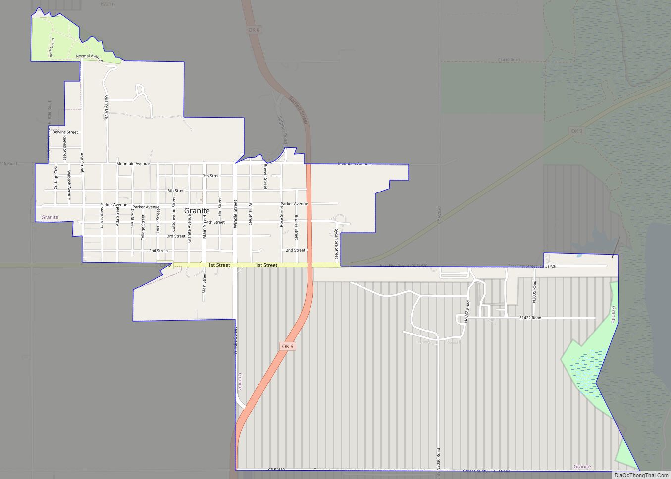
Granite is a town in Greer County, Oklahoma, United States. The population was 1,628 at the 2020 census. Granite town overview: Name: Granite town LSAD Code: 43 LSAD Description: town (suffix) State: Oklahoma County: Greer County Elevation: 1,611 ft (491 m) Total Area: 3.39 sq mi (8.77 km²) Land Area: 3.37 sq mi (8.73 km²) Water Area: 0.01 sq mi (0.04 km²) Total Population: 1,628 Population ... Read more
Map of Granite town, Oklahoma
Map of Grandview CDP, Oklahoma
Grandview is an unincorporated area and census-designated place (CDP) in Cherokee County, Oklahoma, United States. The population was 394 at the 2010 census. Grandview CDP overview: Name: Grandview CDP LSAD Code: 57 LSAD Description: CDP (suffix) State: Oklahoma County: Cherokee County Elevation: 987 ft (301 m) Total Area: 7.06 sq mi (18.28 km²) Land Area: 7.05 sq mi (18.27 km²) Water Area: 0.00 sq mi ... Read more
Map of Grandview CDP, Oklahoma
Map of Grandfield city
Grandfield is a city in Tillman County, Oklahoma, United States. The population was 1,038 at the 2010 census. Grandfield city overview: Name: Grandfield city LSAD Code: 25 LSAD Description: city (suffix) State: Oklahoma County: Tillman County Elevation: 1,132 ft (345 m) Total Area: 0.83 sq mi (2.16 km²) Land Area: 0.83 sq mi (2.16 km²) Water Area: 0.00 sq mi (0.00 km²) Total Population: 919 Population ... Read more
Map of Grandfield city
Map of Grand Lake Towne town
Grand Lake Towne is a town in Mayes County, Oklahoma, United States. The population was 74 at the 2010 census. Grand Lake Towne town overview: Name: Grand Lake Towne town LSAD Code: 43 LSAD Description: town (suffix) State: Oklahoma County: Mayes County Elevation: 794 ft (242 m) Total Area: 0.13 sq mi (0.35 km²) Land Area: 0.13 sq mi (0.35 km²) Water Area: ... Read more
Map of Grand Lake Towne town
Map of Grainola town
Grainola is a town in northwest Osage County, Oklahoma, United States. The population was 31 at the 2010 census, a figure which was unchanged from 2000. The main industry of the area is cattle ranching. The town name was invented in March 1910. Grainola town overview: Name: Grainola town LSAD Code: 43 LSAD Description: town ... Read more
Map of Grainola town
Map of Gracemont town
Gracemont is a town in Caddo County, Oklahoma, United States. The population was 318 at the 2010 census. The town name is a portmanteau of Grace and Montgomery, the names of two friends of the first postmaster, Alice L. Bailey. Gracemont town overview: Name: Gracemont town LSAD Code: 43 LSAD Description: town (suffix) State: Oklahoma ... Read more
Map of Gracemont town
Map of Gowen CDP
Gowen CDP overview: Name: Gowen CDP LSAD Code: 57 LSAD Description: CDP (suffix) State: Oklahoma FIPS code: 4030500 Online Interactive Map Gowen online map. Source: Basemap layers from Google Map, Open Street Map (OSM), Arcgisonline, Wmflabs. Boundary Data from Database of Global Administrative Areas. Gowen location map. Where is Gowen CDP? Gowen Road Map Gowen ... Read more
Map of Gowen CDP
Map of Haileyville city
Haileyville is a city in Pittsburg County, Oklahoma, United States. The population was 813 at the 2010 census. Haileyville city overview: Name: Haileyville city LSAD Code: 25 LSAD Description: city (suffix) State: Oklahoma County: Pittsburg County Elevation: 633 ft (193 m) Total Area: 1.04 sq mi (2.68 km²) Land Area: 1.03 sq mi (2.68 km²) Water Area: 0.00 sq mi (0.01 km²) Total Population: 716 Population ... Read more
Map of Haileyville city
Map of Guymon city
Guymon (/ˈɡaɪmən/ GHY-mən) is a city and county seat of Texas County, in the panhandle of Oklahoma, United States. As of the 2020 census, the city population was 12,965, an increase of 13.3% from 11,442 in 2010, and represents more than half of the population of the county. Cattle feedlots, corporate pork farms, and natural ... Read more
Map of Guymon city