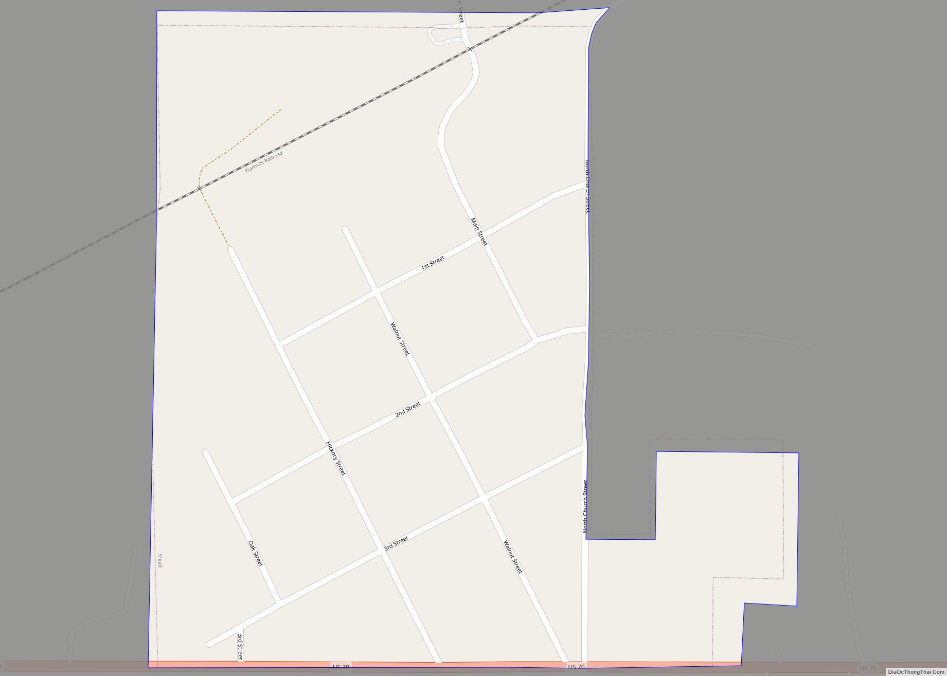
Map of Miami city, Oklahoma
Miami (/maɪˈæmə/ my-AM-ə) is a city in and county seat of Ottawa County, Oklahoma, United States, founded in 1891. Lead and zinc mining were established by 1918, causing the area’s economy to boom. This area was part of Indian Territory. Miami is the capital of the federally recognized Miami Tribe of Oklahoma, after which it ... Read more
Map of Miami city, Oklahoma
Map of Meridian CDP, Oklahoma
Meridian is a former census-designated place (CDP) in Stephens County, Oklahoma, United States. The population was 1,485 at the 2000 census. As of the 2020 census, the area, plus land to the north, was part of the Sunray CDP. Meridian CDP overview: Name: Meridian CDP LSAD Code: 57 LSAD Description: CDP (suffix) State: Oklahoma County: ... Read more
Map of Meridian CDP, Oklahoma
Map of Meno town
Meno is a town in Major County, Oklahoma, United States. The population was 235 at the 2010 census, a 20.5 percent increase from the figure of 195 in 2000. Meno town overview: Name: Meno town LSAD Code: 43 LSAD Description: town (suffix) State: Oklahoma County: Major County Elevation: 1,345 ft (410 m) Total Area: 0.19 sq mi (0.50 km²) Land ... Read more
Map of Meno town
Map of Meeker town, Oklahoma
Meeker is a town in Lincoln County, Oklahoma, United States. The population was 1,145 at the 2010 census. Meeker town overview: Name: Meeker town LSAD Code: 43 LSAD Description: town (suffix) State: Oklahoma County: Lincoln County Elevation: 896 ft (273 m) Total Area: 3.01 sq mi (7.80 km²) Land Area: 2.94 sq mi (7.62 km²) Water Area: 0.07 sq mi (0.18 km²) Total Population: 1,004 Population ... Read more
Map of Meeker town, Oklahoma
Map of Morris city, Oklahoma
Morris is a city in Okmulgee County, Oklahoma, United States. The population was 1,494 at the 2010 census, an increase of 14.3% from the figure of 1,294 recorded in 2000. Morris city overview: Name: Morris city LSAD Code: 25 LSAD Description: city (suffix) State: Oklahoma County: Okmulgee County Elevation: 722 ft (220 m) Total Area: 1.27 sq mi (3.30 km²) ... Read more
Map of Morris city, Oklahoma
Map of Mooreland town, Oklahoma
Mooreland is a town in Woodward County, Oklahoma, United States, 10 miles (16 km) east of the city of Woodward, the county seat. The population was 1,190 at the 2010 census. Mooreland lies in a valley approximately 5 miles (8.0 km) north of the North Canadian River. This area of shallow-water land lies at an altitude of ... Read more
Map of Mooreland town, Oklahoma
Map of Moore city, Oklahoma
Moore is a city in Cleveland County, Oklahoma, United States, and is part of the Oklahoma City metropolitan area. The population was 62,793 at the 2020 census, making Moore the seventh-largest city in the state of Oklahoma. Located between Oklahoma City and Norman, the city has been the site of several devastating tornadoes, with those ... Read more
Map of Moore city, Oklahoma
Map of Monroe CDP, Oklahoma
Monroe CDP overview: Name: Monroe CDP LSAD Code: 57 LSAD Description: CDP (suffix) State: Oklahoma FIPS code: 4049050 Online Interactive Map Monroe online map. Source: Basemap layers from Google Map, Open Street Map (OSM), Arcgisonline, Wmflabs. Boundary Data from Database of Global Administrative Areas. Monroe location map. Where is Monroe CDP? Monroe Road Map Monroe ... Read more
Map of Monroe CDP, Oklahoma
Map of Moffett town
Moffett is a town in Sequoyah County, Oklahoma, United States. It is part of the Fort Smith, Arkansas-Oklahoma Metropolitan Statistical Area. The population was 128 at the 2010 census, a decline of 28.5 percent from the figure of 179 recorded in 2000. Moffett town overview: Name: Moffett town LSAD Code: 43 LSAD Description: town (suffix) ... Read more
Map of Moffett town
Map of Minco city
Minco is a city in Grady County, Oklahoma, United States. The population was 1,500 at the 2020 census, a 8.1% decrease from 2010. Minco city overview: Name: Minco city LSAD Code: 25 LSAD Description: city (suffix) State: Oklahoma County: Grady County Elevation: 1,296 ft (395 m) Total Area: 12.31 sq mi (31.88 km²) Land Area: 12.28 sq mi (31.79 km²) Water Area: 0.04 sq mi ... Read more
Map of Minco city
Map of Millerton town, Oklahoma
Millerton is a town in McCurtain County, Oklahoma, United States. The population was 359 at the 2000 census. The oldest church building in Oklahoma, Wheelock Church, is located near Millerton. Millerton town overview: Name: Millerton town LSAD Code: 43 LSAD Description: town (suffix) State: Oklahoma County: McCurtain County Elevation: 505 ft (154 m) Total Area: 1.63 sq mi (4.22 km²) ... Read more
Map of Millerton town, Oklahoma
Map of Mill Creek town, Oklahoma
Mill Creek is a town in Johnston County, Oklahoma, United States. The population was 319 at the 2010 census, a decline from the figure of 340 in 2000. Mill Creek Community is an unincorporated area of Johnston County that surrounds the town and claims to have about 1,000 residents, including those who live within the ... Read more
Map of Mill Creek town, Oklahoma