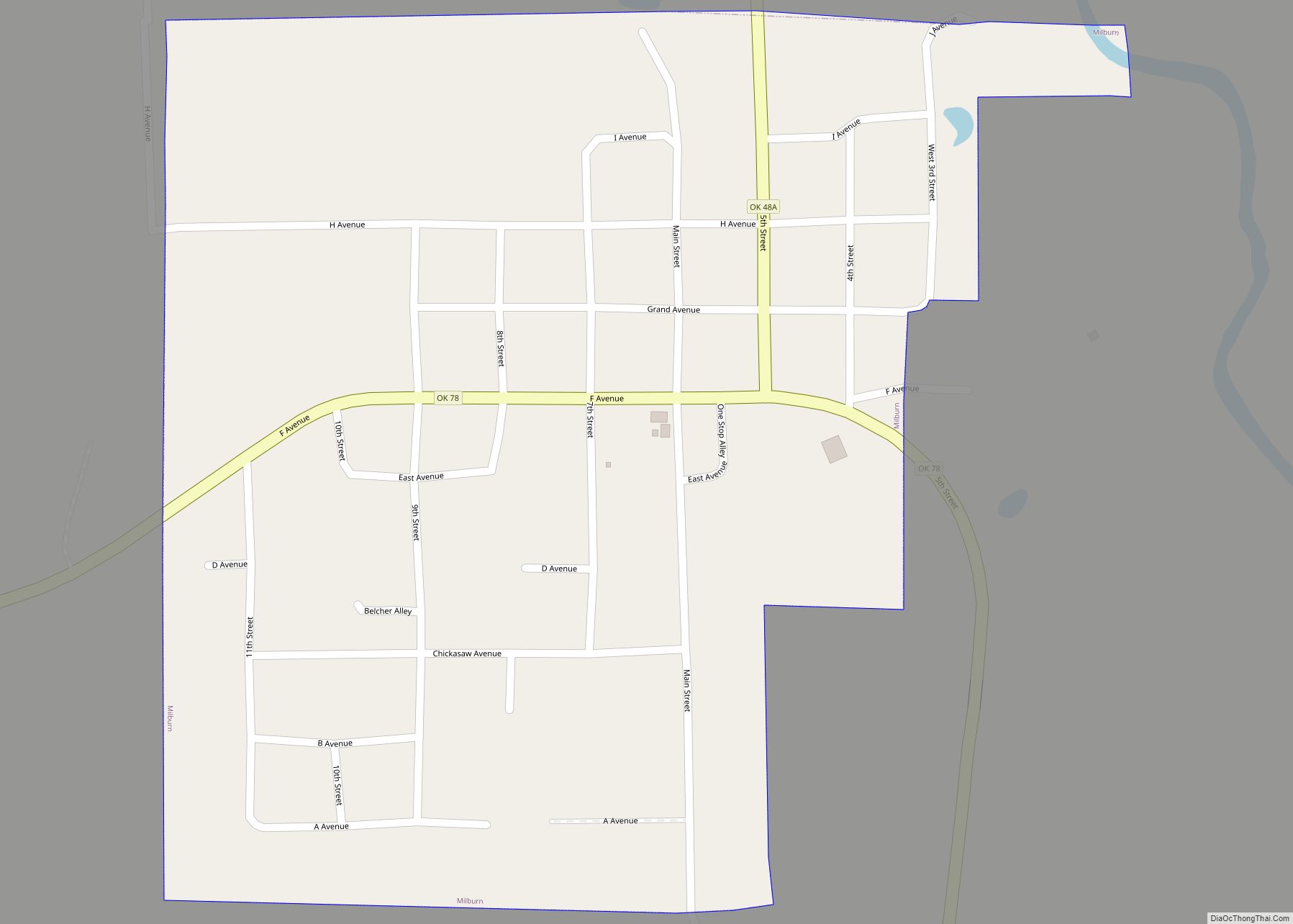
Map of Moore city, Oklahoma

Map of Moore city, Oklahoma

Moore is a city in Cleveland County, Oklahoma, United States, and is part of the Oklahoma City metropolitan area. The population was 62,793 at the 2020 census, making Moore the seventh-largest city in the state of Oklahoma. Located between Oklahoma City and Norman, the city has been the site of several devastating tornadoes, with those … Read more

Map of Monroe CDP, Oklahoma

Map of Monroe CDP, Oklahoma

Monroe CDP overview: Name: Monroe CDP LSAD Code: 57 LSAD Description: CDP (suffix) State: Oklahoma FIPS code: 4049050 Online Interactive Map Monroe online map. Source: Basemap layers from Google Map, Open Street Map (OSM), Arcgisonline, Wmflabs. Boundary Data from Database of Global Administrative Areas. Monroe location map. Where is Monroe CDP? Monroe Road Map Monroe … Read more

Map of Mustang city

Map of Mustang city, Oklahoma

Mustang is a city in the southeastern corner of Canadian County, Oklahoma, United States. It is part of the Oklahoma City metropolitan statistical area. Mustang’s population was 19,879 at the 2020 census, a 14.3% increase from 17,398 in 2010. The city is now primarily known as a bedroom community for Oklahoma City. Mustang city overview: … Read more

Map of Muskogee city

Map of Muskogee city

Muskogee (/məˈskoʊɡiː/) is the thirteenth-largest city in Oklahoma and the county seat of Muskogee County. Home to Bacone College, it lies approximately 48 miles (77 km) southeast of Tulsa. The population of the city was 36,878 as of the 2020 census, a 6.0 percent decrease from 39,223 in 2010. Muskogee city overview: Name: Muskogee city LSAD … Read more

Map of Murphy CDP, Oklahoma

Map of Murphy CDP, Oklahoma

Murphy is a census-designated place (CDP) in Mayes County, Oklahoma, United States. The population was 231 at the 2000 census. Murphy CDP overview: Name: Murphy CDP LSAD Code: 57 LSAD Description: CDP (suffix) State: Oklahoma County: Mayes County Elevation: 597 ft (182 m) Total Area: 4.12 sq mi (10.68 km²) Land Area: 4.12 sq mi (10.68 km²) Water Area: 0.00 sq mi (0.00 km²) Total Population: … Read more

Map of Mulhall town

Map of Mulhall town

Mulhall is a town in Logan (mostly) and Payne counties in Oklahoma, United States. The population was 225 at the 2010 census, down 5.9 percent from the figure of 239 in 2000. It is part of the Oklahoma City Metropolitan Statistical Area. Mulhall town overview: Name: Mulhall town LSAD Code: 43 LSAD Description: town (suffix) … Read more

Map of Muldrow town

Map of Muldrow town

Muldrow is a town in Sequoyah County, Oklahoma, United States. It is part of the Fort Smith, Arkansas-Oklahoma Metropolitan Statistical Area. The population was 3,466 at the 2010 census, an increase of 11.7 percent over the figure of 3,104 recorded in 2000. The town was named in honor of Henry L. Muldrow, a U.S. Representative … Read more

Map of Mulberry CDP, Oklahoma

Map of Mulberry CDP, Oklahoma

Mulberry is a census-designated place (CDP) in Adair County, Oklahoma, United States. The population was 138 at the 2010 census. Mulberry CDP overview: Name: Mulberry CDP LSAD Code: 57 LSAD Description: CDP (suffix) State: Oklahoma County: Adair County Elevation: 1,000 ft (300 m) Total Area: 0.94 sq mi (2.42 km²) Land Area: 0.93 sq mi (2.42 km²) Water Area: 0.00 sq mi (0.00 km²) Total Population: … Read more

Map of Mountain View town, Oklahoma

Map of Mountain View town, Oklahoma

Mountain View is a town in Kiowa County, Oklahoma, United States. The population was 795 at the 2010 census, a decline of 9.7 percent from 880 in 2000. Mountain View town overview: Name: Mountain View town LSAD Code: 43 LSAD Description: town (suffix) State: Oklahoma County: Kiowa County Elevation: 1,335 ft (407 m) Total Area: 0.57 sq mi (1.47 km²) … Read more

Map of Mountain Park town, Oklahoma

Map of Mountain Park town, Oklahoma

Mountain Park is a town in Kiowa County, Oklahoma, United States. The population was 409 at the 2010 census, a 4.9 percent increase from 390 in 2000. Mountain Park town overview: Name: Mountain Park town LSAD Code: 43 LSAD Description: town (suffix) State: Oklahoma County: Kiowa County Elevation: 1,371 ft (418 m) Total Area: 0.75 sq mi (1.95 km²) Land … Read more

Map of Mounds town, Oklahoma

Map of Mounds town, Oklahoma

Mounds is a town in Creek County, Oklahoma, United States. It is located just south of Tulsa; the town’s population was 932 at the 2020 census. Mounds town overview: Name: Mounds town LSAD Code: 43 LSAD Description: town (suffix) State: Oklahoma County: Creek County Elevation: 738 ft (225 m) Total Area: 2.30 sq mi (5.95 km²) Land Area: 2.25 sq mi (5.82 km²) … Read more

Map of Morrison town, Oklahoma

Map of Morrison town, Oklahoma

Morrison is a town in southeastern Noble County, Oklahoma, United States. The population was 733 at the 2010 census, an increase from the figure of 636 in 2000. Morrison town overview: Name: Morrison town LSAD Code: 43 LSAD Description: town (suffix) State: Oklahoma County: Noble County Elevation: 935 ft (285 m) Total Area: 1.39 sq mi (3.61 km²) Land Area: … Read more