Map of North Miami town, Oklahoma

Map of North Miami town, Oklahoma

North Miami is a town in Ottawa County, Oklahoma, United States. The population was 290 at the 2020 census. North Miami is part of the Joplin, Missouri metropolitan area. The town is primarily a bedroom community for several larger towns in the county. North Miami town overview: Name: North Miami town LSAD Code: 43 LSAD … Read more

Map of North Enid town

Map of North Enid town

North Enid is a town in Garfield County, Oklahoma, United States. The population was 860 at the 2010 census. The town is served by the Chisholm school district. North Enid was the original railroad town site in the Enid–Pond Creek Railroad War. North Enid town overview: Name: North Enid town LSAD Code: 43 LSAD Description: … Read more

Map of Norge town

Map of Norge town

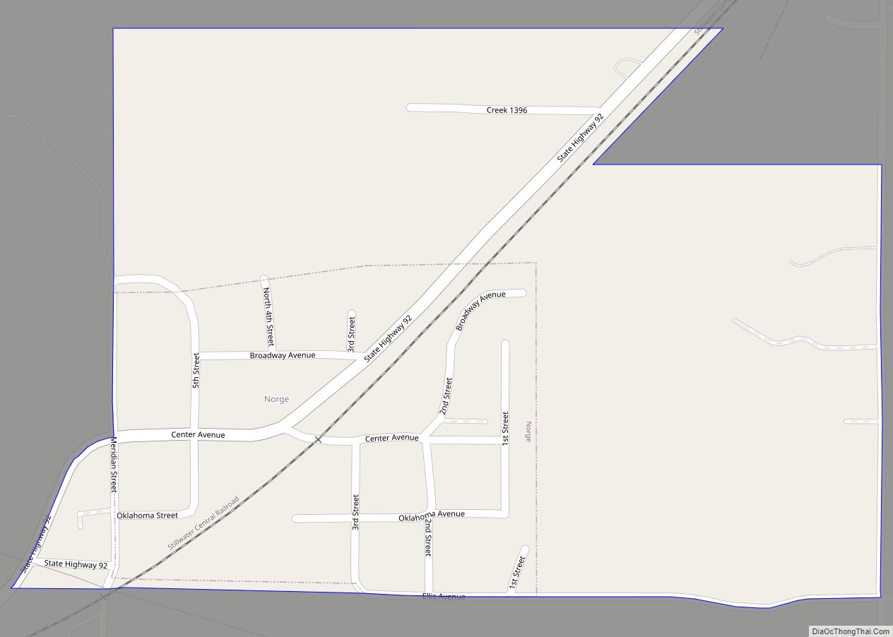
Norge is a town in Grady County, Oklahoma, United States. The population was 129 at the 2020 census, a 11% decrease from 2010. Norge town overview: Name: Norge town LSAD Code: 43 LSAD Description: town (suffix) State: Oklahoma County: Grady County Elevation: 1,270 ft (387 m) Total Area: 0.32 sq mi (0.83 km²) Land Area: 0.32 sq mi (0.83 km²) Water Area: 0.00 sq mi … Read more

Map of Noble city, Oklahoma

Map of Noble city, Oklahoma

Noble is a city in Cleveland County, Oklahoma, United States, and is part of the Oklahoma City Metropolitan Area. The population was 6,985 at the 2020 census, a 7.8% increase from 2010. Noble is Cleveland County’s third-largest city behind Norman and Moore. Noble city overview: Name: Noble city LSAD Code: 25 LSAD Description: city (suffix) … Read more

Map of Ninnekah town

Map of Ninnekah town

Ninnekah is a town in Grady County, Oklahoma, United States. The population was 775 at the 2020 census, a 22.7% decrease from 2010. Ninnekah town overview: Name: Ninnekah town LSAD Code: 43 LSAD Description: town (suffix) State: Oklahoma County: Grady County Elevation: 1,112 ft (339 m) Total Area: 10.18 sq mi (26.36 km²) Land Area: 10.18 sq mi (26.36 km²) Water Area: 0.00 sq mi … Read more

Map of Nicut CDP

Map of Nicut CDP

Nicut is an unincorporated community and census-designated place in Sequoyah County, Oklahoma, United States. Its population was 360 as of the 2010 census. Nicut CDP overview: Name: Nicut CDP LSAD Code: 57 LSAD Description: CDP (suffix) State: Oklahoma County: Sequoyah County Elevation: 581 ft (177 m) Total Area: 16.32 sq mi (42.27 km²) Land Area: 16.19 sq mi (41.94 km²) Water Area: 0.13 sq mi … Read more

Map of Nicoma Park city

Map of Nicoma Park city

Nicoma Park is a city in Oklahoma County, Oklahoma, United States, and a part of the Oklahoma City metropolitan area. The name Nicoma is a portmanteau of the first three letters of Nichols, for G.A. Nichols, and the last three letters of Oklahoma. The population was 2,313 at the 2020 census, a 3.3% decrease from … Read more

Map of Nichols Hills city

Map of Nichols Hills city

Nichols Hills is a city in Oklahoma County, Oklahoma, United States, and a part of the Oklahoma City metropolitan area. The population was 3,870 as of the 2020 census, a 4.3% increase from 2010. Nichols Hills city overview: Name: Nichols Hills city LSAD Code: 25 LSAD Description: city (suffix) State: Oklahoma County: Oklahoma County Elevation: … Read more

Map of Ochelata town

Map of Ochelata town

Ochelata /oʊʃəˈleɪtə/ is a town in Washington County, Oklahoma, United States. The population was 424 at the 2010 census, a decline of 14.2 percent from the figure of 494 recorded in 2000. Ochelata town overview: Name: Ochelata town LSAD Code: 43 LSAD Description: town (suffix) State: Oklahoma County: Washington County Elevation: 738 ft (225 m) Total Area: … Read more

Map of Oakwood town, Oklahoma

Map of Oakwood town, Oklahoma

Oakwood is a town in Dewey County, Oklahoma, United States. The population was 65 at the 2010 census. Oakwood town overview: Name: Oakwood town LSAD Code: 43 LSAD Description: town (suffix) State: Oklahoma County: Dewey County Elevation: 1,834 ft (559 m) Total Area: 0.24 sq mi (0.61 km²) Land Area: 0.24 sq mi (0.61 km²) Water Area: 0.00 sq mi (0.00 km²) Total Population: 74 Population … Read more

Map of Oaks town, Oklahoma

Map of Oaks town, Oklahoma

Oaks is a town in Cherokee and Delaware counties in the U.S. state of Oklahoma. The population was 288 at the 2010 census, a decrease from the figure of 412 recorded in 2000. Oaks town overview: Name: Oaks town LSAD Code: 43 LSAD Description: town (suffix) State: Oklahoma County: Cherokee County, Delaware County Elevation: 1,030 ft … Read more

Map of Oakland town, Oklahoma

Map of Oakland town, Oklahoma

Oakland is a town in Marshall County, Oklahoma, United States. The population was 674 at the 2000 census and grew to a population of 1,057 as of the 2010 census, an increase of 56.8%. Oakland town overview: Name: Oakland town LSAD Code: 43 LSAD Description: town (suffix) State: Oklahoma County: Marshall County Elevation: 810 ft (247 m) … Read more