Map of Big Cabin town

Map of Big Cabin town

Big Cabin is a town in Craig County, Oklahoma, United States. The population was 265 at the 2010 census, a decrease of 9.6 percent from the figure of 293 recorded in 2000. Big Cabin town overview: Name: Big Cabin town LSAD Code: 43 LSAD Description: town (suffix) State: Oklahoma County: Craig County Elevation: 722 ft (220 m) … Read more

Map of Bethel Acres town

Map of Bethel Acres town

Bethel Acres is a town in Pottawatomie County, Oklahoma. The population was 2,895 at the time of the 2010 census, an increase of 5.9 percent from the figure of 2,735 in 2000. It is primarily a bedroom community for people who work in the three nearby larger cities of Shawnee, Tecumseh and Oklahoma City. Bethel … Read more

Map of Bethany city, Oklahoma

Map of Bethany city, Oklahoma

Bethany is a city in Oklahoma County, Oklahoma, United States, and a part of the Oklahoma City metropolitan area. Bethany has a population of 20,831 at the 2020 census, a 9.3% increase from 2010. The community was founded in 1909 by followers of the Church of the Nazarene from Oklahoma City. Bethany city overview: Name: … Read more

Map of Bessie town

Map of Bessie town

Bessie is a town in Washita County, Oklahoma, United States. The population was 181 at the 2010 census, a 4.7 percent decline from 190 in 2000. Bessie town overview: Name: Bessie town LSAD Code: 43 LSAD Description: town (suffix) State: Oklahoma County: Washita County Elevation: 1,552 ft (473 m) Total Area: 0.52 sq mi (1.34 km²) Land Area: 0.52 sq mi (1.34 km²) … Read more

Map of Bernice town, Oklahoma

Map of Bernice town, Oklahoma

Bernice is a town in Delaware County, Oklahoma, United States. The population was 562 at the 2010 census, an increase of 11.5 percent over the figure of 504 recorded in 2000. The town is now primarily a vacation and retirement area. It claims to be the “Crappie Fishing Capital of the World.” Bernice town overview: … Read more

Map of Bennington town, Oklahoma

Map of Bennington town, Oklahoma

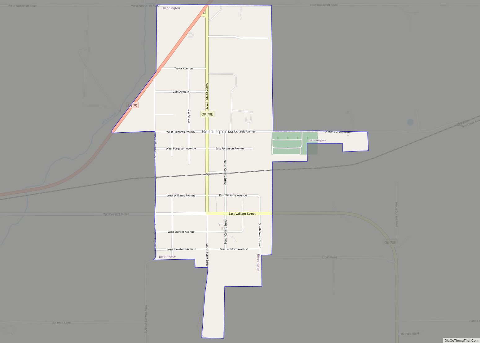
Bennington is a town in Bryan County, Oklahoma, United States. The population was 334 at the 2010 census. Bennington town overview: Name: Bennington town LSAD Code: 43 LSAD Description: town (suffix) State: Oklahoma County: Bryan County Elevation: 627 ft (191 m) Total Area: 0.73 sq mi (1.90 km²) Land Area: 0.73 sq mi (1.90 km²) Water Area: 0.00 sq mi (0.00 km²) Total Population: 282 Population … Read more

Map of Bell CDP, Oklahoma

Map of Bell CDP, Oklahoma

Bell is a census-designated place (CDP) in Adair County, Oklahoma, United States. The population was 535 at the 2010 census, an 11.1 percent decline from the figure of 602 recorded in 2000. Bell CDP overview: Name: Bell CDP LSAD Code: 57 LSAD Description: CDP (suffix) State: Oklahoma County: Adair County Total Area: 4.70 sq mi (12.18 km²) Land … Read more

Map of Belfonte CDP

Map of Belfonte CDP

Belfonte is a census-designated place (CDP) in Sequoyah County, Oklahoma, United States. It is part of the Fort Smith, Arkansas-Oklahoma Metropolitan Statistical Area. The population was 426 at the 2000 census. Belfonte CDP overview: Name: Belfonte CDP LSAD Code: 57 LSAD Description: CDP (suffix) State: Oklahoma County: Sequoyah County Total Area: 7.93 sq mi (20.55 km²) Land Area: … Read more

Map of Blackburn town, Oklahoma

Map of Blackburn town, Oklahoma

Blackburn is a town in Pawnee County, Oklahoma, United States. The population was 108 at the 2010 census, up 5.9 percent from the figure of 102 recorded in 2000. It is 12 miles (19 km) east of the city of Pawnee. Blackburn town overview: Name: Blackburn town LSAD Code: 43 LSAD Description: town (suffix) State: Oklahoma … Read more

Map of Bixby city

Map of Bixby city, Oklahoma

Bixby is a city in Tulsa and Wagoner counties in the U.S. state of Oklahoma, and is a suburb of Tulsa. The population was 28,609 at the 2020 census and 20,884 in the 2010 census, an increase of 13.70 percent In 2010, Bixby became the 19th largest city in Oklahoma. It is nicknamed “The Garden … Read more

Map of Bison CDP, Oklahoma

Map of Bison CDP, Oklahoma

Bison is an unincorporated community and census-designated place (CDP) located on US Highway 81 in Garfield County, Oklahoma, United States, consisting of a 30-acre (12 ha) town plat. As of the 2010 census, it had a population of 65. The community was named for nearby Buffalo Springs, a historic stagecoach stop and a watering hole on … Read more

Map of Bluejacket town

Map of Bluejacket town

Bluejacket is a town in eastern Craig County, Oklahoma, United States. The population was 339 at the 2010 census, an increase of 23.7 percent over the figure of 274 recorded in 2000. Bluejacket was named for its first postmaster, the Rev. Charles Blue Jacket, one-time chief of the Shawnee and grandson of noted leader Blue … Read more