Map of Welch town

Map of Welch town, Oklahoma

Welch is a town in northern Craig County, Oklahoma, United States. It is 8 miles (13 km) south of the Kansas state line, at the intersection of state highways 2 and 10 with U.S. Highway 59. The population was 619 at the 2010 census, an increase of 3.7 percent over the figure of 597 recorded in … Read more

Map of Webbers Falls town

Map of Webbers Falls town

Webbers Falls is a town in southeastern Muskogee County, Oklahoma, United States. The population was 616 at the 2010 census, a decline of 14.9 percent from the figure of 724 recorded in 2000. The name comes from a seven-foot waterfall in the Arkansas River named in honor of Walter Webber, a Cherokee chief who established … Read more

Map of Webb City town, Oklahoma

Map of Webb City town, Oklahoma

Webb City is an unincorporated town in northwestern Osage County, Oklahoma, United States. The population was 62 at the 2010 census, a 34.7 percent decline from the figure of 95 recorded in 2000. It was named for its founder, Horace Webb, on whose land the town was founded. The Webb City post office opened December … Read more

Map of Weatherford city

Map of Weatherford city, Oklahoma

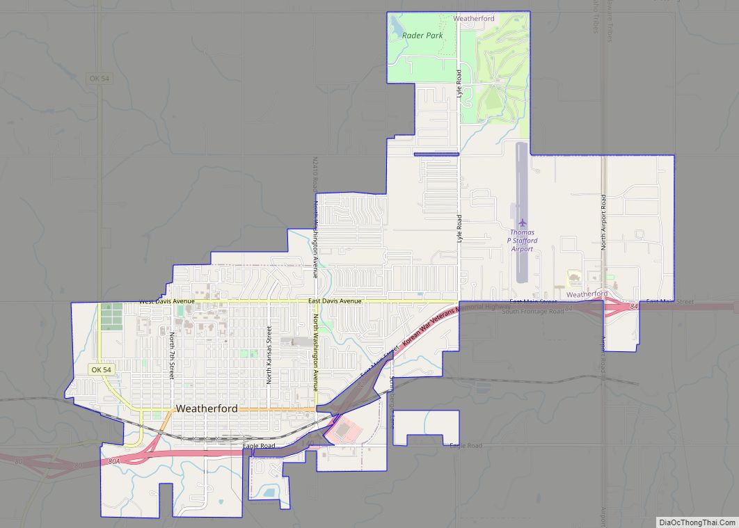
Weatherford is a city in Custer County, Oklahoma, United States. The population was 10,833 at the 2010 census. Weatherford city overview: Name: Weatherford city LSAD Code: 25 LSAD Description: city (suffix) State: Oklahoma County: Custer County Elevation: 1,634 ft (498 m) Total Area: 7.66 sq mi (19.84 km²) Land Area: 7.66 sq mi (19.83 km²) Water Area: 0.00 sq mi (0.00 km²) Total Population: 12,076 Population … Read more

Map of Waynoka city

Map of Waynoka city

Waynoka is a city in Woods County, Oklahoma, United States. It is located on U.S. Highway 281 and State Highway 14, seventy miles west of Enid. The population, which peaked at 2018 in 1950, stood at 927 according to the 2010 census. Waynoka city overview: Name: Waynoka city LSAD Code: 25 LSAD Description: city (suffix) … Read more

Map of Wayne town, Oklahoma

Map of Wayne town, Oklahoma

Wayne is a town in McClain County, Oklahoma, United States. Wayne and McClain County are part of the Oklahoma City Metropolitan Area. The population was 625 at the 2020 census, a 9.2% decrease from 2010 (at that time the population was around 688). Wayne is part of the “Heart of Oklahoma” exurban area south of … Read more

Map of Waurika city

Map of Waurika city

Waurika is the county seat of Jefferson County, Oklahoma, United States. The population was 2,064 at the 2010 census, a 4.36 percent decrease from 2,158 at the 2000 census. An article from 1985 in The Oklahoman claimed that Waurika promoted itself as “The Parakeet Capital of the World”. It gave no explanation for using this … Read more

Map of Waukomis town

Map of Waukomis town

Waukomis is a town in Garfield County, Oklahoma, United States. The population was 1,286 at the 2010 census, an increase of 2.0 percent from 1,261 in 2000. Waukomis town overview: Name: Waukomis town LSAD Code: 43 LSAD Description: town (suffix) State: Oklahoma County: Garfield County Elevation: 1,250 ft (381 m) Total Area: 2.99 sq mi (7.73 km²) Land Area: 2.97 sq mi … Read more

Map of Wauhillau CDP

Map of Wauhillau CDP

Wauhillau is a census-designated place (CDP) in Adair County, Oklahoma, United States. The population was 345 at the 2010 census. Wauhillau CDP overview: Name: Wauhillau CDP LSAD Code: 57 LSAD Description: CDP (suffix) State: Oklahoma County: Adair County Elevation: 820 ft (250 m) Total Area: 9.81 sq mi (25.41 km²) Land Area: 9.77 sq mi (25.31 km²) Water Area: 0.04 sq mi (0.10 km²) Total Population: … Read more

Map of Weleetka town

Map of Weleetka town

Weleetka is a town in Okfuskee County, Oklahoma, United States. It is approximately 10 miles (16 km) southeast of Okemah, the county seat. The name is a Creek word meaning “running water.” The population was 998 at the 2010 census, a decline of 1.6 percent from the figure of 1,014 in 2000. Weleetka town overview: Name: … Read more

Map of White Water CDP

Map of White Water CDP

White Water is a census-designated place (CDP) in Delaware County, Oklahoma, United States. The population was 80 at the 2010 census. White Water CDP overview: Name: White Water CDP LSAD Code: 57 LSAD Description: CDP (suffix) State: Oklahoma County: Delaware County Elevation: 1,025 ft (312 m) Total Area: 1.20 sq mi (3.11 km²) Land Area: 1.20 sq mi (3.11 km²) Water Area: 0.00 sq mi … Read more

Map of White Oak CDP, Oklahoma

Map of White Oak CDP, Oklahoma

White Oak is an unincorporated community and census-designated place (CDP) in Craig County, Oklahoma, United States, along State Highway 66, approximately one mile (1.6 km) west of that road’s eastern terminus with U.S. Route 60. The community had a post office from October 14, 1898 until October 31, 1957. As of the 2010 census, the White … Read more