Map of Breckenridge town, Oklahoma

Map of Breckenridge town, Oklahoma

Breckinridge is a town in Garfield County, Oklahoma, United States. The population was 245 at the 2010 census. Breckenridge town overview: Name: Breckenridge town LSAD Code: 43 LSAD Description: town (suffix) State: Oklahoma County: Garfield County Elevation: 1,198 ft (365 m) Total Area: 15.29 sq mi (39.59 km²) Land Area: 15.23 sq mi (39.45 km²) Water Area: 0.06 sq mi (0.15 km²) Total Population: 199 Population … Read more

Map of Bray town

Map of Bray town

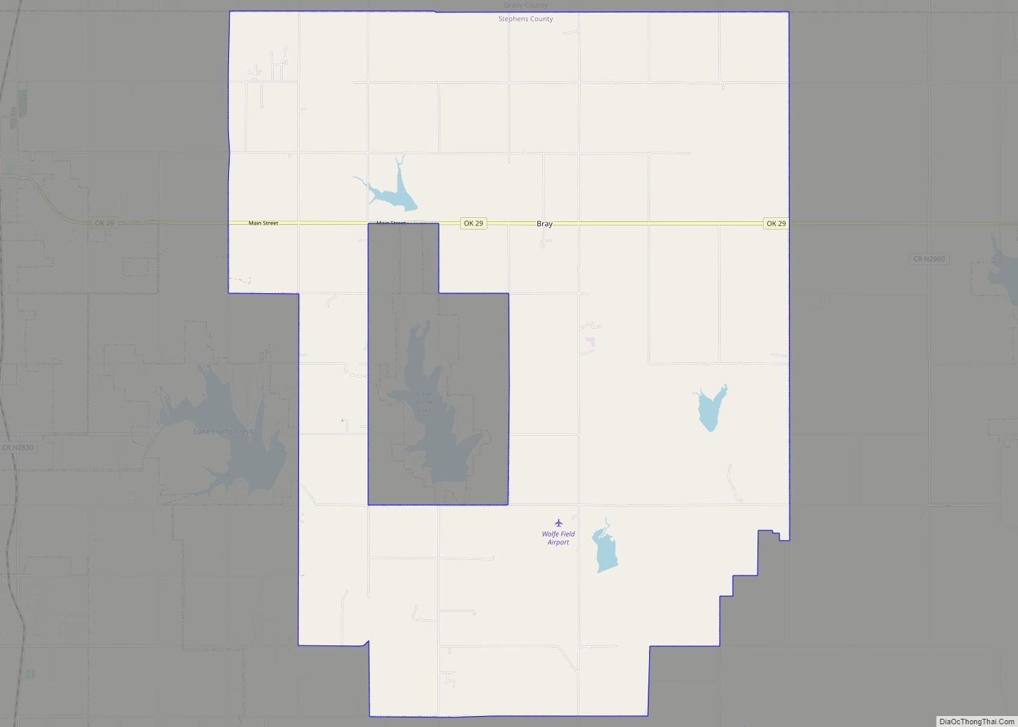
Bray is a town in Stephens County, Oklahoma, United States. The population was 1,209 at the 2010 census. Bray town overview: Name: Bray town LSAD Code: 43 LSAD Description: town (suffix) State: Oklahoma County: Stephens County Elevation: 1,260 ft (384 m) Total Area: 62.90 sq mi (162.90 km²) Land Area: 61.59 sq mi (159.51 km²) Water Area: 1.31 sq mi (3.39 km²) Total Population: 952 Population … Read more

Map of Burlington town, Oklahoma

Map of Burlington town, Oklahoma

Burlington is an agricultural center and town in northwestern Alfalfa County, Oklahoma, United States. The population was 152 at the 2010 census. Burlington town overview: Name: Burlington town LSAD Code: 43 LSAD Description: town (suffix) State: Oklahoma County: Alfalfa County Elevation: 1,217 ft (371 m) Total Area: 0.27 sq mi (0.71 km²) Land Area: 0.27 sq mi (0.71 km²) Water Area: 0.00 sq mi (0.00 km²) … Read more

Map of Burbank town, Oklahoma

Map of Burbank town, Oklahoma

Burbank is a town in western Osage County, Oklahoma, United States. The population was 141 at the 2010 census, a 9 percent decrease from the figure of 155 recorded in 2000. Burbank town overview: Name: Burbank town LSAD Code: 43 LSAD Description: town (suffix) State: Oklahoma County: Osage County Elevation: 1,030 ft (310 m) Total Area: 0.34 sq mi … Read more

Map of Bull Hollow CDP

Map of Bull Hollow CDP

Bull Hollow is an unincorporated community and census-designated place (CDP) in Delaware County, Oklahoma, United States. The population was 67 at the 2010 census. Bull Hollow CDP overview: Name: Bull Hollow CDP LSAD Code: 57 LSAD Description: CDP (suffix) State: Oklahoma County: Delaware County Elevation: 870 ft (270 m) Total Area: 5.38 sq mi (13.95 km²) Land Area: 5.38 sq mi (13.95 km²) … Read more

Map of Buffalo town, Oklahoma

Map of Buffalo town, Oklahoma

Buffalo is a town and county seat of Harper County, Oklahoma, United States. The population was 1,299 at the 2010 census. It was named after the Buffalo Creek valley, in which it is located. Buffalo town overview: Name: Buffalo town LSAD Code: 43 LSAD Description: town (suffix) State: Oklahoma County: Harper County Elevation: 1,818 ft (554 m) … Read more

Map of Brushy CDP

Map of Brushy CDP

Brushy is a census-designated place (CDP) in Sequoyah County, Oklahoma, United States, along U.S. Route 59 in the foothills of the Brushy Mountains. It is part of the Fort Smith, Arkansas-Oklahoma Metropolitan Statistical Area. The population was 900 at the 2010 census, an increase of 14.4 percent over the figure of 787 recorded in 2000. … Read more

Map of Brush Creek CDP

Map of Brush Creek CDP

Brush Creek is an unincorporated community and census-designated place (CDP) in Delaware County, Oklahoma, United States. The population was 35 at the 2010 census. Brush Creek CDP overview: Name: Brush Creek CDP LSAD Code: 57 LSAD Description: CDP (suffix) State: Oklahoma County: Delaware County Total Area: 0.82 sq mi (2.12 km²) Land Area: 0.82 sq mi (2.12 km²) Water Area: 0.00 sq mi … Read more

Map of Brooksville town, Oklahoma

Map of Brooksville town, Oklahoma

Brooksville is a town in Pottawatomie County, Oklahoma, United States. It is one of the thirteen existing all-black towns in Oklahoma. The population was 63 at the 2010 census, a 30 percent decline from the figure of 90 in 2000. Brooksville town overview: Name: Brooksville town LSAD Code: 43 LSAD Description: town (suffix) State: Oklahoma … Read more

Map of Bushyhead CDP

Map of Bushyhead CDP

Bushyhead is a census-designated place (CDP) in Rogers County, Oklahoma, United States. The population was 1,314 at the 2010 census, a 9.2 percent increase over the figure of 1,203 recorded in 2000. Established on the St. Louis-San Francisco Railway between Claremore and Vinita, the community was named for Dennis W. Bushyhead, Principal Chief of the … Read more

Map of Burns Flat town

Map of Burns Flat town

Burns Flat is a town in Washita County, Oklahoma, United States. The population was 2,057 at the 2010 census. Burns Flat town overview: Name: Burns Flat town LSAD Code: 43 LSAD Description: town (suffix) State: Oklahoma County: Washita County Incorporated: 1955 Elevation: 1,896 ft (578 m) Total Area: 0.87 sq mi (2.24 km²) Land Area: 0.87 sq mi (2.24 km²) Water Area: 0.00 sq mi … Read more

Map of Burneyville CDP

Map of Burneyville CDP

Burneyville CDP overview: Name: Burneyville CDP LSAD Code: 57 LSAD Description: CDP (suffix) State: Oklahoma FIPS code: 4010150 Online Interactive Map Burneyville online map. Source: Basemap layers from Google Map, Open Street Map (OSM), Arcgisonline, Wmflabs. Boundary Data from Database of Global Administrative Areas. Burneyville location map. Where is Burneyville CDP? Burneyville Road Map Burneyville … Read more