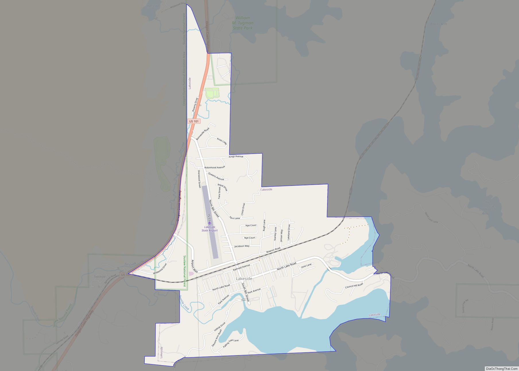
Map of Lacomb CDP
Lacomb is a census-designated place and unincorporated community in Linn County, Oregon, United States, located about 10 miles (16 km) northeast of Lebanon. It was named in December 1889 by W.J. Turnidge, a son of a pioneer. As of the 2019 Census it had a population of 481. Lacomb CDP overview: Name: Lacomb CDP LSAD Code: ... Read more
Map of Lacomb CDP
Map of Labish Village CDP
Labish Village is a census-designated place (CDP) in Marion County, Oregon, United States. The population was 454 at the 2020 census. It is part of the Salem Metropolitan Statistical Area. Labish Village CDP overview: Name: Labish Village CDP LSAD Code: 57 LSAD Description: CDP (suffix) State: Oregon County: Marion County Elevation: 154 ft (47 m) Total Area: ... Read more
Map of Labish Village CDP
Map of La Pine city
La Pine is a city in Deschutes County, Oregon, United States, incorporated on December 7, 2006. La Pine is part of the Bend, Oregon Metropolitan Statistical Area. The population was 2,512 people as of the 2020 Census. La Pine is in an isolated area of Central Oregon, consisting of a loose collection of homes and ... Read more
Map of La Pine city
Map of La Grande city, Oregon
La Grande /ləˈɡrænd/ is a city in Union County, Oregon, United States. La Grande is Union County’s largest city, with a population of 13,082 at the time of the 2010 U.S. Census. The La Grande metro population is 25,076. It is the 16th largest metropolitan area in Oregon. La Grande is located within the Grande ... Read more
Map of La Grande city, Oregon
Map of Lookingglass CDP
Lookingglass is an unincorporated community and census-designated place in the Lookingglass Valley of Douglas County, Oregon, United States, about 9 miles (14 km) southwest of Roseburg. As of the 2010 census it had a population of 855. Lookingglass is considered a suburb of Roseburg. Lookingglass CDP overview: Name: Lookingglass CDP LSAD Code: 57 LSAD Description: CDP ... Read more
Map of Lookingglass CDP
Map of Long Creek city, Oregon
Long Creek is a city in Grant County, Oregon, United States. The population was 173 at the 2020 census. The city is named after John Long, a prominent miner who came to Grant County in 1862 during the Canyon City rush of that same year. Located in a high valley of the Blue Mountains, ranching ... Read more
Map of Long Creek city, Oregon
Map of Lonerock city
Lonerock is a city in Gilliam County, Oregon, United States, twenty miles east of Condon. The population was 21 at the 2010 census. Lonerock city overview: Name: Lonerock city LSAD Code: 25 LSAD Description: city (suffix) State: Oregon County: Gilliam County Incorporated: 1901 Elevation: 2,800 ft (900 m) Total Area: 1.01 sq mi (2.62 km²) Land Area: 1.01 sq mi (2.62 km²) Water ... Read more
Map of Lonerock city
Map of Lincoln City
Lincoln City is a city in Lincoln County on the Oregon Coast of the United States, between Tillamook and Newport. It is named after the county, which was named in honor of former U.S. President Abraham Lincoln. The population was 9,815 at the 2020 Census. Lincoln City city overview: Name: Lincoln City city LSAD Code: ... Read more
Map of Lincoln City
Map of Lincoln Beach CDP
Lincoln Beach is a census-designated place (CDP) in Lincoln County, Oregon, United States. It includes the unincorporated communities of Lincoln Beach and Gleneden Beach. The total population was 2,045 at the 2010 census. Lincoln Beach CDP overview: Name: Lincoln Beach CDP LSAD Code: 57 LSAD Description: CDP (suffix) State: Oregon County: Lincoln County Elevation: 46 ft ... Read more
Map of Lincoln Beach CDP
Map of Lexington town, Oregon
Lexington is a city in Morrow County, Oregon, United States. The population was 238 at the 2010 census. It is part of the Pendleton–Hermiston Micropolitan Statistical Area. Lexington town overview: Name: Lexington town LSAD Code: 43 LSAD Description: town (suffix) State: Oregon County: Morrow County Incorporated: 1903 Elevation: 1,450 ft (440 m) Total Area: 0.44 sq mi (1.13 km²) Land ... Read more
Map of Lexington town, Oregon
Map of Lebanon city, Oregon
Lebanon (/ˈlɛbənən/ LEB-ən-ən) is a city in Linn County, Oregon, United States. Lebanon is located in northwest Oregon, southeast of Salem. The population was 19,690 at the 2020 census. Lebanon sits beside the South Santiam River on the eastern edge of the Willamette Valley, close to the Cascade Range and a 25-minute drive to either ... Read more
Map of Lebanon city, Oregon
Map of Langlois CDP
Langlois /ˈlæŋlɪs/ is an unincorporated community and census-designated place in Curry County, Oregon, United States, on the Oregon Coast established in 1881. It had a population of 177 in 2010. Langlois was once famous for its blue cheese, until the cheese factory burned down in the 1950s. It was never rebuilt. Langlois was named for ... Read more
Map of Langlois CDP