Map of Redmond city

Map of Redmond city, Oregon

Redmond is a city in Deschutes County, Oregon, United States. Incorporated on July 6, 1910, the city is on the eastern side of Oregon’s Cascade Range, in the High Desert in Central Oregon. From Redmond there is access to recreational opportunities. Redmond is a full-service municipality and one of the fastest-growing industrial and residential communities … Read more

Map of Raleigh Hills CDP

Map of Raleigh Hills CDP

Raleigh Hills is a census-designated place and neighborhood in Washington County, Oregon within the metropolitan area of Portland, Oregon, United States. It is located in the southwest hills in Washington County, with Beaverton to the west, West Slope to the north, and Progress and Garden Home to the south. As of the 2000 census, the … Read more

Map of Rainier city

Map of Rainier city, Oregon

Rainier (/reɪˈnɪər/ ray-NEER) is a city in Columbia County, Oregon, United States. The city’s population was 1,895 at the 2010 census. Rainier is on the south bank of the Columbia River across from Kelso and Longview, Washington. Rainier city overview: Name: Rainier city LSAD Code: 25 LSAD Description: city (suffix) State: Oregon County: Columbia County … Read more

Map of Prospect CDP, Oregon

Map of Prospect CDP, Oregon

Prospect is an unincorporated community and census-designated place (CDP) in Jackson County, in the U.S. state of Oregon. It lies along Oregon Route 62 on the Rogue River, in the Rogue River – Siskiyou National Forest. As of the 2010 census it had a population of 455. Prospect CDP overview: Name: Prospect CDP LSAD Code: … Read more

Map of Pronghorn CDP

Map of Pronghorn CDP

Pronghorn is a census-designated place (CDP) and resort community in Deschutes County, Oregon, United States. It is part of the Bend, Oregon Metropolitan Statistical Area. The residential population was 34 at the 2010 census. It comprises the Pronghorn Golf Club, located 4 miles (6 km) south of Redmond. Pronghorn CDP overview: Name: Pronghorn CDP LSAD Code: … Read more

Map of Prineville city

Map of Prineville city

Prineville is a city in and the seat of Crook County, Oregon, United States. It was named for the first merchant located in the present location, Barney Prine. The population was 9,253 at the 2010 census. Prineville city overview: Name: Prineville city LSAD Code: 25 LSAD Description: city (suffix) State: Oregon County: Crook County Incorporated: … Read more

Map of Prescott city, Oregon

Map of Prescott city, Oregon

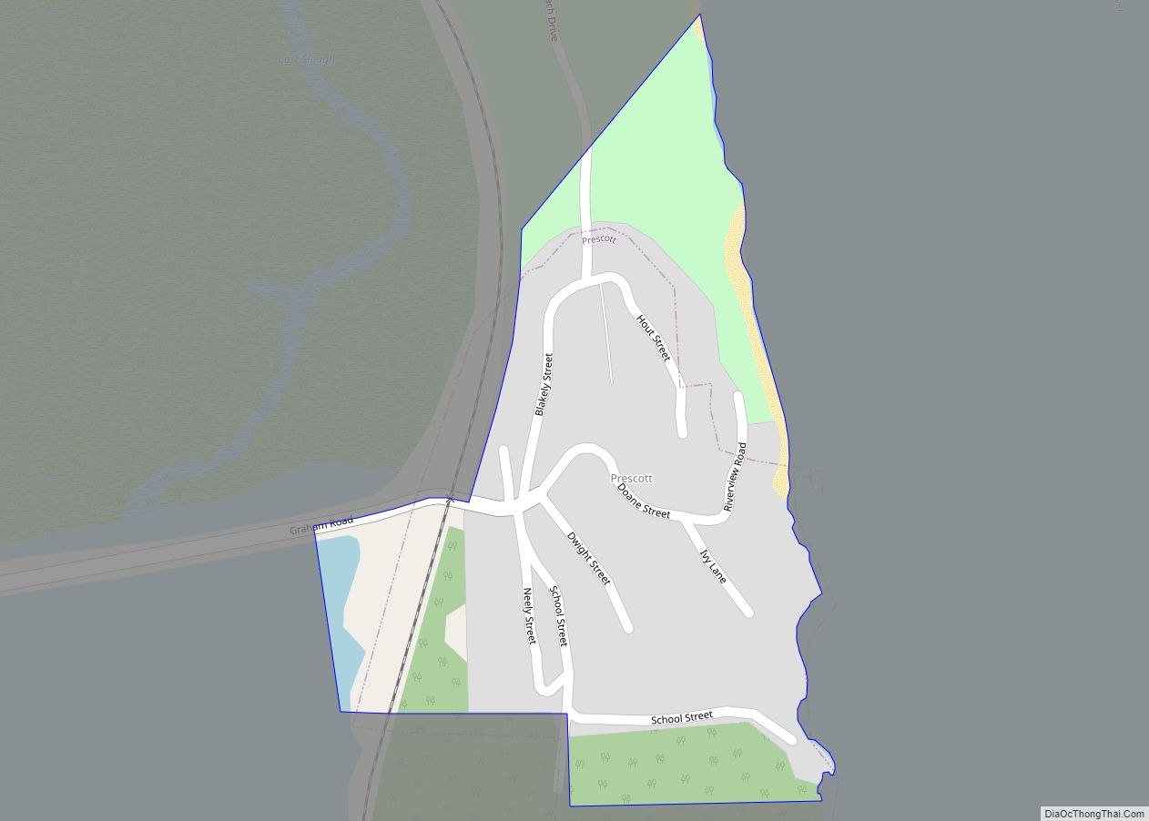
Prescott is a city in Columbia County, Oregon, United States. It was named in 1905 for the owner of the local sawmill. The population was 68 in 2021, with the median age of 60 years and a split of 53% female with 47% male. Prescott city overview: Name: Prescott city LSAD Code: 25 LSAD Description: … Read more

Map of Prairie City, Oregon

Map of Prairie City, Oregon

Prairie City is a city in Grant County, Oregon, United States. The population was 909 at the 2010 census. The community was incorporated by the Oregon Legislative Assembly on February 23, 1891. Prairie City overview: Name: Prairie City LSAD Code: 25 LSAD Description: city (suffix) State: Oregon County: Grant County Incorporated: 1891 Elevation: 3,535 ft (1,077 m) … Read more

Map of Powers city, Oregon

Map of Powers city, Oregon

Powers is a city in Coos County, Oregon, United States. The population was 689 at the 2010 census. Powers city overview: Name: Powers city LSAD Code: 25 LSAD Description: city (suffix) State: Oregon County: Coos County Incorporated: 1945 Elevation: 266 ft (81 m) Total Area: 0.63 sq mi (1.64 km²) Land Area: 0.58 sq mi (1.51 km²) Water Area: 0.05 sq mi (0.13 km²) Total Population: … Read more

Map of Port Orford city

Map of Port Orford city

Port Orford (Tolowa: tr’ee-ghi~’- ’an’ ) is a city in Curry County on the southern coast of Oregon, United States. The population was 1,133 at the 2010 census. The city takes its name from George Vancouver’s original name for nearby Cape Blanco, which he named for George, Earl of Orford, “a much-respected friend.” Port Orford … Read more

Map of Redwood CDP, Oregon

Map of Redwood CDP, Oregon

Redwood is a census-designated place (CDP) in Josephine County, Oregon, United States. The population was 2,627 at the 2010 census, down from 5,844 at the 2000 census as it has lost territory to the neighboring city of Grants Pass. Redwood CDP overview: Name: Redwood CDP LSAD Code: 57 LSAD Description: CDP (suffix) State: Oregon County: … Read more

Map of Rogue River city

Map of Rogue River city

Rogue River is a city in Jackson County, Oregon, United States. As of the 2020 census the population was 2,407. Rogue River city overview: Name: Rogue River city LSAD Code: 25 LSAD Description: city (suffix) State: Oregon County: Jackson County Incorporated: 1912 Elevation: 1,004 ft (306 m) Total Area: 0.96 sq mi (2.50 km²) Land Area: 0.96 sq mi (2.50 km²) Water Area: … Read more