Map of Dayville town

Map of Dayville town

Dayville is a city along U.S. Route 26 in Grant County, in the U.S. state of Oregon. It was incorporated in 1913. The population was 149 at the 2010 census. Dayville town overview: Name: Dayville town LSAD Code: 43 LSAD Description: town (suffix) State: Oregon County: Grant County Incorporated: 1913 Elevation: 2,369 ft (722 m) Total Area: … Read more

Map of Dayton city, Oregon

Map of Dayton city, Oregon

Dayton is a city in Yamhill County, Oregon, United States. The population was 2,678 at the 2020 census. Dayton city overview: Name: Dayton city LSAD Code: 25 LSAD Description: city (suffix) State: Oregon County: Yamhill County Incorporated: 1880 Elevation: 161 ft (48.7 m) Total Area: 0.84 sq mi (2.17 km²) Land Area: 0.84 sq mi (2.17 km²) Water Area: 0.00 sq mi (0.00 km²) Total Population: … Read more

Map of Days Creek CDP

Map of Days Creek CDP

Days Creek is an unincorporated community and census-designated place in Douglas County, Oregon, United States. At the 2010 census it had a population of 272. The community was named after the local creek, which in turn was named for Patrick and George Day, who settled near its mouth in 1851. The post office was established … Read more

Map of Damascus CDP, Oregon

Map of Damascus CDP, Oregon

Damascus CDP overview: Name: Damascus CDP LSAD Code: 57 LSAD Description: CDP (suffix) State: Oregon County: Clackamas County FIPS code: 4117800 Online Interactive Map Damascus online map. Source: Basemap layers from Google Map, Open Street Map (OSM), Arcgisonline, Wmflabs. Boundary Data from Database of Global Administrative Areas. Damascus location map. Where is Damascus CDP? Damascus … Read more

Map of Donald city

Map of Donald city, Oregon

Donald is a city in Marion County, Oregon, United States. The population was 1,009 at the 2020 census. It is part of the Salem Metropolitan Statistical Area. Donald city overview: Name: Donald city LSAD Code: 25 LSAD Description: city (suffix) State: Oregon County: Marion County Incorporated: 1912 Elevation: 198 ft (60.35 m) Total Area: 0.38 sq mi (0.98 km²) Land … Read more

Map of Dillard CDP, Oregon

Map of Dillard CDP, Oregon

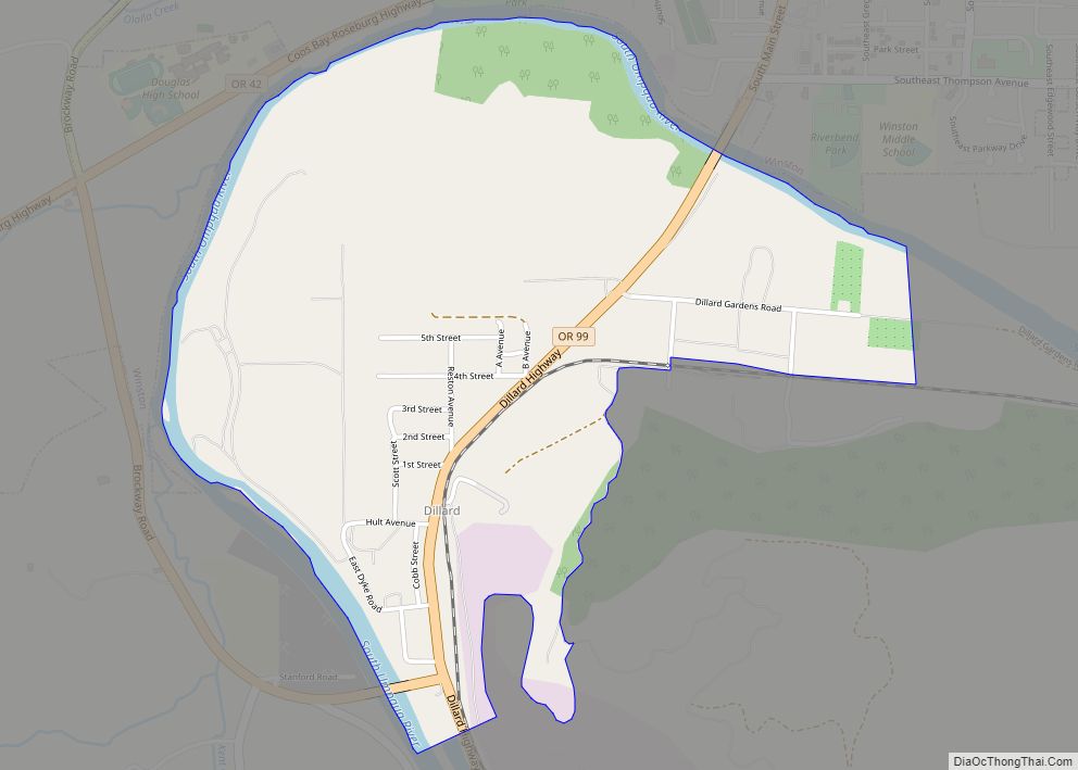
Dillard is an unincorporated community and census-designated place in Douglas County, Oregon, United States. Dillard is south of the city of Winston. Dillard has a post office with ZIP code 97432. As of the 2010 census, it had a population of 478. Dillard CDP overview: Name: Dillard CDP LSAD Code: 57 LSAD Description: CDP (suffix) … Read more

Map of Detroit city, Oregon

Map of Detroit city, Oregon

Detroit is a city in Marion County, Oregon, United States. It was named for Detroit, Michigan, in the 1890s because of the large number of people from Michigan in the community. The population was 203 at the 2020 census. It is part of the Salem Metropolitan Statistical Area. Detroit city overview: Name: Detroit city LSAD … Read more

Map of Deschutes River Woods CDP

Map of Deschutes River Woods CDP

Deschutes River Woods is a census-designated place (CDP) and unincorporated community in Deschutes County, Oregon, United States. It is part of the Bend, Oregon Metropolitan Statistical Area. The population was 5,077 at the 2010 census. Deschutes River Woods CDP overview: Name: Deschutes River Woods CDP LSAD Code: 57 LSAD Description: CDP (suffix) State: Oregon County: … Read more

Map of Depoe Bay city

Map of Depoe Bay city

Depoe Bay is a city in Lincoln County, Oregon, United States, located on U.S. Route 101 on the Pacific Ocean. The population was 1,398 at the 2010 census. The bay of the same name is a 6-acre (2.4 ha) harbor that the city promotes as the world’s smallest navigable harbor. Depoe Bay city overview: Name: Depoe … Read more

Map of Deer Island CDP

Map of Deer Island CDP

Deer Island is an unincorporated community and census-designated place in Columbia County, Oregon, United States. As of the 2010 census it had a population of 294. The community is located along U.S. Route 30 north-northwest of Columbia City. Deer Island has a post office with ZIP code 97054. Deer Island CDP overview: Name: Deer Island … Read more

Map of Elkton city, Oregon

Map of Elkton city, Oregon

Elkton is a city in Douglas County, Oregon, United States. It is located on the lower Umpqua River, at the junction of Oregon Route 38 and Oregon Route 138, about 20 miles (32 km) west of Interstate 5 and about 14 miles (23 km) west of Drain. The population was 195 at the 2010 census, an increase … Read more

Map of Elgin city, Oregon

Map of Elgin city, Oregon

Elgin is a city in Union County, Oregon, United States. The population was 1,711 at the 2010 census. The community is named after the Lady Elgin, a ship lost on Lake Michigan. The city is known for the Elgin Opera House, originally dedicated in 1912. Elgin city overview: Name: Elgin city LSAD Code: 25 LSAD … Read more