Map of Lake Park village, North Carolina
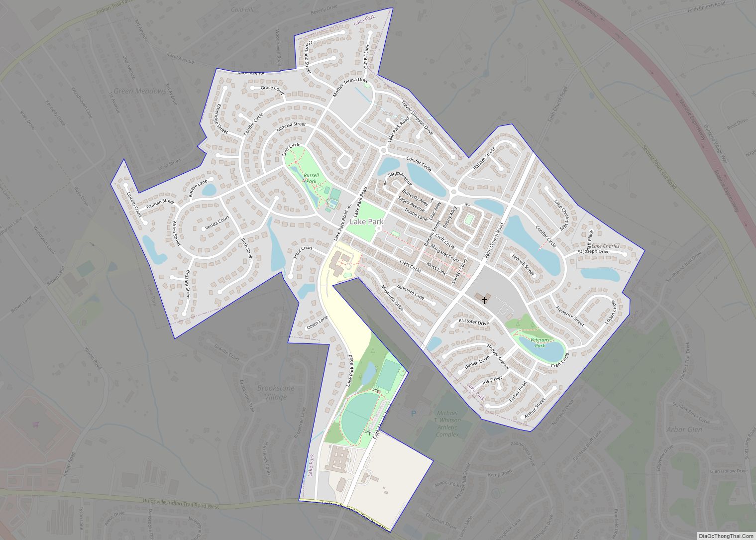
Lake Park is a village in Union County, North Carolina, United States. The population was 3,422 at the 2010 census. Lake Park village overview: Name: Lake Park village LSAD Code: 47 LSAD Description: village (suffix) State: North Carolina County: Union County Elevation: 686 ft (209 m) Total Area: 0.76 sq mi (1.97 km²) Land Area: 0.73 sq mi (1.90 km²) Water Area: 0.03 sq mi ... Read more
Map of Lake Park village, North Carolina
Map of Lake Norman of Catawba CDP
Lake Norman of Catawba CDP overview: Name: Lake Norman of Catawba CDP LSAD Code: 57 LSAD Description: CDP (suffix) State: North Carolina County: Catawba County FIPS code: 3736511 Online Interactive Map Lake Norman of Catawba online map. Source: Basemap layers from Google Map, Open Street Map (OSM), Arcgisonline, Wmflabs. Boundary Data from Database of Global ... Read more
Map of Lake Norman of Catawba CDP
Map of Lake Lure town
Lake Lure is a town in Rutherford County, North Carolina, United States. In 2020 the town population was 1,634. Lake Lure was incorporated in 1927, and acquired the lake after which it is named in 1965. Lake Lure town overview: Name: Lake Lure town LSAD Code: 43 LSAD Description: town (suffix) State: North Carolina County: ... Read more
Map of Lake Lure town
Map of Lake Junaluska CDP
Lake Junaluska CDP overview: Name: Lake Junaluska CDP LSAD Code: 57 LSAD Description: CDP (suffix) State: North Carolina County: Haywood County FIPS code: 3736480 Online Interactive Map Lake Junaluska online map. Source: Basemap layers from Google Map, Open Street Map (OSM), Arcgisonline, Wmflabs. Boundary Data from Database of Global Administrative Areas. Lake Junaluska location map. ... Read more
Map of Lake Junaluska CDP
Map of La Grange town, North Carolina
La Grange is a town in Lenoir County, North Carolina, United States. The population was 2,873 based on the 2010 census. La Grange is located in North Carolina’s Inner Banks region. La Grange town overview: Name: La Grange town LSAD Code: 43 LSAD Description: town (suffix) State: North Carolina County: Lenoir County Elevation: 108 ft (33 m) ... Read more
Map of La Grange town, North Carolina
Map of Laurinburg city
Laurinburg is a city in and the county seat of Scotland County, North Carolina, United States. Located in southern North Carolina near the South Carolina border, Laurinburg is southwest of Fayetteville and is home to St. Andrews University. The population at the 2010 Census was 15,962 people. Laurinburg city overview: Name: Laurinburg city LSAD Code: ... Read more
Map of Laurinburg city
Map of Laurel Park town, North Carolina
Laurel Park is a town in Henderson County, North Carolina, United States. The population was 2,180 at the 2010 census. It is part of the Asheville Metropolitan Statistical Area. Laurel Park town overview: Name: Laurel Park town LSAD Code: 43 LSAD Description: town (suffix) State: North Carolina County: Henderson County Incorporated: 1925 Elevation: 2,385 ft (727 m) ... Read more
Map of Laurel Park town, North Carolina
Map of Laurel Hill CDP, North Carolina
Laurel Hill CDP overview: Name: Laurel Hill CDP LSAD Code: 57 LSAD Description: CDP (suffix) State: North Carolina County: Scotland County FIPS code: 3737120 Online Interactive Map Laurel Hill online map. Source: Basemap layers from Google Map, Open Street Map (OSM), Arcgisonline, Wmflabs. Boundary Data from Database of Global Administrative Areas. Laurel Hill location map. ... Read more
Map of Laurel Hill CDP, North Carolina
Map of Lattimore town
Lattimore is a town in Cleveland County, North Carolina, United States. The population was 488 at the 2010 census. Lattimore town overview: Name: Lattimore town LSAD Code: 43 LSAD Description: town (suffix) State: North Carolina County: Cleveland County Elevation: 951 ft (290 m) Total Area: 1.02 sq mi (2.66 km²) Land Area: 1.02 sq mi (2.66 km²) Water Area: 0.00 sq mi (0.00 km²) Total Population: ... Read more
Map of Lattimore town
Map of Lasker town
Lasker is a town in Northampton County, North Carolina, United States. The population was 122 at the 2010 census. It is part of the Roanoke Rapids, North Carolina Micropolitan Statistical Area. Lasker town overview: Name: Lasker town LSAD Code: 43 LSAD Description: town (suffix) State: North Carolina County: Northampton County Elevation: 85 ft (26 m) Total Area: ... Read more
Map of Lasker town
Map of Lansing town, North Carolina
Lansing is a town in Ashe County, North Carolina, United States. The population was 126 at the 2020 census. Lansing town overview: Name: Lansing town LSAD Code: 43 LSAD Description: town (suffix) State: North Carolina County: Ashe County Elevation: 2,664 ft (812 m) Total Area: 0.38 sq mi (0.98 km²) Land Area: 0.37 sq mi (0.96 km²) Water Area: 0.01 sq mi (0.02 km²) Total Population: ... Read more
Map of Lansing town, North Carolina
Map of Landis town
Landis is a town in Rowan County, North Carolina, United States. At the 2020 census, its population was 3,109. The town is located just north of Kannapolis and south of China Grove. Landis town overview: Name: Landis town LSAD Code: 43 LSAD Description: town (suffix) State: North Carolina County: Rowan County Elevation: 899 ft (274 m) Total ... Read more
Map of Landis town