Map of Red Springs town
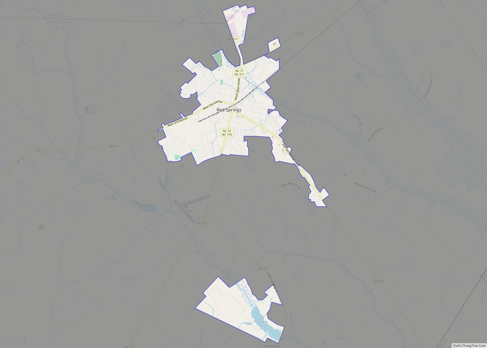
Red Springs is a town in Hoke and Robeson counties in the U.S. state of North Carolina. The population was 3,428 at the 2010 census. Red Springs town overview: Name: Red Springs town LSAD Code: 43 LSAD Description: town (suffix) State: North Carolina County: Hoke County, Robeson County Elevation: 207 ft (63 m) Total Area: 3.67 sq mi (9.50 km²) ... Read more
Map of Red Springs town
Map of Red Oak town, North Carolina
Red Oak is a town in Nash County, North Carolina, United States. It is part of the Rocky Mount, North Carolina Metropolitan Statistical Area. The population was 3,430 in 2010. Red Oak town overview: Name: Red Oak town LSAD Code: 43 LSAD Description: town (suffix) State: North Carolina County: Nash County Elevation: 203 ft (62 m) Total ... Read more
Map of Red Oak town, North Carolina
Map of Red Cross town
Red Cross is a town in Stanly County, North Carolina, United States. The population was 742 as of the 2010 Census. Red Cross town overview: Name: Red Cross town LSAD Code: 43 LSAD Description: town (suffix) State: North Carolina County: Stanly County Elevation: 659 ft (201 m) Total Area: 3.73 sq mi (9.67 km²) Land Area: 3.73 sq mi (9.67 km²) Water Area: ... Read more
Map of Red Cross town
Map of Raynham town
Raynham is a town in Robeson County, North Carolina, United States. The population was 72 at the 2010 census. Raynham town overview: Name: Raynham town LSAD Code: 43 LSAD Description: town (suffix) State: North Carolina County: Robeson County Elevation: 144 ft (44 m) Total Area: 0.12 sq mi (0.32 km²) Land Area: 0.12 sq mi (0.32 km²) Water Area: 0.00 sq mi (0.00 km²) Total Population: ... Read more
Map of Raynham town
Map of Ranlo town
Ranlo is a small town in Gaston County, North Carolina, United States and a suburb of Charlotte, located north of Gastonia. As of the 2020 census, the town population was 4,511, up from 3,434 in 2010. Ranlo town overview: Name: Ranlo town LSAD Code: 43 LSAD Description: town (suffix) State: North Carolina County: Gaston County ... Read more
Map of Ranlo town
Map of Randleman city
Randleman is a city in Randolph County, North Carolina, United States. The population was 4,113 at the 2010 census. It is the home of NASCAR’s Petty family, the Victory Junction Gang Camp and was the location of the Richard Petty Museum from 2003 to 2014. Randleman city overview: Name: Randleman city LSAD Code: 25 LSAD ... Read more
Map of Randleman city
Map of Richlands town, North Carolina
Richlands is a town in Onslow County, North Carolina, United States. The 2010 population was 1,520. It is included in the Jacksonville, North Carolina Metropolitan Statistical Area. Incorporated on March 29, 1880, it was the first town in Onslow County to have its own library and museum (home of the Onslow County Museum). Richlands was ... Read more
Map of Richlands town, North Carolina
Map of Richfield town, North Carolina
Richfield is a town in Stanly County, North Carolina, United States. The town was originally called “Ritchie’s Field,” for the prominent Ritchie family who established the post office, sawmill, and streets of the settlement. Richfield town overview: Name: Richfield town LSAD Code: 43 LSAD Description: town (suffix) State: North Carolina County: Stanly County Elevation: 643 ft ... Read more
Map of Richfield town, North Carolina
Map of Rich Square town
Rich Square is a town in Northampton County, North Carolina, United States. The population was 958 at the 2010 census. It is part of the Roanoke Rapids, North Carolina Micropolitan Statistical Area. Rich Square town overview: Name: Rich Square town LSAD Code: 43 LSAD Description: town (suffix) State: North Carolina County: Northampton County Elevation: 72 ft ... Read more
Map of Rich Square town
Map of Robersonville town
Robersonville, incorporated in 1872, is a town located in Martin County, North Carolina, United States. The population was 1,326 at the 2020 census. Robersonville is located in North Carolina’s Inner Banks region. It is home to the East Carolina Motor Speedway. Robersonville town overview: Name: Robersonville town LSAD Code: 43 LSAD Description: town (suffix) State: ... Read more
Map of Robersonville town
Map of Robbinsville town, North Carolina
Robbinsville is a town in Graham County, North Carolina, United States. The population was 597 at the 2020 census. It is the county seat of Graham County, county population 8,030. Robbinsville town overview: Name: Robbinsville town LSAD Code: 43 LSAD Description: town (suffix) State: North Carolina County: Graham County Elevation: 2,044 ft (623 m) Total Area: 0.67 sq mi ... Read more
Map of Robbinsville town, North Carolina
Map of Robbins town, North Carolina
Robbins is a city in Moore County, North Carolina, United States. The population was 1,097 at the 2010 census. Robbins town overview: Name: Robbins town LSAD Code: 43 LSAD Description: town (suffix) State: North Carolina County: Moore County Incorporated: 1935 Elevation: 440 ft (134 m) Total Area: 1.59 sq mi (4.12 km²) Land Area: 1.59 sq mi (4.12 km²) Water Area: 0.00 sq mi (0.00 km²) ... Read more
Map of Robbins town, North Carolina