Map of Vanceboro town
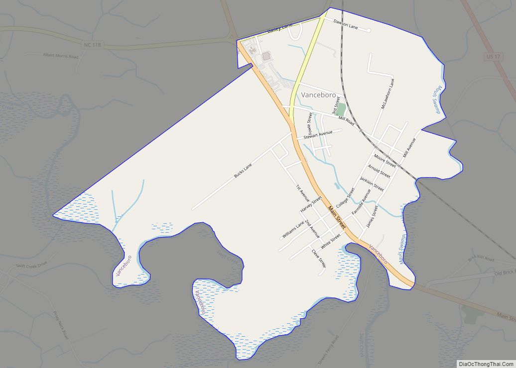
Vanceboro is a town in Craven County, North Carolina, United States. Its population was 1,005 at the 2010 Census. Originally called Swift Creek, residents renamed the town for Zebulon B. Vance after he visited there during his 1876 campaign for governor. It is part of the New Bern, North Carolina Metropolitan Statistical Area. Vanceboro town ... Read more
Map of Vanceboro town
Map of Wallburg town
Wallburg is a town in Davidson County, North Carolina, United States. It was incorporated in 2004. As of the 2020 census it had a population of 3,051. Wallburg town overview: Name: Wallburg town LSAD Code: 43 LSAD Description: town (suffix) State: North Carolina County: Davidson County Elevation: 920 ft (283 m) Total Area: 5.59 sq mi (14.48 km²) Land Area: ... Read more
Map of Wallburg town
Map of Wallace town, North Carolina
Wallace is a town in Duplin and Pender counties in the U.S. state of North Carolina. The population was 3,880 at the 2010 census. The Pender County portion of Wallace is part of the Wilmington Metropolitan Statistical Area. Wallace town overview: Name: Wallace town LSAD Code: 43 LSAD Description: town (suffix) State: North Carolina County: ... Read more
Map of Wallace town, North Carolina
Map of Walkertown town
Walkertown is a town in Forsyth County, North Carolina, United States and a rural area outside of Winston-Salem. It is part of the Piedmont Triad. The population was 5,695 at the 2020 census. Walkertown town overview: Name: Walkertown town LSAD Code: 43 LSAD Description: town (suffix) State: North Carolina County: Forsyth County Elevation: 991 ft (302 m) ... Read more
Map of Walkertown town
Map of Wakulla CDP
Wakulla is a census-designated place (CDP) in Robeson County, North Carolina, United States. During the 2010 census, the population was reported to be 105. Wakulla CDP overview: Name: Wakulla CDP LSAD Code: 57 LSAD Description: CDP (suffix) State: North Carolina County: Robeson County Elevation: 194 ft (58 m) Total Area: 0.86 sq mi (2.23 km²) Land Area: 0.86 sq mi (2.23 km²) Water ... Read more
Map of Wakulla CDP
Map of Wake Forest town
Wake Forest is a town in Franklin, Granville and Wake counties in the U.S. state of North Carolina; located almost entirely in Wake County, it lies just north of the state capital, Raleigh. At the 2020 census, the population was 47,601. That is up from 30,117 in 2010, up from 12,588 in 2000. The U.S. ... Read more
Map of Wake Forest town
Map of Wagram town
Wagram is a town in Scotland County, North Carolina, United States. The population was 840 at the 2010 Census. The town was named for the Battle of Wagram, a Napoleonic battle at Deutsch-Wagram in Austria. Wagram town overview: Name: Wagram town LSAD Code: 43 LSAD Description: town (suffix) State: North Carolina County: Scotland County Elevation: ... Read more
Map of Wagram town
Map of Wadesboro town
Wadesboro is a town and the county seat of Anson County, North Carolina, United States. The population was 5,049 at the 2020 census. The town was originally found in 1783 as New Town but changed by the North Carolina General Assembly to Wadesboro in 1787 to honor Colonel Thomas Wade, a native son, state legislator, ... Read more
Map of Wadesboro town
Map of Wade town, North Carolina
Wade is a town in Cumberland County, North Carolina, United States. The population was 556 at the 2010 census. Wade town overview: Name: Wade town LSAD Code: 43 LSAD Description: town (suffix) State: North Carolina County: Cumberland County Elevation: 138 ft (42 m) Total Area: 1.75 sq mi (4.54 km²) Land Area: 1.74 sq mi (4.51 km²) Water Area: 0.01 sq mi (0.02 km²) Total Population: ... Read more
Map of Wade town, North Carolina
Map of Waco town, North Carolina
Waco is a town in Cleveland County, North Carolina, United States. The population was 321 at the 2010 census. Waco town overview: Name: Waco town LSAD Code: 43 LSAD Description: town (suffix) State: North Carolina County: Cleveland County Elevation: 925 ft (282 m) Total Area: 0.84 sq mi (2.18 km²) Land Area: 0.84 sq mi (2.17 km²) Water Area: 0.01 sq mi (0.01 km²) Total Population: ... Read more
Map of Waco town, North Carolina
Map of Vass town
Vass is a town in Moore County, North Carolina, United States. The population was 720 at the 2010 census. Vass grew up along the railroad in the late 19th century. It was originally named Bynum and later Winder before being established as Vass in 1892. The town was incorporated in 1907. Vass town overview: Name: ... Read more
Map of Vass town
Map of Walnut Cove town
Walnut Cove is a town in Stokes County, North Carolina, United States. The population was 1,536 at the 2020 census. It is the home of Family Pharmacy and the Walnut Cove Springfest, which draws many visitors to the area. Festival-organizers marked 1889, the town’s incorporation date, but the town’s roots date to the mid-18th century ... Read more
Map of Walnut Cove town