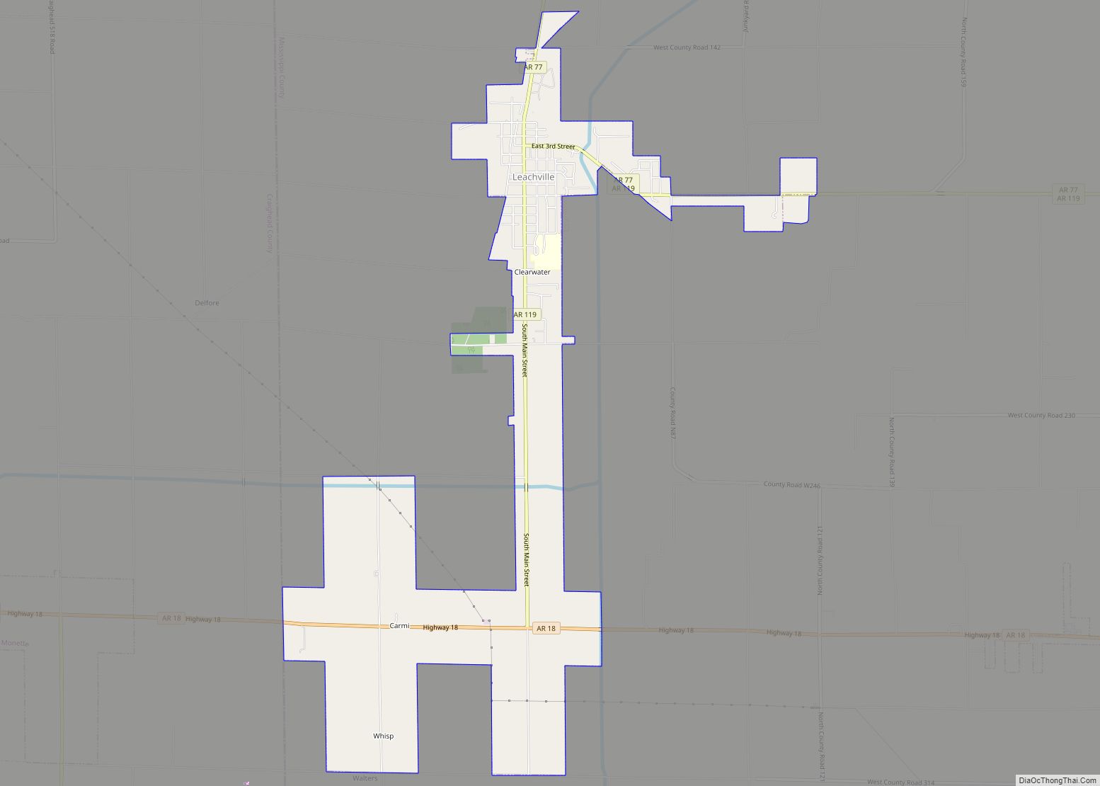
Map of Lavaca city
Lavaca (/ləˈvɑːkə/ (listen)) is a city in Sebastian County, Arkansas, United States. It is part of the Fort Smith, Arkansas–Oklahoma Metropolitan Statistical Area. As of the 2010 Census the population was 2,289. Lavaca was incorporated in 1919. Lavaca city overview: Name: Lavaca city LSAD Code: 25 LSAD Description: city (suffix) State: Arkansas County: Sebastian County ... Read more
Map of Lavaca city
Map of Landmark CDP
Landmark (formerly known as Parkers-Iron Springs) is a census-designated place (CDP) in Pulaski County, Arkansas, United States. Per the 2020 census, the population was 3,585. It is part of the Little Rock–North Little Rock–Conway Metropolitan Statistical Area. Landmark CDP overview: Name: Landmark CDP LSAD Code: 57 LSAD Description: CDP (suffix) State: Arkansas County: Pulaski County ... Read more
Map of Landmark CDP
Map of Leola town, Arkansas
Leola is a town in Grant County, Arkansas, United States. The population was 501 at the 2010 census. It is the southernmost municipality within the Central Arkansas region. Leola town overview: Name: Leola town LSAD Code: 43 LSAD Description: town (suffix) State: Arkansas County: Grant County Elevation: 269 ft (82 m) Total Area: 0.85 sq mi (2.21 km²) Land Area: ... Read more
Map of Leola town, Arkansas
Map of Lead Hill town
Lead Hill is a town in Boone County, Arkansas, United States. The population was 271 at the 2010 census. It is part of the Harrison Micropolitan Statistical Area. Lead Hill town overview: Name: Lead Hill town LSAD Code: 43 LSAD Description: town (suffix) State: Arkansas County: Boone County Elevation: 853 ft (260 m) Total Area: 0.66 sq mi (1.72 km²) ... Read more
Map of Lead Hill town
Map of Lepanto city
Lepanto is a city in Poinsett County, Arkansas, United States. The population was 1,893 at the 2010 census. It is included in the Jonesboro, Arkansas Metropolitan Statistical Area. Lepanto was named for the Greek seaport of Lepanto, site of a great crusade sea battle in 1571. Lepanto was a site for the filming of the ... Read more
Map of Lepanto city
Map of Lewisville city, Arkansas
Lewisville is a city in Lafayette County, Arkansas, United States. The population was 1,280 at the 2010 census. It is the county seat of Lafayette County. Lewisville city overview: Name: Lewisville city LSAD Code: 25 LSAD Description: city (suffix) State: Arkansas County: Lafayette County Elevation: 292 ft (89 m) Total Area: 2.18 sq mi (5.65 km²) Land Area: 2.15 sq mi (5.56 km²) ... Read more
Map of Lewisville city, Arkansas
Map of Letona town
Letona is a town in White County, Arkansas, United States. Sherrel Bennett is the current mayor. The population was 201 at the 2000 census. Letona town overview: Name: Letona town LSAD Code: 43 LSAD Description: town (suffix) State: Arkansas County: White County Elevation: 285 ft (87 m) Total Area: 0.39 sq mi (1.01 km²) Land Area: 0.39 sq mi (1.01 km²) Water Area: ... Read more
Map of Letona town
Map of Leslie city, Arkansas
Leslie is a city in Searcy County, Arkansas, United States. Located within the Boston Mountains, the most rugged subset of The Ozarks, the city was founded as a railroad and lumber town. Renamed from the original Wiley’s Cove in 1887, the city saw prosperity relating to these industries through the 1920s. Today, this history is ... Read more
Map of Leslie city, Arkansas
Map of Little Flock city
Little Flock is a city in Benton County, Arkansas, United States. The population was 3,055 at the 2020 census. It is part of the Northwest Arkansas region. Little Flock city overview: Name: Little Flock city LSAD Code: 25 LSAD Description: city (suffix) State: Arkansas County: Benton County Elevation: 1,197 ft (365 m) Total Area: 7.51 sq mi (19.46 km²) Land ... Read more
Map of Little Flock city
Map of Lincoln city, Arkansas
Lincoln is a city in Washington County, Arkansas, United States. The population was 2,294 at the 2020 census. It is part of the Northwest Arkansas metro area. Lincoln city overview: Name: Lincoln city LSAD Code: 25 LSAD Description: city (suffix) State: Arkansas County: Washington County Elevation: 1,453 ft (443 m) Land Area: 2.87 sq mi (7.42 km²) Water Area: 0.03 sq mi ... Read more
Map of Lincoln city, Arkansas
Map of Lexa town
Lexa is a town in northern Phillips County, Arkansas, United States. The population was 286 at the 2010 census. Lexa town overview: Name: Lexa town LSAD Code: 43 LSAD Description: town (suffix) State: Arkansas County: Phillips County Elevation: 213 ft (65 m) Total Area: 0.41 sq mi (1.06 km²) Land Area: 0.41 sq mi (1.06 km²) Water Area: 0.00 sq mi (0.00 km²) Total Population: 207 ... Read more
Map of Lexa town
Map of Lonoke city
Lonoke (/ˈloʊnoʊk/) is the second most populous city in Lonoke County, Arkansas, United States, and serves as its county seat. According to 2010 United States Census, the population of the city is 4,245. It is part of the Little Rock–North Little Rock–Conway Metropolitan Statistical Area. Lonoke city overview: Name: Lonoke city LSAD Code: 25 LSAD ... Read more
Map of Lonoke city