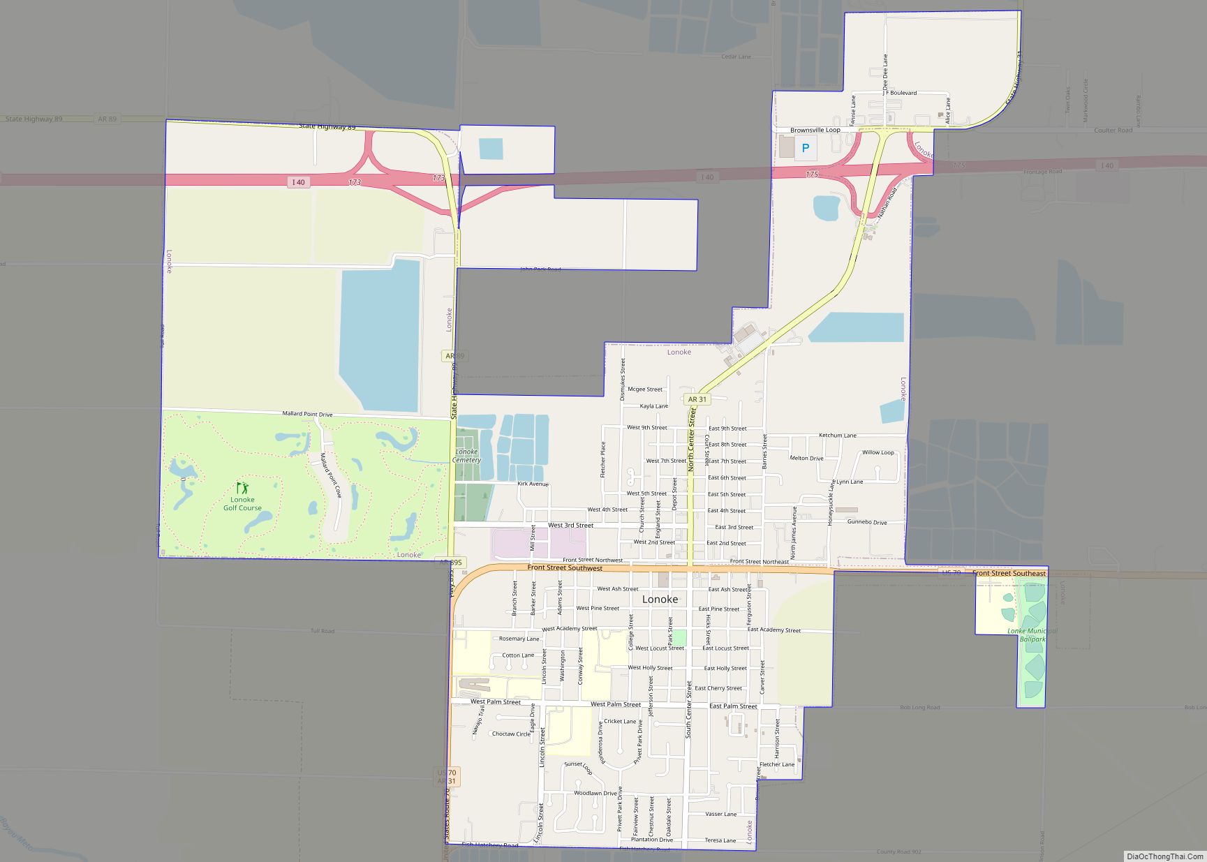
Map of London city, Arkansas
London is a city in Pope County, Arkansas, United States. The population was 1,039 at the 2010 census. It is part of the Russellville Micropolitan Statistical Area. London city overview: Name: London city LSAD Code: 25 LSAD Description: city (suffix) State: Arkansas County: Pope County Elevation: 377 ft (115 m) Total Area: 3.18 sq mi (8.24 km²) Land Area: 3.17 sq mi ... Read more
Map of London city, Arkansas
Map of Lockesburg city
Lockesburg is a city in Sevier County, Arkansas, United States. The population was 739 at the 2010 census. Lockesburg city overview: Name: Lockesburg city LSAD Code: 25 LSAD Description: city (suffix) State: Arkansas County: Sevier County Elevation: 400 ft (100 m) Total Area: 3.49 sq mi (9.03 km²) Land Area: 3.48 sq mi (9.02 km²) Water Area: 0.00 sq mi (0.01 km²) Total Population: 594 Population ... Read more
Map of Lockesburg city
Map of Louann town
Louann is a town in Ouachita County, Arkansas, United States. The population was 195 at the 2000 census, which fell to 164 in the 2010 census. It is part of the Camden Micropolitan Statistical Area. Louann town overview: Name: Louann town LSAD Code: 43 LSAD Description: town (suffix) State: Arkansas County: Ouachita County Elevation: 135 ft ... Read more
Map of Louann town
Map of Lost Bridge Village CDP
Lost Bridge Village is a census-designated place in Benton County, Arkansas, United States. Per the 2020 census, the population was 397. It is located in the Northwest Arkansas region. Lost Bridge Village CDP overview: Name: Lost Bridge Village CDP LSAD Code: 57 LSAD Description: CDP (suffix) State: Arkansas County: Benton County Elevation: 1,230 ft (370 m) Total ... Read more
Map of Lost Bridge Village CDP
Map of Lonsdale town, Arkansas
Lonsdale is a town in Garland County, Arkansas, United States. It is part of the Hot Springs Metropolitan Statistical Area. The population was 94 at the 2010 census, down from 118 in 2000. Lonsdale town overview: Name: Lonsdale town LSAD Code: 43 LSAD Description: town (suffix) State: Arkansas County: Garland County Elevation: 427 ft (130 m) Total ... Read more
Map of Lonsdale town, Arkansas
Map of Lynn town, Arkansas
Lynn is a town in Lawrence County, Arkansas, United States. The population was 288 at the 2010 census. Lynn town overview: Name: Lynn town LSAD Code: 43 LSAD Description: town (suffix) State: Arkansas County: Lawrence County Elevation: 358 ft (109 m) Total Area: 2.31 sq mi (5.99 km²) Land Area: 2.31 sq mi (5.99 km²) Water Area: 0.00 sq mi (0.00 km²) Total Population: 258 Population ... Read more
Map of Lynn town, Arkansas
Map of Luxora city
Luxora is a city in Mississippi County, Arkansas, United States. The population was 942 at the 2020 census, down from 1,178 in 2010. Luxora city overview: Name: Luxora city LSAD Code: 25 LSAD Description: city (suffix) State: Arkansas County: Mississippi County Elevation: 246 ft (75 m) Total Area: 0.85 sq mi (2.20 km²) Land Area: 0.85 sq mi (2.20 km²) Water Area: 0.00 sq mi ... Read more
Map of Luxora city
Map of Lowell city, Arkansas
Lowell is a city in Benton County, Arkansas, United States. Located within the Ozarks, first settlement was along Old Wire Road in the 1840s, and although destroyed during the Civil War, the community was reestablished by J. R. McClure and thrived when the St. Louis–San Francisco Railway came through the area in the 1880s. Today, ... Read more
Map of Lowell city, Arkansas
Map of Magazine city
Magazine is a city in Logan County, Arkansas, United States. The population was 847 at the 2010 census. The city is named for nearby Mount Magazine. 2010 State Football Champions. Magazine city overview: Name: Magazine city LSAD Code: 25 LSAD Description: city (suffix) State: Arkansas County: Logan County Elevation: 486 ft (148 m) Total Area: 1.82 sq mi (4.72 km²) ... Read more
Map of Magazine city
Map of Madison city, Arkansas
Madison is a city in St. Francis County, Arkansas, United States. The population was 769 at the 2010 census, down from 987 in 2000. Madison city overview: Name: Madison city LSAD Code: 25 LSAD Description: city (suffix) State: Arkansas County: St. Francis County Elevation: 210 ft (64 m) Total Area: 2.55 sq mi (6.61 km²) Land Area: 2.48 sq mi (6.43 km²) Water ... Read more
Map of Madison city, Arkansas
Map of Magness town
Magness is a town in Independence County, Arkansas, United States. The population was 202 at the 2010 census. The mayor is Jerrit Pectol. Magness town overview: Name: Magness town LSAD Code: 43 LSAD Description: town (suffix) State: Arkansas County: Independence County Elevation: 266 ft (81 m) Total Area: 0.61 sq mi (1.59 km²) Land Area: 0.61 sq mi (1.59 km²) Water Area: 0.00 sq mi ... Read more
Map of Magness town
Map of Malvern city, Arkansas
Malvern is a city in and the county seat of Hot Spring County, Arkansas, United States. Founded as a railroad stop at the eastern edge of the Ouachita Mountains, the community’s history and economy have been tied to available agricultural and mineral resources. The production of bricks from locally available clay has earned the city ... Read more
Map of Malvern city, Arkansas