Map of Harrison village, Nebraska
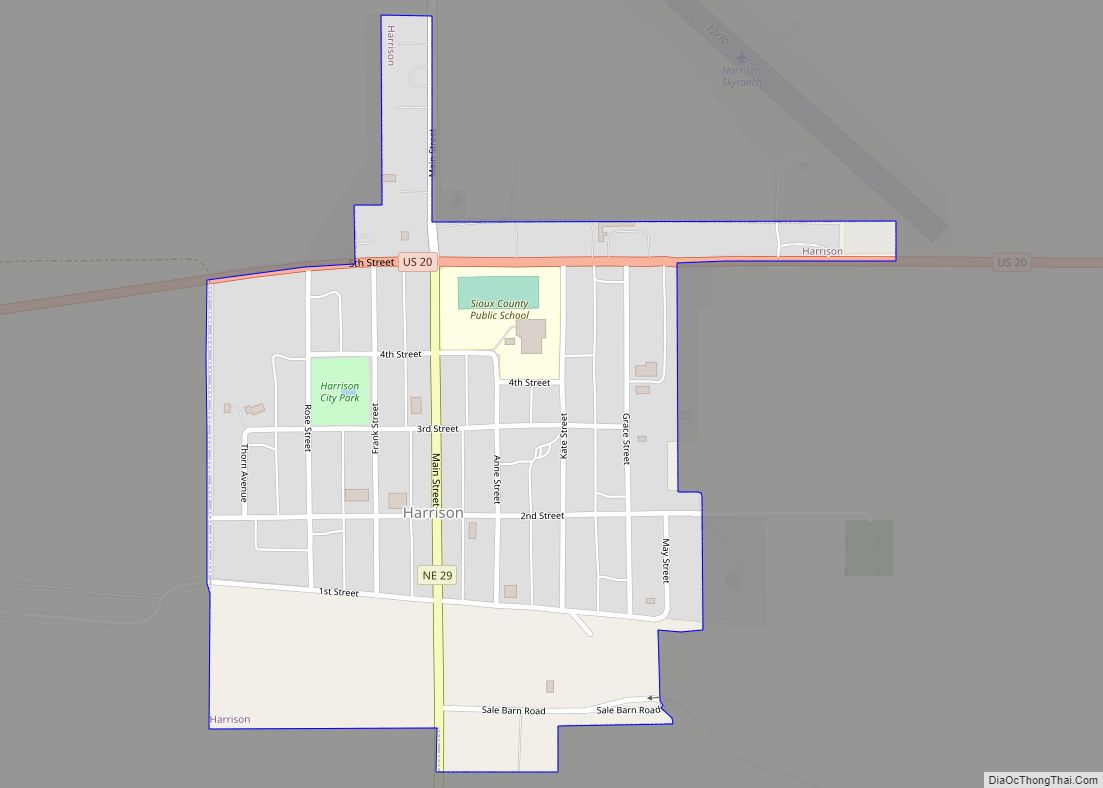
Harrison is a village in Sioux County, Nebraska, United States. The population was 239 at the 2020 census. It is the county seat of Sioux County. Harrison village overview: Name: Harrison village LSAD Code: 47 LSAD Description: village (suffix) State: Nebraska County: Sioux County Elevation: 4,866 ft (1,483 m) Total Area: 0.31 sq mi (0.79 km²) Land Area: 0.31 sq mi (0.79 km²) ... Read more
Map of Harrison village, Nebraska
Map of Harrisburg CDP, Nebraska
Harrisburg is a rural small town in, and the county seat of, Banner County, Nebraska, United States. The population was 100 at the 2010 census. Harrisburg CDP overview: Name: Harrisburg CDP LSAD Code: 57 LSAD Description: CDP (suffix) State: Nebraska County: Banner County Elevation: 4,491 ft (1,369 m) Total Area: 6.47 sq mi (16.76 km²) Land Area: 6.47 sq mi (16.76 km²) Water ... Read more
Map of Harrisburg CDP, Nebraska
Map of Hardy village, Nebraska
Hardy is a village in Nuckolls County, Nebraska, United States. The population was 159 at the 2010 census. Hardy village overview: Name: Hardy village LSAD Code: 47 LSAD Description: village (suffix) State: Nebraska County: Nuckolls County Elevation: 1,555 ft (474 m) Total Area: 0.61 sq mi (1.57 km²) Land Area: 0.61 sq mi (1.57 km²) Water Area: 0.00 sq mi (0.00 km²) Total Population: 97 Population ... Read more
Map of Hardy village, Nebraska
Map of Harbine village
Harbine is a village in Jefferson County, Nebraska, United States. The population was 54 at the 2020 census. Harbine village overview: Name: Harbine village LSAD Code: 47 LSAD Description: village (suffix) State: Nebraska County: Jefferson County Elevation: 1,440 ft (439 m) Total Area: 0.10 sq mi (0.27 km²) Land Area: 0.10 sq mi (0.27 km²) Water Area: 0.00 sq mi (0.00 km²) Total Population: 54 Population ... Read more
Map of Harbine village
Map of Hampton village, Nebraska
Hampton is a village in Hamilton County, in the state of Nebraska in the Midwestern United States. The population was 423 at the 2010 census. Hampton village overview: Name: Hampton village LSAD Code: 47 LSAD Description: village (suffix) State: Nebraska County: Hamilton County Elevation: 1,762 ft (537 m) Total Area: 0.35 sq mi (0.90 km²) Land Area: 0.35 sq mi (0.90 km²) Water ... Read more
Map of Hampton village, Nebraska
Map of Hamlet village, Nebraska
Hamlet is a hamlet in Hayes County, Nebraska, United States. The population was 57 at the 2010 census. A granary is located there, also an elementary school and a community hall, and two churches; otherwise, no other services or businesses. Hamlet village overview: Name: Hamlet village LSAD Code: 47 LSAD Description: village (suffix) State: Nebraska ... Read more
Map of Hamlet village, Nebraska
Map of Halsey village, Nebraska
Halsey is a village in Blaine and Thomas counties in the State of Nebraska. The population was 76 at the 2010 census. Halsey village overview: Name: Halsey village LSAD Code: 47 LSAD Description: village (suffix) State: Nebraska County: Blaine County, Thomas County Elevation: 2,697 ft (822 m) Total Area: 0.19 sq mi (0.50 km²) Land Area: 0.19 sq mi (0.50 km²) Water Area: ... Read more
Map of Halsey village, Nebraska
Map of Hallam village, Nebraska
Hallam is a village in Lancaster County, Nebraska, United States. It is part of the Lincoln, Nebraska Metropolitan Statistical Area. The population was 268 at the 2020 census. Hallam village overview: Name: Hallam village LSAD Code: 47 LSAD Description: village (suffix) State: Nebraska County: Lancaster County Elevation: 1,486 ft (453 m) Total Area: 0.21 sq mi (0.56 km²) Land Area: ... Read more
Map of Hallam village, Nebraska
Map of Hayes Center village
Hayes Center is a village in Hayes County, Nebraska, United States, which has served as that county’s county seat since 1885. Its population, according to the 2010 U.S. census, was 214. Hayes Center village overview: Name: Hayes Center village LSAD Code: 47 LSAD Description: village (suffix) State: Nebraska County: Hayes County Elevation: 3,045 ft (928 m) Total ... Read more
Map of Hayes Center village
Map of Hay Springs village
Hay Springs is a city in Sheridan County in the state of Nebraska, in the Great Plains region of the United States. The population was 570 at the 2010 census. Hay Springs village overview: Name: Hay Springs village LSAD Code: 47 LSAD Description: village (suffix) State: Nebraska County: Sheridan County Elevation: 3,839 ft (1,170 m) Total Area: ... Read more
Map of Hay Springs village
Map of Hastings city, Nebraska
Hastings is a city and the county seat of Adams County, Nebraska, United States. The population was 25,152 at the 2020 census. Edwin Perkins invented Kool-Aid in Hastings in 1927; the town celebrates the invention with the Kool-Aid Days festival every August. During World War II, Hastings operated the largest Naval Ammunition Depot in the ... Read more
Map of Hastings city, Nebraska
Map of Henry village, Nebraska
Henry is a village in Scotts Bluff County, Nebraska, United States. It is part of the Scottsbluff, Nebraska Micropolitan Statistical Area. The population was 106 at the 2010 census. Henry village overview: Name: Henry village LSAD Code: 47 LSAD Description: village (suffix) State: Nebraska County: Scotts Bluff County Elevation: 4,039 ft (1,231 m) Total Area: 0.31 sq mi (0.80 km²) ... Read more
Map of Henry village, Nebraska