Map of Norfolk city, Nebraska
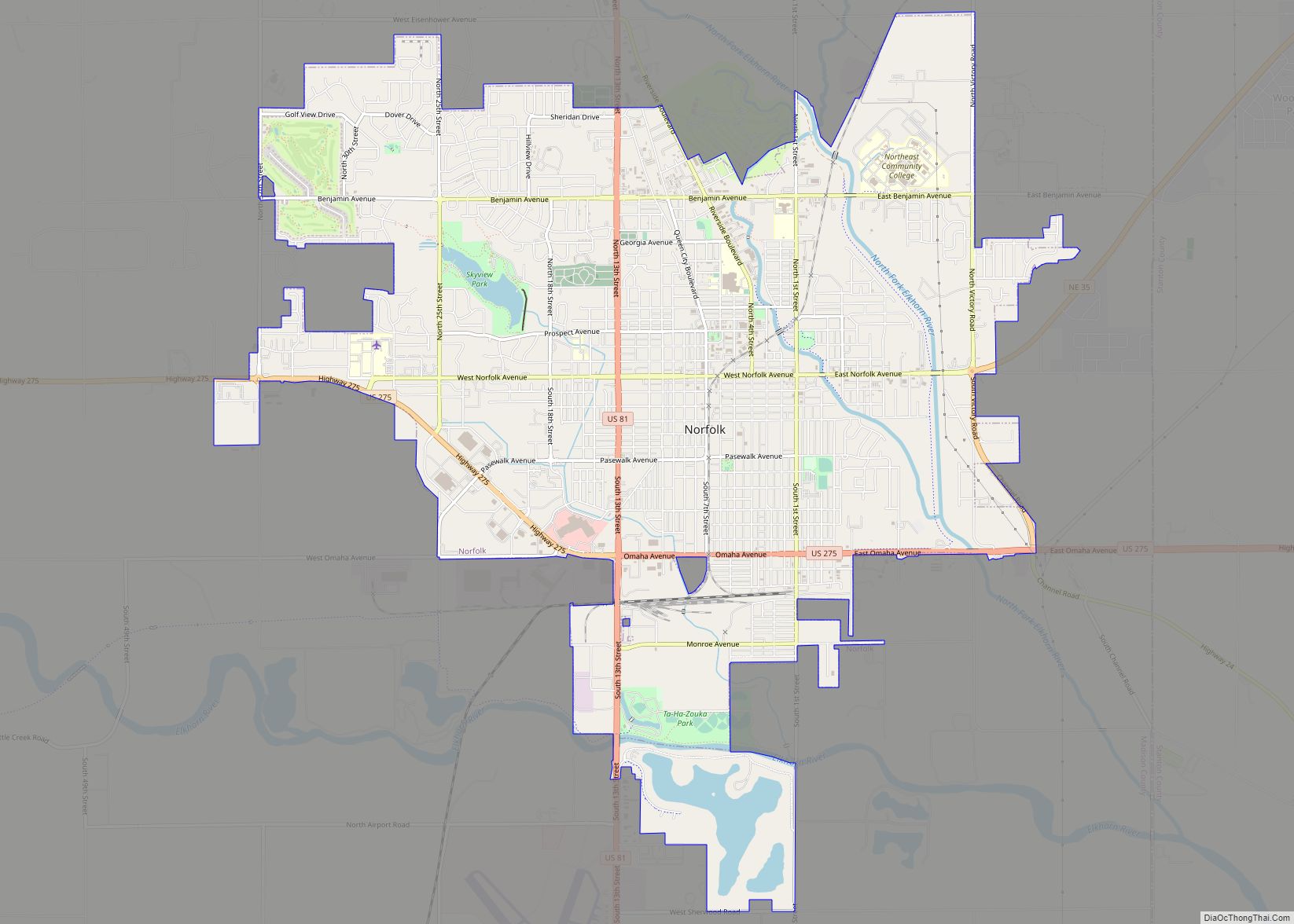
Norfolk (/ˈnɔːrfɔːrk/ or /ˈnɔːrfoʊk/) is a city in Madison County, Nebraska, United States, 113 miles northwest of Omaha and 83 miles west of Sioux City at the intersection of U.S. Routes 81 and 275. The population was 24,210 at the 2010 census, making it the ninth-largest city in Nebraska. It is the principal city of ... Read more
Map of Norfolk city, Nebraska
Map of Nora village, Nebraska
Nora is a village in Nuckolls County, Nebraska, United States. The population was 21 at the 2010 census. Nora village overview: Name: Nora village LSAD Code: 47 LSAD Description: village (suffix) State: Nebraska County: Nuckolls County Elevation: 1,752 ft (534 m) Total Area: 0.38 sq mi (0.98 km²) Land Area: 0.38 sq mi (0.98 km²) Water Area: 0.00 sq mi (0.00 km²) Total Population: 21 Population ... Read more
Map of Nora village, Nebraska
Map of Niobrara village
Niobrara (/ˌnaɪ.əˈbrærə/; Omaha: Ní Ubthátha Tʰáⁿwaⁿgthaⁿ [nĩꜜ ubɫᶞaꜜɫᶞa tʰãꜜwãŋɡɫᶞã], meaning “water spread-out village”) is a village in Knox County, Nebraska, United States. The population was 363 at the 2020 census. Niobrara village overview: Name: Niobrara village LSAD Code: 47 LSAD Description: village (suffix) State: Nebraska County: Knox County Elevation: 1,230 ft (375 m) Total Area: 0.73 sq mi (1.89 km²) ... Read more
Map of Niobrara village
Map of Nickerson village, Nebraska
Nickerson is a village in Dodge County, Nebraska, United States. The population was 369 at the 2010 census. Nickerson village overview: Name: Nickerson village LSAD Code: 47 LSAD Description: village (suffix) State: Nebraska County: Dodge County Elevation: 1,201 ft (366 m) Total Area: 0.38 sq mi (0.99 km²) Land Area: 0.38 sq mi (0.98 km²) Water Area: 0.00 sq mi (0.01 km²) Total Population: 312 Population ... Read more
Map of Nickerson village, Nebraska
Map of Octavia village
Octavia is a village in Butler County, Nebraska, United States. The city had 127 residents as of 2010 census, according to the United States Census Bureau. Octavia village overview: Name: Octavia village LSAD Code: 47 LSAD Description: village (suffix) State: Nebraska County: Butler County Elevation: 1,411 ft (430 m) Total Area: 0.16 sq mi (0.43 km²) Land Area: 0.16 sq mi (0.43 km²) ... Read more
Map of Octavia village
Map of Oconto village, Nebraska
Oconto is a village in Custer County, Nebraska, United States. The population was 151 at the 2010 census. Oconto village overview: Name: Oconto village LSAD Code: 47 LSAD Description: village (suffix) State: Nebraska County: Custer County Founded: 1887 Incorporated: 1906 Elevation: 2,575 ft (785 m) Total Area: 0.20 sq mi (0.53 km²) Land Area: 0.20 sq mi (0.53 km²) Water Area: 0.00 sq mi (0.00 km²) ... Read more
Map of Oconto village, Nebraska
Map of Obert village
Obert is a village in Cedar County, Nebraska, United States. The population was 23 at the 2020 census. Obert village overview: Name: Obert village LSAD Code: 47 LSAD Description: village (suffix) State: Nebraska County: Cedar County Elevation: 1,342 ft (409 m) Total Area: 0.07 sq mi (0.19 km²) Land Area: 0.07 sq mi (0.19 km²) Water Area: 0.00 sq mi (0.00 km²) Total Population: 23 Population ... Read more
Map of Obert village
Map of Oakland city, Nebraska
Oakland is a city in Burt County, Nebraska, United States. The population was 1,244 at the 2010 census. Oakland continues to build on its strong foundation with its bi-annual Swedish Festival and is known by its proclamation from the Swedish Consul-General and the Governor of Nebraska as the “Swedish Capital of Nebraska.” Oakland city overview: ... Read more
Map of Oakland city, Nebraska
Map of Oakdale village, Nebraska
Oakdale is a village in Antelope County, Nebraska, United States. The population was 322 at the 2010 census. Oakdale village overview: Name: Oakdale village LSAD Code: 47 LSAD Description: village (suffix) State: Nebraska County: Antelope County Elevation: 1,716 ft (523 m) Total Area: 0.52 sq mi (1.35 km²) Land Area: 0.52 sq mi (1.35 km²) Water Area: 0.00 sq mi (0.00 km²) Total Population: 276 Population ... Read more
Map of Oakdale village, Nebraska
Map of Ohiowa village
Ohiowa is a village in Fillmore County, Nebraska, United States. The population was 122 at the 2020 census. Ohiowa village overview: Name: Ohiowa village LSAD Code: 47 LSAD Description: village (suffix) State: Nebraska County: Fillmore County Elevation: 1,588 ft (484 m) Total Area: 0.25 sq mi (0.65 km²) Land Area: 0.25 sq mi (0.65 km²) Water Area: 0.00 sq mi (0.00 km²) Total Population: 122 Population ... Read more
Map of Ohiowa village
Map of Ogallala city
Ogallala is a city in and the county seat of Keith County, Nebraska, United States. The population was 4,737 at the 2010 census. In the days of the Nebraska Territory, the city was a stop on the Pony Express and later along the transcontinental railroad. The Ogallala Aquifer was named after the city. Ogallala city ... Read more
Map of Ogallala city
Map of Offutt AFB CDP
Offutt AFB CDP overview: Name: Offutt AFB CDP LSAD Code: 57 LSAD Description: CDP (suffix) State: Nebraska County: Sarpy County FIPS code: 3135875 Online Interactive Map Offutt AFB online map. Source: Basemap layers from Google Map, Open Street Map (OSM), Arcgisonline, Wmflabs. Boundary Data from Database of Global Administrative Areas. Offutt AFB location map. Where ... Read more
Map of Offutt AFB CDP