Map of Sidney city, Nebraska
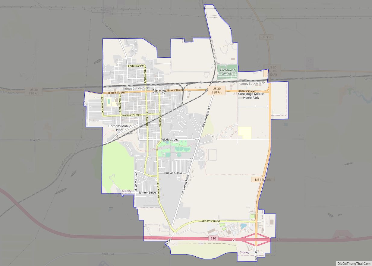
Sidney is a city in and the county seat of Cheyenne County, Nebraska, United States. The city is nine miles (14 km) north of the Colorado state line. The population was 6,757 at the 2010 census. Sidney city overview: Name: Sidney city LSAD Code: 25 LSAD Description: city (suffix) State: Nebraska County: Cheyenne County Elevation: 4,088 ft ... Read more
Map of Sidney city, Nebraska
Map of Shubert village
Shubert is a village in Richardson County, Nebraska, United States. The population was 163 at the 2020 census. Shubert village overview: Name: Shubert village LSAD Code: 47 LSAD Description: village (suffix) State: Nebraska County: Richardson County Elevation: 1,129 ft (344 m) Total Area: 0.21 sq mi (0.54 km²) Land Area: 0.21 sq mi (0.54 km²) Water Area: 0.00 sq mi (0.00 km²) Total Population: 163 Population ... Read more
Map of Shubert village
Map of Sprague village, Nebraska
Sprague is a village in Lancaster County, Nebraska, United States. It is part of the Lincoln, Nebraska Metropolitan Statistical Area. The population was 136 at the 2020 census. Sprague village overview: Name: Sprague village LSAD Code: 47 LSAD Description: village (suffix) State: Nebraska County: Lancaster County Elevation: 1,289 ft (393 m) Total Area: 0.10 sq mi (0.26 km²) Land Area: ... Read more
Map of Sprague village, Nebraska
Map of Spencer village, Nebraska
Spencer is a village in Boyd County, Nebraska, United States. The population was 455 at the 2010 census, down from 541 in 2000. Spencer village overview: Name: Spencer village LSAD Code: 47 LSAD Description: village (suffix) State: Nebraska County: Boyd County Elevation: 1,686 ft (514 m) Total Area: 0.60 sq mi (1.55 km²) Land Area: 0.60 sq mi (1.55 km²) Water Area: 0.00 sq mi ... Read more
Map of Spencer village, Nebraska
Map of Spalding village
Spalding is a village in Greeley County, Nebraska, United States. The population was 408 at the 2020 census. Spalding village overview: Name: Spalding village LSAD Code: 47 LSAD Description: village (suffix) State: Nebraska County: Greeley County Elevation: 1,909 ft (582 m) Total Area: 0.32 sq mi (0.83 km²) Land Area: 0.32 sq mi (0.83 km²) Water Area: 0.00 sq mi (0.00 km²) Total Population: 408 Population ... Read more
Map of Spalding village
Map of South Sioux City
South Sioux City is a city in Dakota County, Nebraska, United States. It is located immediately across the Missouri River from Sioux City, Iowa, and is part of the Sioux City, IA-NE-SD Metropolitan Statistical Area. As of the 2010 census, the city population was 13,353, making it the 14th largest city in Nebraska. South Sioux ... Read more
Map of South Sioux City
Map of South Bend village, Nebraska
South Bend is a village in Cass County, Nebraska, United States. The population was 92 at the 2020 census. The main landmark is a pedestrian bridge across the Platte River which leads to Schramm Park State Recreation Area. It was built in 2004 on the pillars of the abandoned Rock Island Railroad bridge. Thirty-five trains ... Read more
Map of South Bend village, Nebraska
Map of Snyder village, Nebraska
Snyder is a village in Dodge County, Nebraska, United States. The population was 300 at the 2010 census. Snyder village overview: Name: Snyder village LSAD Code: 47 LSAD Description: village (suffix) State: Nebraska County: Dodge County Elevation: 1,342 ft (409 m) Total Area: 0.48 sq mi (1.26 km²) Land Area: 0.48 sq mi (1.26 km²) Water Area: 0.00 sq mi (0.00 km²) Total Population: 254 Population ... Read more
Map of Snyder village, Nebraska
Map of Stapleton village, Nebraska
Stapleton is a village in and the county seat of Logan County, Nebraska, United States. The population was 267 at the 2020 census. Stapleton is part of the North Platte, Nebraska Micropolitan Statistical Area. Stapleton village overview: Name: Stapleton village LSAD Code: 47 LSAD Description: village (suffix) State: Nebraska County: Logan County Elevation: 2,904 ft (885 m) ... Read more
Map of Stapleton village, Nebraska
Map of Staplehurst village
Staplehurst is a village in Seward County, Nebraska, United States. It is part of the Lincoln, Nebraska Metropolitan Statistical Area. The population was 242 at the 2010 census. Staplehurst village overview: Name: Staplehurst village LSAD Code: 47 LSAD Description: village (suffix) State: Nebraska County: Seward County Elevation: 1,486 ft (453 m) Total Area: 0.13 sq mi (0.32 km²) Land Area: ... Read more
Map of Staplehurst village
Map of Stanton city, Nebraska
Stanton is a city in Stanton County, Nebraska, United States. The population was 1,577 at the 2010 census. It is the county seat of Stanton County. Stanton was platted in 1870. Both the city and county are named after Edwin Stanton, secretary of war for president Abraham Lincoln during the American Civil War. Stanton city ... Read more
Map of Stanton city, Nebraska
Map of Stamford village, Nebraska
Stamford is a village in Harlan County, Nebraska, United States. The population was 183 at the 2010 census. Stamford village overview: Name: Stamford village LSAD Code: 47 LSAD Description: village (suffix) State: Nebraska County: Harlan County Elevation: 2,047 ft (624 m) Total Area: 0.47 sq mi (1.23 km²) Land Area: 0.47 sq mi (1.23 km²) Water Area: 0.00 sq mi (0.00 km²) Total Population: 158 Population ... Read more
Map of Stamford village, Nebraska