Map of Troy city, New York
Troy is a city in the U.S. state of New York and the county seat of Rensselaer County. The city is located on the western edge of Rensselaer County and on the eastern bank of the Hudson River. Troy has close ties to the nearby cities of Albany and Schenectady, forming a region popularly called ... Read more
Map of Troy city, New York
Map of Tribes Hill CDP
Tribes Hill is a census-designated place (CDP) located in the Towns of Mohawk (80%) and Amsterdam (20%) in Montgomery County, New York, United States. The population was 1,003 at the 2010 census. One theory is the name is based on this location having been a gathering spot for the Mohawk nation, the dominant Iroquois tribe ... Read more
Map of Tribes Hill CDP
Map of Unadilla village, New York
Unadilla is a village located in the Town of Unadilla in Otsego County, New York, United States. The population was 1,128 at the 2010 census. The Village of Unadilla is located in the southern part of the town, southwest of Oneonta. The community refers to itself as “The Village Beautiful.” Unadilla village overview: Name: Unadilla ... Read more
Map of Unadilla village, New York
Map of Tuxedo Park village
Tuxedo Park is a village in Orange County, New York, United States. Its population was 645 at the 2020 census. It is part of the Poughkeepsie–Newburgh–Middletown metropolitan area as well as the larger New York metropolitan area. Its name is derived from an indigenous Lenape word of the Munsee language, tucsedo or p’tuxseepu, which is ... Read more
Map of Tuxedo Park village
Map of Tuscarora CDP, New York
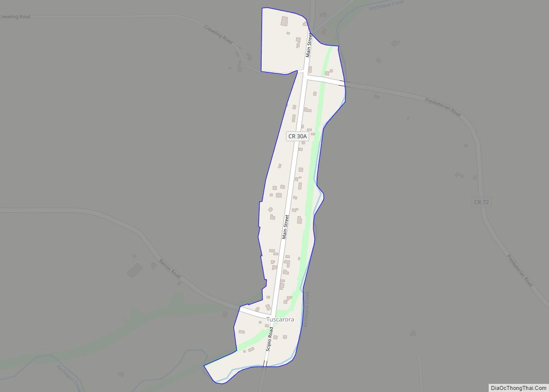
Tuscarora is a hamlet and census-designated place in the town of Mount Morris, Livingston County, New York, United States. Its population was 74 as of the 2010 census. Tuscarora CDP overview: Name: Tuscarora CDP LSAD Code: 57 LSAD Description: CDP (suffix) State: New York County: Livingston County Elevation: 750 ft (230 m) Total Area: 0.09 sq mi (0.24 km²) Land ... Read more
Map of Tuscarora CDP, New York
Map of Turin village, New York
Turin is a village in Lewis County, New York, United States. The village is within the town of Turin and is north of the city of Rome. As of the 2010 census, the village population was 232. Turin village overview: Name: Turin village LSAD Code: 47 LSAD Description: village (suffix) State: New York County: Lewis ... Read more
Map of Turin village, New York
Map of Tupper Lake village
Tupper Lake is a village in Franklin County, New York, United States. The population was 3,282 at the 2020 census. The village is located within the boundaries of the Adirondack Park, west of Lake Placid. Along with nearby Saranac Lake, these three villages make up what is known as the Tri-Lakes region. The village of ... Read more
Map of Tupper Lake village
Map of Tully village
Tully is a village in Onondaga County, New York, United States. As of the 2020 census, the population was 904. The name of the village is derived from that of Roman orator Marcus Tullius Cicero. The village of Tully is in the southeastern part of the town of Tully and is south of Syracuse. Tully ... Read more
Map of Tully village
Map of Valatie village
Valatie (/vəˈleɪʃə/; və-LAY-shə) is a village with several waterfalls in Columbia County, New York, United States. The population was 1,819 at the 2010 census. The village is at the center of the town of Kinderhook on US 9. Valatie village overview: Name: Valatie village LSAD Code: 47 LSAD Description: village (suffix) State: New York County: ... Read more
Map of Valatie village
Map of Vails Gate CDP
Vails Gate is a hamlet (and census-designated place) in Orange County, New York, United States. The population was 3,368 at the 2020 census. It is part of the Poughkeepsie–Newburgh–Middletown, NY Metropolitan Statistical Area as well as the larger New York–Newark–Bridgeport, NY-NJ–CT–PA Combined Statistical Area. Vails Gate is in the southern part of the Town of ... Read more
Map of Vails Gate CDP
Map of Utica city, New York
Utica (/ˈjuːtɪkə/ (listen)) is a city in the Mohawk Valley and the county seat of Oneida County, New York, United States. The tenth-most-populous city in New York State, its population was 65,283 in the 2020 U.S. Census. Located on the Mohawk River at the foot of the Adirondack Mountains, it is approximately 95 mi (153 km) west-northwest ... Read more
Map of Utica city, New York
Map of Upper Nyack village
Upper Nyack is a village incorporated in 1872 in the town of Clarkstown, Rockland County, New York, United States. It is located north of the village of Nyack, east of Valley Cottage, south of Rockland Lake State Park, and west of the Hudson River. The population was 2,063 at the 2010 census. Upper Nyack has ... Read more
Map of Upper Nyack village