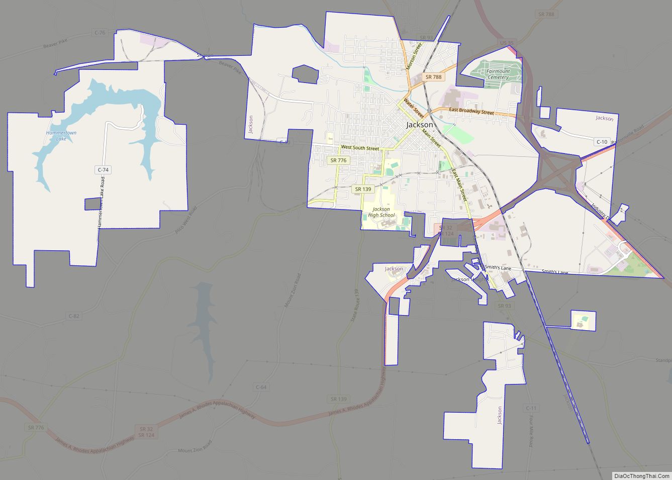
Map of Ironton city, Ohio
Ironton is a city in and the county seat of Lawrence County, Ohio, United States. Located in southernmost Ohio along the Ohio River, it is 20 miles (32 km) northwest of Huntington, West Virginia. The population was 10,571 at the 2020 census. Ironton is part of the Huntington–Ashland metropolitan area. The city’s name is a contraction ... Read more
Map of Ironton city, Ohio
Map of Jenera village
Jenera is a village in Hancock County, Ohio, United States. The population was 221 at the 2010 census. Jenera village overview: Name: Jenera village LSAD Code: 47 LSAD Description: village (suffix) State: Ohio County: Hancock County Elevation: 853 ft (260 m) Total Area: 0.27 sq mi (0.69 km²) Land Area: 0.27 sq mi (0.69 km²) Water Area: 0.00 sq mi (0.00 km²) Total Population: 257 Population ... Read more
Map of Jenera village
Map of Jeffersonville village, Ohio
Jeffersonville is a village in Fayette County, Ohio, United States. The population was 1,203 at the 2010 census. Jeffersonville village overview: Name: Jeffersonville village LSAD Code: 47 LSAD Description: village (suffix) State: Ohio County: Fayette County Elevation: 1,050 ft (320 m) Total Area: 1.71 sq mi (4.42 km²) Land Area: 1.67 sq mi (4.33 km²) Water Area: 0.04 sq mi (0.09 km²) Total Population: 1,258 Population ... Read more
Map of Jeffersonville village, Ohio
Map of Jefferson village, Ohio
Jefferson is a village in and the county seat of Ashtabula County, Ohio, United States. The population was 3,226 at the 2020 census. It is part of the Ashtabula micropolitan area, 50 miles (80 km) northeast of Cleveland. Modern-day Jefferson sports the world’s only perambulator museum and a historical complex including several restored 19th-century buildings. Joshua ... Read more
Map of Jefferson village, Ohio
Map of Kelleys Island village
Kelleys Island is both a village in Erie County, Ohio, and the island which it fully occupies in Lake Erie. The British originally called it Sandusky Island. Later the United States took it over and officially designated it as Island Number 6 and Cunningham Island. It was renamed as Kelleys Island in 1840 by brothers ... Read more
Map of Kelleys Island village
Map of Kansas CDP, Ohio
Kansas is a census-designated place in northwestern Liberty Township, Seneca County, Ohio, United States. It has a post office with the ZIP code 44841. It is located along State Route 635. Kansas was platted in early 1855 along a line of the Lake Erie and Louisville Railroad. The community took its name from the Kansas ... Read more
Map of Kansas CDP, Ohio
Map of Kanauga CDP
Kanauga is an unincorporated community and census-designated place (CDP) in Gallia County, Ohio, United States. As of the 2010 census it had a population of 175. Kanauga CDP overview: Name: Kanauga CDP LSAD Code: 57 LSAD Description: CDP (suffix) State: Ohio County: Gallia County Elevation: 570 ft (170 m) Total Area: 0.32 sq mi (0.83 km²) Land Area: 0.29 sq mi (0.75 km²) ... Read more
Map of Kanauga CDP
Map of Kalida village
Kalida is a village in Putnam County, Ohio, United States. The population was 1,542 at the 2010 census. Kalida village overview: Name: Kalida village LSAD Code: 47 LSAD Description: village (suffix) State: Ohio County: Putnam County Elevation: 725 ft (221 m) Total Area: 1.70 sq mi (4.39 km²) Land Area: 1.68 sq mi (4.35 km²) Water Area: 0.01 sq mi (0.04 km²) Total Population: 1,455 Population ... Read more
Map of Kalida village
Map of Junction City village, Ohio
Junction City is a village in Perry County, Ohio, United States. The population was 721 at the 2020 census. Junction City village overview: Name: Junction City village LSAD Code: 47 LSAD Description: village (suffix) State: Ohio County: Perry County Elevation: 833 ft (254 m) Total Area: 0.65 sq mi (1.68 km²) Land Area: 0.64 sq mi (1.67 km²) Water Area: 0.01 sq mi (0.01 km²) Total ... Read more
Map of Junction City village, Ohio
Map of Johnstown village, Ohio
Johnstown is a city in Licking County, Ohio, United States. The population was 5,182 at the 2020 census. The city is currently served by a seven-person City Council which includes the current Mayor Donald D. Barnard, Jr. Johnstown was the home of William A. Ashbrook, an American businessman, newspaper publisher, and Democratic politician from Ohio. ... Read more
Map of Johnstown village, Ohio
Map of Jewett village, Ohio
Jewett is a village in Harrison County, Ohio, United States. The population was 692 at the 2010 census. Jewett village overview: Name: Jewett village LSAD Code: 47 LSAD Description: village (suffix) State: Ohio County: Harrison County Elevation: 994 ft (303 m) Total Area: 0.51 sq mi (1.32 km²) Land Area: 0.51 sq mi (1.32 km²) Water Area: 0.00 sq mi (0.00 km²) Total Population: 554 Population ... Read more
Map of Jewett village, Ohio
Map of Jerusalem village
Jerusalem is a village in Monroe County, Ohio, United States. The population was 121 at the 2020 census. Jerusalem village overview: Name: Jerusalem village LSAD Code: 47 LSAD Description: village (suffix) State: Ohio County: Monroe County Elevation: 1,263 ft (385 m) Total Area: 0.24 sq mi (0.63 km²) Land Area: 0.24 sq mi (0.63 km²) Water Area: 0.00 sq mi (0.00 km²) Total Population: 121 Population ... Read more
Map of Jerusalem village