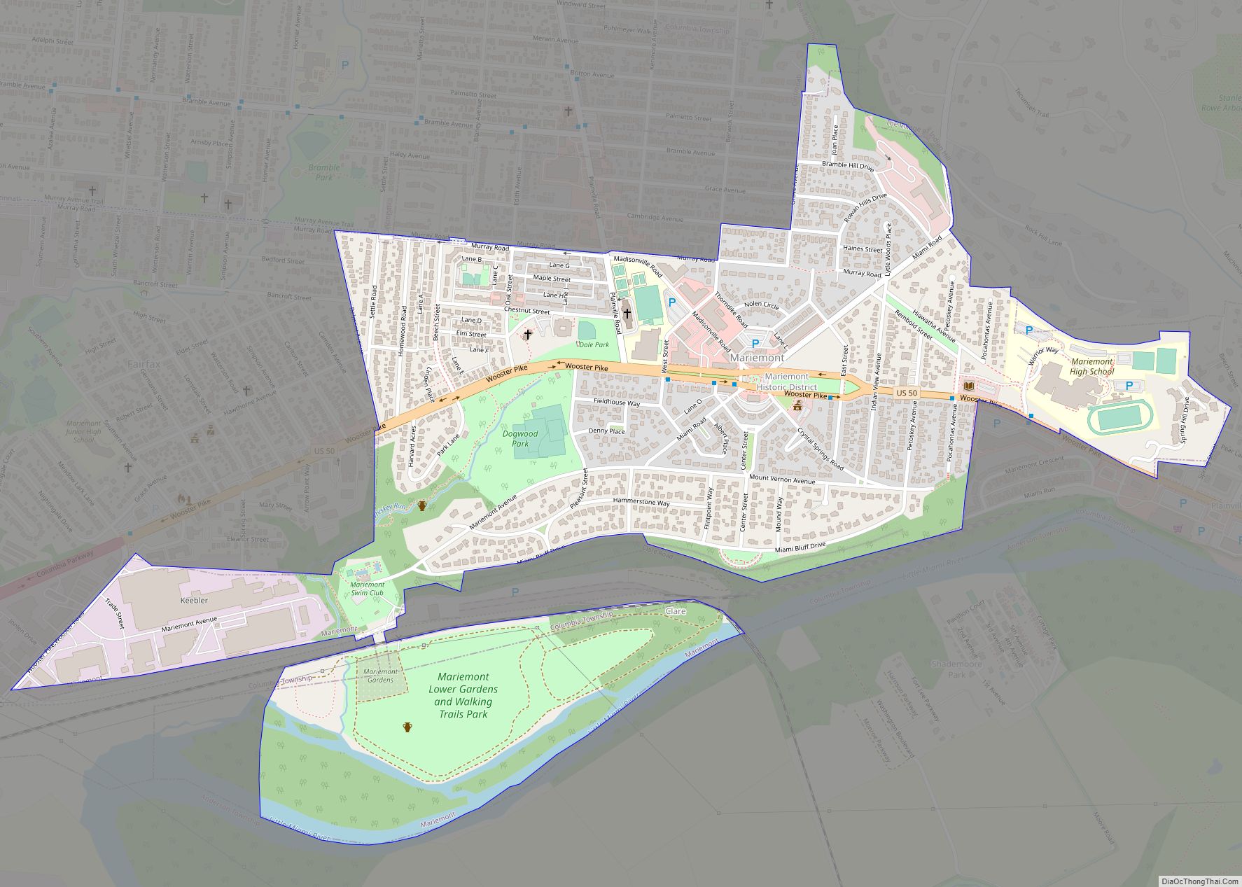
Map of Maplewood Park CDP
Maplewood Park is an unincorporated community and census-designated place in southern Hubbard Township, Trumbull County, Ohio, United States. The population was 243 at the 2020 census. It is part of the Youngstown–Warren metropolitan area. Maplewood Park CDP overview: Name: Maplewood Park CDP LSAD Code: 57 LSAD Description: CDP (suffix) State: Ohio County: Trumbull County Elevation: ... Read more
Map of Maplewood Park CDP
Map of Maple Ridge CDP
Maple Ridge is a census-designated place in southwestern Mahoning County, Ohio, United States, located between Alliance and Sebring. The population was 667 at the 2020 census. It is part of the Youngstown–Warren metropolitan area. Maple Ridge CDP overview: Name: Maple Ridge CDP LSAD Code: 57 LSAD Description: CDP (suffix) State: Ohio County: Mahoning County Elevation: ... Read more
Map of Maple Ridge CDP
Map of Maple Heights city
Maple Heights is a city in Cuyahoga County, Ohio, United States. It is a suburb of Cleveland. The population was 23,701 at the 2020 census. Maple Heights city overview: Name: Maple Heights city LSAD Code: 25 LSAD Description: city (suffix) State: Ohio County: Cuyahoga County Elevation: 896 ft (273 m) Total Area: 5.17 sq mi (13.39 km²) Land Area: 5.17 sq mi ... Read more
Map of Maple Heights city
Map of Mantua village, Ohio
Mantua (/ˈmænəweɪ/ MAN-ə-way) is a village in northern Portage County, Ohio, United States, along the Cuyahoga River. The population was 1,001 at the time of the 2020 census. It is part of the Akron metropolitan area. It was formed from portions of Mantua Township in the Connecticut Western Reserve. Mantua village overview: Name: Mantua village ... Read more
Map of Mantua village, Ohio
Map of Marne CDP, Ohio
Marne is an unincorporated community and census-designated place (CDP) in Licking County, Ohio, United States. As of the 2010 census it had a population of 783. Marne CDP overview: Name: Marne CDP LSAD Code: 57 LSAD Description: CDP (suffix) State: Ohio County: Licking County Elevation: 801 ft (244 m) Total Area: 0.88 sq mi (2.27 km²) Land Area: 0.88 sq mi (2.27 km²) ... Read more
Map of Marne CDP, Ohio
Map of Marlboro CDP, Ohio
Marlboro is an unincorporated community in Stark County, Ohio, United States. Marlboro CDP overview: Name: Marlboro CDP LSAD Code: 57 LSAD Description: CDP (suffix) State: Ohio County: Stark County Elevation: 1,168 ft (356 m) Total Area: 0.43 sq mi (1.12 km²) Land Area: 0.43 sq mi (1.11 km²) Water Area: 0.00 sq mi (0.01 km²) Total Population: 247 Population Density: 574.42/sq mi (221.90/km²) Area code: 234 and ... Read more
Map of Marlboro CDP, Ohio
Map of Massillon city
Massillon is a city in Stark County, Ohio, United States, approximately 8 miles (13 km) west of Canton, 20 miles (32 km) south of Akron, and 50 miles (80 km) south of Cleveland. The population was 32,146 at the 2020 census. Massillon is the second largest city within the Canton–Massillon metropolitan area, which includes all of Stark and ... Read more
Map of Massillon city
Map of Mason city, Ohio
Mason is a city in southwestern Warren County, Ohio, United States, approximately 22 miles (35 km) north of downtown Cincinnati. As of the 2020 census, Mason’s population was 34,792. It is home to Kings Island amusement park and one of the largest tennis stadiums in the world, the Lindner Family Tennis Center, home of the Western ... Read more
Map of Mason city, Ohio
Map of Marysville city, Ohio
Marysville is a city in and the county seat of Union County, Ohio, United States, approximately 27 miles (44 km) northwest of Columbus. The population was 22,094 at the 2010 census, a 38.59% increase from 2000. Marysville’s longtime slogan is “Where the Grass is Greener”. In December 2008, the city was designated as a “Preserve America ... Read more
Map of Marysville city, Ohio
Map of Martinsville village, Ohio
Martinsville is a village in Clinton County, Ohio, United States. The population was 463 at the 2010 census. Martinsville village overview: Name: Martinsville village LSAD Code: 47 LSAD Description: village (suffix) State: Ohio County: Clinton County Elevation: 1,086 ft (331 m) Total Area: 0.37 sq mi (0.96 km²) Land Area: 0.37 sq mi (0.95 km²) Water Area: 0.00 sq mi (0.00 km²) Total Population: 416 Population ... Read more
Map of Martinsville village, Ohio
Map of Martinsburg village, Ohio
Martinsburg is a village in Knox County, Ohio, United States. The population was 237 at the 2010 census. Martinsburg village overview: Name: Martinsburg village LSAD Code: 47 LSAD Description: village (suffix) State: Ohio County: Knox County Elevation: 1,175 ft (358 m) Total Area: 0.18 sq mi (0.46 km²) Land Area: 0.18 sq mi (0.46 km²) Water Area: 0.00 sq mi (0.00 km²) Total Population: 222 Population ... Read more
Map of Martinsburg village, Ohio
Map of Martins Ferry city
Martins Ferry is the largest city in Belmont County, Ohio, United States, along the Ohio River across from Wheeling, West Virginia. The population was 6,260 as of the 2020 census. It is part of the Wheeling metropolitan area. Martins Ferry city overview: Name: Martins Ferry city LSAD Code: 25 LSAD Description: city (suffix) State: Ohio ... Read more
Map of Martins Ferry city