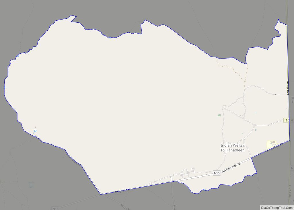
Indian Wells (Navajo: Tó Hahadleeh) is an Census Designated Place in Navajo County, Arizona, United States. Indian Wells Elementary School is located in the town, it serves 600 students. It is also the name of the local Navajo chapter of the Navajo Nation Council. Indian Wells is served by a post office with the ZIP ... Read more
Map of US Cities and Places
Icehouse Canyon is a census-designated place (CDP) in Gila County, Arizona, United States. The population was 677 at the 2010 census. Icehouse Canyon CDP overview: Name: Icehouse Canyon CDP LSAD Code: 57 LSAD Description: CDP (suffix) State: Arizona County: Gila County Elevation: 3,798 ft (1,158 m) Total Area: 4.86 sq mi (12.57 km²) Land Area: 4.86 sq mi (12.57 km²) Water Area: 0.00 sq mi ... Read more
Joseph City (elevation 5,000 ft) is a Census Designated Place located in Navajo County, Arizona, United States. It is located on Interstate 40, approximately eighty miles east of Flagstaff and about thirty-five miles west of Petrified Forest National Park. In 2010, there were 1,386 inhabitants. It is the site of the Jack Rabbit Trading Post, a ... Read more
Jerome is a town in the Black Hills of Yavapai County in the U.S. state of Arizona. Founded in the late 19th century on Cleopatra Hill overlooking the Verde Valley, Jerome is located more than 5,000 feet (1,500 m) above sea level. It is about 100 miles (160 km) north of Phoenix along State Route 89A between ... Read more
Jeddito (Navajo: Jádító) is a census-designated place (CDP) in Navajo County, Arizona, United States. The population was 293 at the 2010 census. Jeddito CDP overview: Name: Jeddito CDP LSAD Code: 57 LSAD Description: CDP (suffix) State: Arizona County: Navajo County Elevation: 6,345 ft (1,934 m) Total Area: 5.42 sq mi (14.04 km²) Land Area: 5.42 sq mi (14.03 km²) Water Area: 0.00 sq mi (0.01 km²) ... Read more
Kaibeto (Navajo: Kʼaiʼbiiʼtó) is a census-designated place (CDP) in Coconino County, Arizona, United States. The population was 1,522 at the 2010 census. Kaibito CDP overview: Name: Kaibito CDP LSAD Code: 57 LSAD Description: CDP (suffix) State: Arizona County: Coconino County Elevation: 5,810 ft (1,771 m) Total Area: 15.90 sq mi (41.18 km²) Land Area: 15.90 sq mi (41.18 km²) Water Area: 0.00 sq mi (0.00 km²) ... Read more
Kaibab is an unincorporated community and census-designated place (CDP) in Mohave County, Arizona, United States. It is within the Kaibab Indian Reservation. The population of the CDP was 140 at the 2020 census. Kaibab CDP overview: Name: Kaibab CDP LSAD Code: 57 LSAD Description: CDP (suffix) State: Arizona County: Mohave County Elevation: 4,991 ft (1,521 m) Total ... Read more
Kachina Village is a census-designated place (CDP) in Coconino County, Arizona, United States. The population was 2,622 at the 2010 census. Kachina Village is primarily a bedroom community for Flagstaff. Kachina Village CDP overview: Name: Kachina Village CDP LSAD Code: 57 LSAD Description: CDP (suffix) State: Arizona County: Coconino County Elevation: 6,774 ft (2,065 m) Total Area: ... Read more
Kaka (O’odham: Gagka, translates as “A Clearing”) is a census-designated place (CDP) in Maricopa County, Arizona, United States, located in the Tohono O’odham Nation. The population was 83 at the 2020 census, down from 141 at the 2010 census. Kaka CDP overview: Name: Kaka CDP LSAD Code: 57 LSAD Description: CDP (suffix) State: Arizona County: ... Read more
Kayenta (Navajo: Tó Dínéeshzheeʼ) is a U.S. town which is part of the Navajo Nation and is in Navajo County, Arizona, United States. Established November 13, 1986, the Kayenta Township is the only “township” existing under the laws of the Navajo Nation, making it unique in this way. The population was 5,189 at the 2010 ... Read more
Katherine is an unincorporated community and census-designated place (CDP) in Mohave County, Arizona, United States. The population was 76 at the 2020 census, down from 103 at the 2010 census. Katherine CDP overview: Name: Katherine CDP LSAD Code: 57 LSAD Description: CDP (suffix) State: Arizona County: Mohave County Elevation: 686 ft (209 m) Total Area: 4.62 sq mi (11.97 km²) ... Read more
Kingman is a city in, and the county seat of, Mohave County, Arizona, United States. It is named after Lewis Kingman, an engineer for the Atlantic and Pacific Railroad. It is located 105 miles (169 km) southeast of Las Vegas, Nevada, and 180 miles (290 km) northwest of Arizona’s state capital, Phoenix. The population was 32,689 at ... Read more