Map of Payson town, Arizona
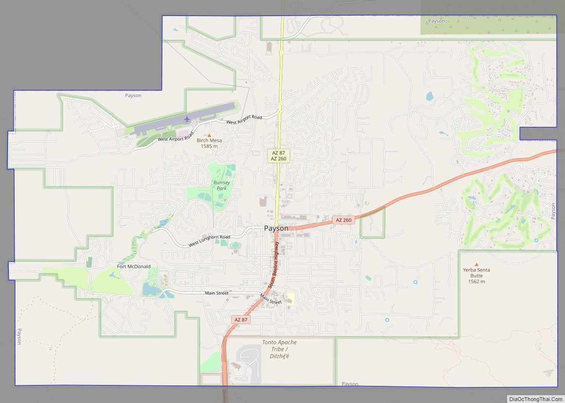
Payson is a town in northern Gila County, Arizona, United States. Due to Payson’s location being very near to the geographic center of Arizona, it has been called “The Heart of Arizona”. The town is surrounded by the Tonto National Forest, the largest of the six national forests in Arizona and is the ninth largest ... Read more
Map of Payson town, Arizona
Map of Paulden CDP
Paulden is a census designated place (CDP) in Yavapai County, Arizona, United States. The population was 5,231 at the 2010 census. Paulden CDP overview: Name: Paulden CDP LSAD Code: 57 LSAD Description: CDP (suffix) State: Arizona County: Yavapai County Elevation: 4,408 ft (1,344 m) Total Area: 57.32 sq mi (148.47 km²) Land Area: 57.32 sq mi (148.47 km²) Water Area: 0.00 sq mi (0.00 km²) Total ... Read more
Map of Paulden CDP
Map of Peridot CDP
Peridot (Western Apache: Tséé Dotłʼizh “Blue Rock”) is an unincorporated community and census-designated place (CDP) in Gila and Graham counties in the U.S. state of Arizona. The population was 1,350 at the 2010 census. Peridot is named for the mineral peridot, found in basalt flows nearby. Peridot CDP overview: Name: Peridot CDP LSAD Code: 57 ... Read more
Map of Peridot CDP
Map of Peeples Valley CDP
Peeples Valley (Yavapai: Wachinivo) is a census-designated place (CDP) in Yavapai County, Arizona, United States. The population was 374 at the 2000 census. Peeples Valley is named for prospector A. H. Peeples, who was the leader of the group that discovered Rich Hill, a gold deposit at Weaver, Arizona, in 1863. Peeples Valley CDP overview: ... Read more
Map of Peeples Valley CDP
Map of Peach Springs CDP
Peach Springs (Walapai: Hàkđugwi:v) is a census-designated place (CDP) in Mohave County, Arizona, United States. The population was 1,098 at the 2020 census. Peach Springs serves as the administrative headquarters of the Hualapai people and is located on the Hualapai Reservation. Peach Springs CDP overview: Name: Peach Springs CDP LSAD Code: 57 LSAD Description: CDP ... Read more
Map of Peach Springs CDP
Map of Pima town
Pima is a town in Graham County, Arizona, United States. As of the 2010 census, the population of the town was 2,387, up from 1,989 in 2000. The estimated population in 2018 was 2,512. Pima is part of the Safford Micropolitan Statistical Area. Despite its name, it is not located in nearby Pima County. This ... Read more
Map of Pima town
Map of Picture Rocks CDP, Arizona
Picture Rocks is a census-designated place (CDP) in Pima County, Arizona, United States, home of the Tucson artifacts. The population was 9,551 at the 2020 United States census. Picture Rocks CDP overview: Name: Picture Rocks CDP LSAD Code: 57 LSAD Description: CDP (suffix) State: Arizona County: Pima County Elevation: 2,080 ft (634 m) Total Area: 70.86 sq mi (183.52 km²) ... Read more
Map of Picture Rocks CDP, Arizona
Map of Picacho CDP
Picacho (/piːkɑːtʃoʊ/) is an unincorporated community and census-designated place in Pinal County, Arizona, United States. The population was 471 at the 2010 census. Picacho is located near Interstate 10, 4.5 miles (7.2 km) southeast of Eloy and 7 miles (11 km) northwest of Picacho Peak State Park. Picacho has a post office with ZIP code 85241, which ... Read more
Map of Picacho CDP
Map of Pine Lake CDP, Arizona
Pine Lake is an unincorporated community and census-designated place (CDP) in Mohave County, Arizona, United States. The population was 142 at the 2020 census. Pine Lake CDP overview: Name: Pine Lake CDP LSAD Code: 57 LSAD Description: CDP (suffix) State: Arizona County: Mohave County Elevation: 6,283 ft (1,915 m) Total Area: 1.69 sq mi (4.37 km²) Land Area: 1.69 sq mi (4.37 km²) ... Read more
Map of Pine Lake CDP, Arizona
Map of Pinal CDP
Pinal is a census-designated place (CDP) in Gila County, Arizona, United States. The population was 439 at the 2010 census. Pinal CDP overview: Name: Pinal CDP LSAD Code: 57 LSAD Description: CDP (suffix) State: Arizona County: Gila County Elevation: 3,800 ft (1,200 m) Total Area: 0.42 sq mi (1.08 km²) Land Area: 0.42 sq mi (1.08 km²) Water Area: 0.00 sq mi (0.00 km²) Total Population: ... Read more
Map of Pinal CDP
Map of Pimaco Two CDP
Pimaco Two is a census-designated place (CDP) located in Pima County, Arizona, United States. The population was 682 at the 2010 census. Pimaco Two CDP overview: Name: Pimaco Two CDP LSAD Code: 57 LSAD Description: CDP (suffix) State: Arizona County: Pima County Elevation: 4,094 ft (1,248 m) Total Area: 4.54 sq mi (11.76 km²) Land Area: 4.54 sq mi (11.76 km²) Water Area: ... Read more
Map of Pimaco Two CDP
Map of Pinetop Country Club CDP
Pinetop Country Club is a census-designated place (CDP) located in Navajo County, Arizona, United States. The population was 1,794 at the 2010 census. Pinetop Country Club CDP overview: Name: Pinetop Country Club CDP LSAD Code: 57 LSAD Description: CDP (suffix) State: Arizona County: Navajo County Elevation: 7,214 ft (2,199 m) Total Area: 6.72 sq mi (17.42 km²) Land Area: 6.72 sq mi ... Read more
Map of Pinetop Country Club CDP