Map of Mentone CDP, Texas
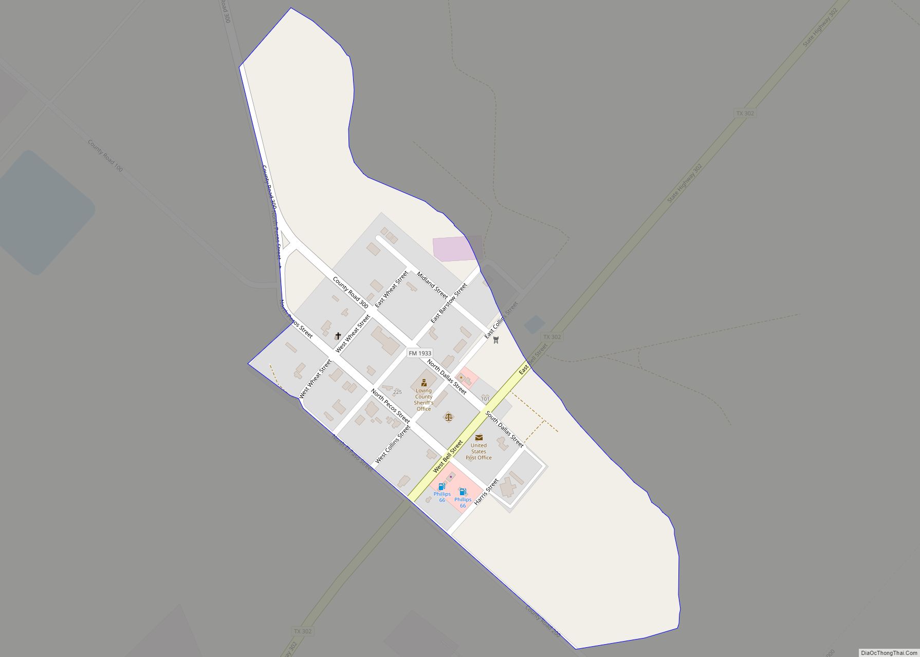
Mentone (/ˌmɛnˈtoʊn/) is an unincorporated small town in, and the county seat of Loving County, Texas, United States. It had a population of 19 in 2010, almost a quarter of the county’s 82 people at the time. Mentone was, until recent years, the least-populated unincorporated county seat in the United States, but lost that distinction ... Read more
Map of Mentone CDP, Texas
Map of Menard city
Menard is a city in and the county seat of Menard County, Texas, United States. Its population was 1,471 at the 2010 census. Menard city overview: Name: Menard city LSAD Code: 25 LSAD Description: city (suffix) State: Texas County: Menard County Elevation: 1,883 ft (574 m) Total Area: 2.06 sq mi (5.34 km²) Land Area: 2.06 sq mi (5.34 km²) Water Area: 0.00 sq mi ... Read more
Map of Menard city
Map of Memphis city, Texas
Memphis is a city and the county seat of Hall County, Texas, United States. As of the 2010 census, the population was 2,290. Memphis city overview: Name: Memphis city LSAD Code: 25 LSAD Description: city (suffix) State: Texas County: Hall County Incorporated: 1906 Elevation: 2,057 ft (627 m) Total Area: 2.24 sq mi (5.81 km²) Land Area: 2.24 sq mi (5.81 km²) Water ... Read more
Map of Memphis city, Texas
Map of Melvin town, Texas
Melvin is a town in McCulloch County, Texas, United States. Its population was 179 at the 2010 census. Melvin town overview: Name: Melvin town LSAD Code: 43 LSAD Description: town (suffix) State: Texas County: McCulloch County Elevation: 1,857 ft (566 m) Total Area: 0.47 sq mi (1.21 km²) Land Area: 0.46 sq mi (1.20 km²) Water Area: 0.00 sq mi (0.01 km²) Total Population: 178 Population ... Read more
Map of Melvin town, Texas
Map of Melissa city
Melissa is a city in Collin County, Texas, United States. The population was 4,695 at the 2010 census, up from 1,350 at the 2000 census; in 2020, its population grew to 13,901. Melissa city overview: Name: Melissa city LSAD Code: 25 LSAD Description: city (suffix) State: Texas County: Collin County Elevation: 679 ft (207 m) Total Area: ... Read more
Map of Melissa city
Map of Mertzon city
Mertzon is a city in and the county seat of Irion County, Texas, United States. Its population was 781 according to the 2010 census. It is part of the San Angelo, Texas, metropolitan statistical area. Mertzon city overview: Name: Mertzon city LSAD Code: 25 LSAD Description: city (suffix) State: Texas County: Irion County Elevation: 2,201 ft ... Read more
Map of Mertzon city
Map of Mertens town
Mertens is a town in Hill County, Texas, United States. It is located along State Highway 22. The population was 125 at the 2010 census. Mertens town overview: Name: Mertens town LSAD Code: 43 LSAD Description: town (suffix) State: Texas County: Hill County Elevation: 538 ft (164 m) Total Area: 0.44 sq mi (1.13 km²) Land Area: 0.43 sq mi (1.13 km²) Water ... Read more
Map of Mertens town
Map of Merkel town
Merkel is a city in Taylor County, Texas, United States. Its population was 2,590 at the 2010 census. It is part of the Abilene metropolitan area. Merkel town overview: Name: Merkel town LSAD Code: 43 LSAD Description: town (suffix) State: Texas County: Taylor County Elevation: 1,870 ft (570 m) Total Area: 2.80 sq mi (7.25 km²) Land Area: 2.80 sq mi (7.25 km²) ... Read more
Map of Merkel town
Map of Mila Doce CDP
Mila Doce (“Mile Twelve” in Spanish, from the name of the road it adjoins) is a census-designated place (CDP) in Hidalgo County, Texas. The population was 6,222 at the 2010 United States Census. It is part of the McAllen–Edinburg–Mission Metropolitan Statistical Area. Mila Doce CDP overview: Name: Mila Doce CDP LSAD Code: 57 LSAD Description: ... Read more
Map of Mila Doce CDP
Map of Mikes CDP
Mikes is a census-designated place (CDP) in Starr County, Texas, United States. This was a new CDP for the 2010 census with a population of 910. Mikes CDP overview: Name: Mikes CDP LSAD Code: 57 LSAD Description: CDP (suffix) State: Texas County: Starr County Total Area: 0.1 sq mi (0.3 km²) Land Area: 0.1 sq mi (0.3 km²) Water Area: 0.0 sq mi ... Read more
Map of Mikes CDP
Map of Miguel Barrera CDP
Miguel Barrera is a census-designated place (CDP) in Starr County, Texas, United States. It is a new CDP formed from part of the La Rosita CDP prior to the 2010 census with a population of 128. Miguel Barrera CDP overview: Name: Miguel Barrera CDP LSAD Code: 57 LSAD Description: CDP (suffix) State: Texas County: Starr ... Read more
Map of Miguel Barrera CDP
Map of Midway city, Texas
Midway is a city in Madison County, Texas, United States at the junction of the La Bahía Road (now Texas State Highway 21) and the Old San Antonio Road in northeastern Madison County. Midway was the birthplace of George McJunkin, who was born a slave. Midway city overview: Name: Midway city LSAD Code: 25 LSAD ... Read more
Map of Midway city, Texas