Map of Ore City
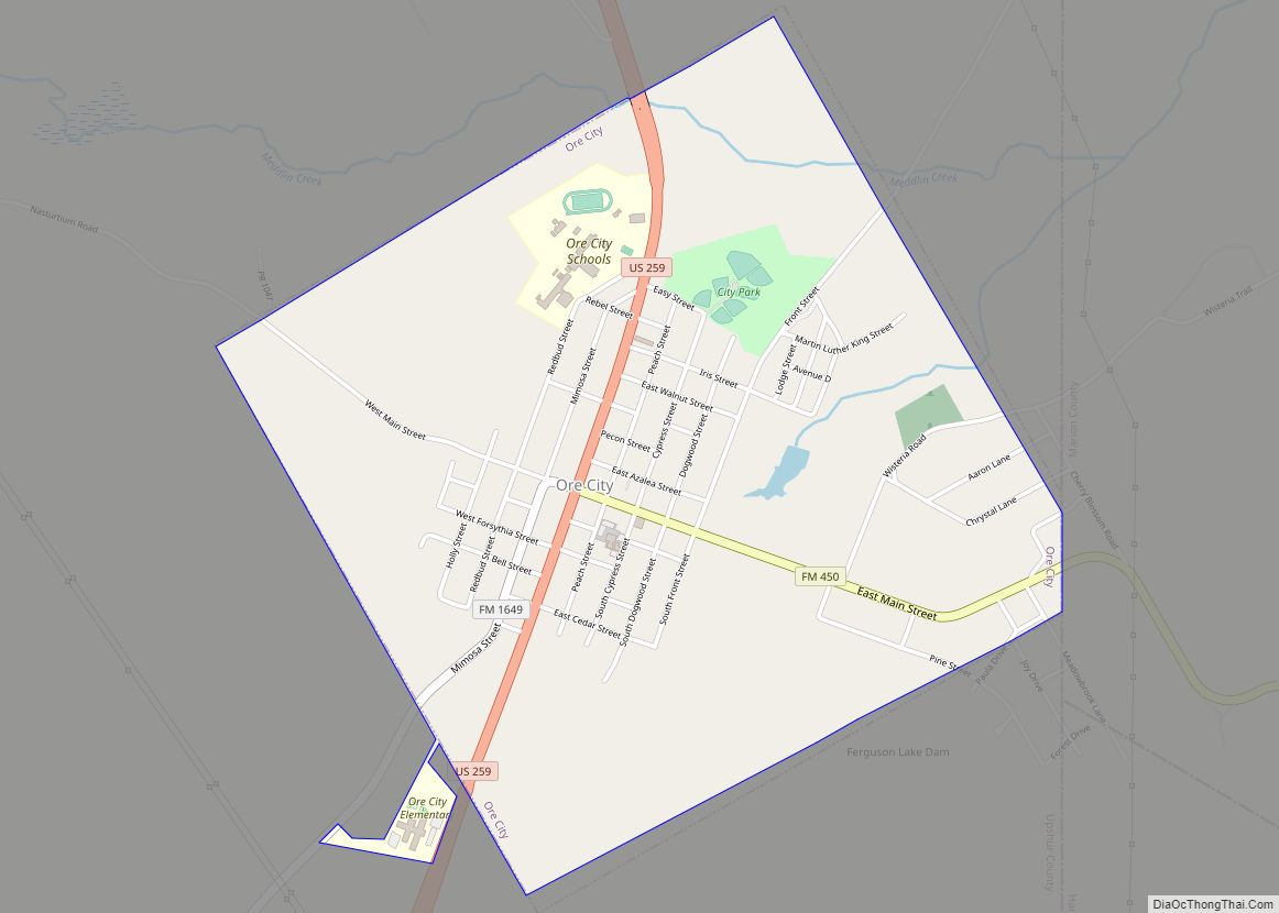
Ore City is a city in Upshur County, Texas, United States. The population was 1,108 at the 2020 census. Ore City city overview: Name: Ore City city LSAD Code: 25 LSAD Description: city (suffix) State: Texas County: Upshur County Elevation: 328 ft (100 m) Total Area: 2.18 sq mi (5.65 km²) Land Area: 2.16 sq mi (5.59 km²) Water Area: 0.02 sq mi (0.06 km²) Total ... Read more
Map of Ore City
Map of Orchard city, Texas
Orchard is a city in western Fort Bend County, Texas, United States, within the Houston–Sugar Land–Baytown metropolitan area. The community is located along State Highway 36 (SH 36) and the BNSF Railway between Rosenberg in Fort Bend County and Wallis in Austin County. The population was 352 at the 2010 census, down from 408 at the 2000 ... Read more
Map of Orchard city, Texas
Map of Palestine city, Texas
Palestine (/ˈpælɪstiːn/ PAL-ih-steen) is a city in and the seat of Anderson County in the U.S. state of Texas. It was named for Palestine, Illinois, by preacher Daniel Parker, who had migrated from that town. It is also contested that Micham Main named Palestine after his hometown of Palestine, Illinois when he and his family ... Read more
Map of Palestine city, Texas
Map of Palacios city
Palacios (/pəˈlæʃəs/ (listen) pə-LASH-əs) is a city in Matagorda County, Texas, United States. The population was 4,395 at the 2020 census. Palacios city overview: Name: Palacios city LSAD Code: 25 LSAD Description: city (suffix) State: Texas County: Matagorda County Elevation: 13 ft (4 m) Total Area: 5.21 sq mi (13.48 km²) Land Area: 4.94 sq mi (12.79 km²) Water Area: 0.27 sq mi (0.69 km²) Total ... Read more
Map of Palacios city
Map of Paisano Park CDP
Paisano Park is a census-designated place (CDP) in San Patricio County, Texas, United States. The population was 130 at the 2010 census. Prior to the 2010 census Paisano Park was part of the Edgewater-Paisano CDP. Paisano Park CDP overview: Name: Paisano Park CDP LSAD Code: 57 LSAD Description: CDP (suffix) State: Texas County: San Patricio ... Read more
Map of Paisano Park CDP
Map of Palo Blanco CDP
Palo Blanco is a census-designated place (CDP) in Starr County, Texas, United States. It is a new CDP formed from part of the Los Alvarez CDP prior to the 2010 census with a population of 204. Palo Blanco CDP overview: Name: Palo Blanco CDP LSAD Code: 57 LSAD Description: CDP (suffix) State: Texas County: Starr ... Read more
Map of Palo Blanco CDP
Map of Palmview city
Palmview is a city in Hidalgo County, Texas. The population is 17,410 as of the 2020 United States Census. It is part of the McAllen–Edinburg–Mission and Reynosa–McAllen metropolitan areas. Palmview city overview: Name: Palmview city LSAD Code: 25 LSAD Description: city (suffix) State: Texas County: Hidalgo County Incorporated: 1978 Elevation: 148.6 ft (45.15 m) Total Area: 7.61 sq mi ... Read more
Map of Palmview city
Map of Palmview South CDP
Palmview South is a census-designated place (CDP) in Hidalgo County, Texas. The population was 5,575 at the 2010 United States Census. It is part of the McAllen–Edinburg–Mission Metropolitan Statistical Area. Palmview South CDP overview: Name: Palmview South CDP LSAD Code: 57 LSAD Description: CDP (suffix) State: Texas County: Hidalgo County Elevation: 135 ft (41 m) Total Area: ... Read more
Map of Palmview South CDP
Map of Palmhurst city
Palmhurst is a city in Hidalgo County, Texas. The population was 2,607 at the 2010 United States Census. It is part of the McAllen–Edinburg–Mission and Reynosa–McAllen metropolitan areas. Palmhurst city overview: Name: Palmhurst city LSAD Code: 25 LSAD Description: city (suffix) State: Texas County: Hidalgo County Elevation: 161 ft (49 m) Total Area: 4.45 sq mi (11.52 km²) Land Area: ... Read more
Map of Palmhurst city
Map of Palmer town, Texas
Palmer is a town in Ellis County, Texas, United States. It is part of the Dallas–Fort Worth metroplex. Its population was 2,393 in 2020. Palmer town overview: Name: Palmer town LSAD Code: 43 LSAD Description: town (suffix) State: Texas County: Ellis County Elevation: 463 ft (141 m) Total Area: 3.15 sq mi (8.16 km²) Land Area: 3.11 sq mi (8.06 km²) Water Area: ... Read more
Map of Palmer town, Texas
Map of Palm Valley city, Texas
Palm Valley is a city in Cameron County, Texas, United States. The population was 1,304 at the 2010 census. It is part of the Brownsville–Harlingen–Raymondville and the Matamoros–Brownsville metropolitan areas. Palm Valley city overview: Name: Palm Valley city LSAD Code: 25 LSAD Description: city (suffix) State: Texas County: Cameron County Incorporated: September 11, 1980 Elevation: ... Read more
Map of Palm Valley city, Texas
Map of Palisades village
Palisades is a village in Randall County, Texas, United States. The population was 325 at the 2010 census. It is part of the Amarillo, Texas Metropolitan Statistical Area. Palisades village overview: Name: Palisades village LSAD Code: 47 LSAD Description: village (suffix) State: Texas County: Randall County Elevation: 3,353 ft (1,022 m) Total Area: 0.58 sq mi (1.50 km²) Land Area: ... Read more
Map of Palisades village