Palestine (/ˈpælɪstiːn/ PAL-ih-steen) is a city in and the seat of Anderson County in the U.S. state of Texas. It was named for Palestine, Illinois, by preacher Daniel Parker, who had migrated from that town. It is also contested that Micham Main named Palestine after his hometown of Palestine, Illinois when he and his family arrived here along with the Parker family and several others.
The city had a 2020 U.S. census population of 18,544, making it the sixth-largest incorporated municipality in Northeast Texas by population. Palestine is a relatively small city located in the Piney Woods, equidistant from the major cities of Dallas, Houston, and Shreveport, Louisiana.
It is notable for its natural environment, and has a notable dogwood blooming season. It has 23 historical sites on the National Register of Historic Places, and was the western terminus of the historic Texas State Railroad. Today this steam-and-diesel railroad museum operates tourist trains between Palestine and Rusk.
| Name: | Palestine city |
|---|---|
| LSAD Code: | 25 |
| LSAD Description: | city (suffix) |
| State: | Texas |
| County: | Anderson County |
| Elevation: | 482 ft (147 m) |
| Total Area: | 19.63 sq mi (50.83 km²) |
| Land Area: | 19.42 sq mi (50.30 km²) |
| Water Area: | 0.20 sq mi (0.53 km²) |
| Total Population: | 18,544 |
| Population Density: | 912.88/sq mi (352.46/km²) |
| ZIP code: | 75800-75899 |
| Area code: | 903 |
| FIPS code: | 4854708 |
| GNISfeature ID: | 1364714 |
| Website: | www.cityofpalestinetx.com |
Online Interactive Map
Click on ![]() to view map in "full screen" mode.
to view map in "full screen" mode.
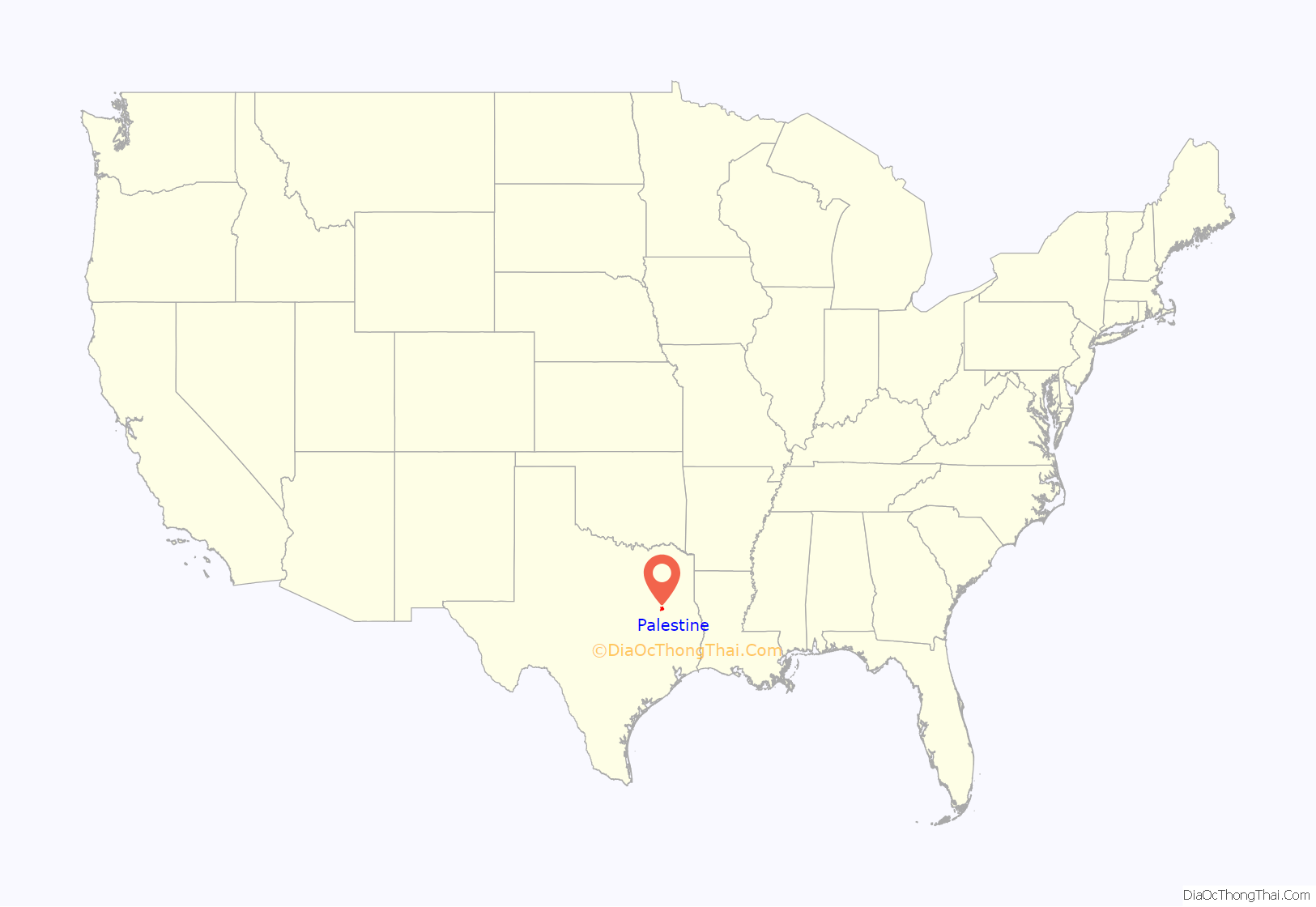
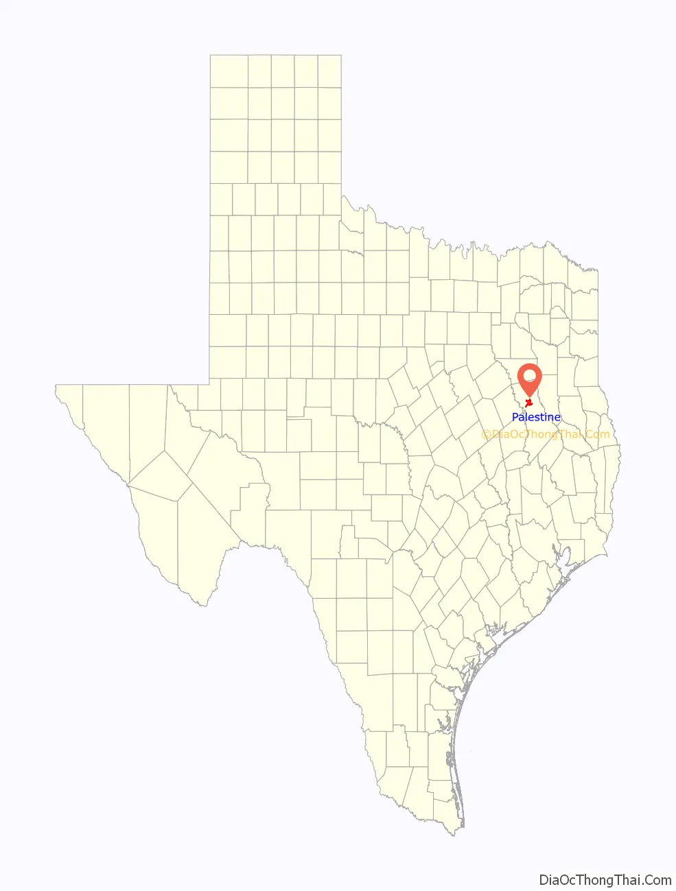
Palestine location map. Where is Palestine city?
History
Indigenous groups such as the Coushatta Tribe occupied this area for thousands of years before European encounter. During the years of Spanish and Mexican control of major parts of the Southwest, what became East Texas was lightly settled by Europeans.
Founding
A trading post was established by Anglo Americans here about 1843, and some settlers gathered around it. In 1846, the Texas Legislature created Palestine to serve as a seat for the newly established Anderson County. James R. Fulton, Johnston Shelton, and William Bigelow were hired by the first Anderson County commissioners to survey the surrounding land and lay out a town site. This consisted of a central courthouse square and the surrounding 24 blocks.
The city was named after Palestine, Illinois, as suggested by Micham Main and or Daniel Parker, a minister of Pilgrim Church who had migrated with the Main family and numerous other settlers from that town.
By 1858, Palestine had grown to a population of 2000. An 1861 state almanac showed that the city was connected to the rest of Texas via a tri-weekly stagecoach that served Huntsville, Crockett, and Nacogdoches. In 1861 a joint resolution called for the construction of the “Metropolitan Railroad” from Texarkana to Austin, passing through Palestine, Henderson, and Fairfield. These plans were interrupted when the American Civil War broke out.
In the postwar period, during the Reconstruction era, the timber trade and town growth were stimulated in the 1870s by the construction of a railroad through here. The city had a population of more than 10,000 by 1898.
Railroad
The International Railroad and the Houston and Great Northern Railroad first connected Palestine to the city of Hearne in 1872. Later that year it was connected northeast to Longview. The railroad merged in 1873 to become the International and Great Northern Railroad (IGN).
The IGN later became part of the Missouri Pacific Railroad, then ultimately Union Pacific Railroad. In 1875, IGN president H.M. Hoxie moved to Palestine and built the first Victorian mansion there. Successful merchant owners and railroad executives built other elaborate homes along South Sycamore Street.
The IGN built a major depot in 1892 and a modern passenger coach shop in 1902, making Palestine an important locomotive and coach location. These shops continued to operate until 1954. At that time, the present facility was built, which is exclusively for freight-car repair.
Today, the Palestine Car Shop is one of only two car shops on the Union Pacific Railroad that perform major modifications and repairs to freight cars. The Palestine UP workforce has more than 100 employees.
After the state completed the Rusk Penitentiary near the city of Rusk, the state leased convict labor to the railroad as workers. The railroad originally transported raw materials to the iron smelter located at the Rusk Penitentiary. In 1906, the line reached Maydelle, and by 1909, the line was completed when it reached Palestine.
Regularly scheduled train service ceased in 1921. The line was leased to various railroad companies until 1969, when they abandoned it during national restructuring of the industry. The Texas Legislature adapted the railroad as a state park in 1972, to be devoted to operating trains that showed some of the state’s railroad history.
The Texas State Railroad is a state park that allows visitors to ride trains pulled by diesel and steam locomotives between the park’s Victorian-style depots and through the forests of East Texas. This short railroad line dates to 1883.
Modern era
In 1914, the county’s fifth courthouse was completed. It is still in use. One of the many historical sites is Sacred Heart Catholic Church, which was designed by Nicholas J. Clayton.
In 1928, oil was discovered at Boggy Creek, east of Palestine. The production of oil resources added to and diversified the town’s economy. Palestine became a center for oil-well servicing and supplies in support of other producing fields found later elsewhere in Anderson County.
Construction of the earth-filled Blackburn Crossing Dam on the Upper Neches River, creating Lake Palestine as a reliable source of water, was begun in 1960, and completed in 1962. A municipal water authority manages this resource. The dam was enlarged from 1969 to 1972 to 75 feet high, and 5,720 feet long.
About 40% of the content from the 2003 Space Shuttle Columbia disaster was recovered. seven astronauts were killed in the accident. Debris from Columbia was found in and outside Palestine and other East Texas towns. Palestine’s NASA Columbia Scientific Balloon Facility (renamed in honor of the shuttle crew), has flown 1,700 high-altitude balloons for universities and research agencies.
On November 15, 2015, a mass shooting took place at a campsite several miles northwest of Palestine. Six people were killed by an intoxicated neighbor who was upset about losing his family’s land. The shooter was charged with capital murder. He was convicted and sentenced to death by a Brazos County jury on November 15, 2017.
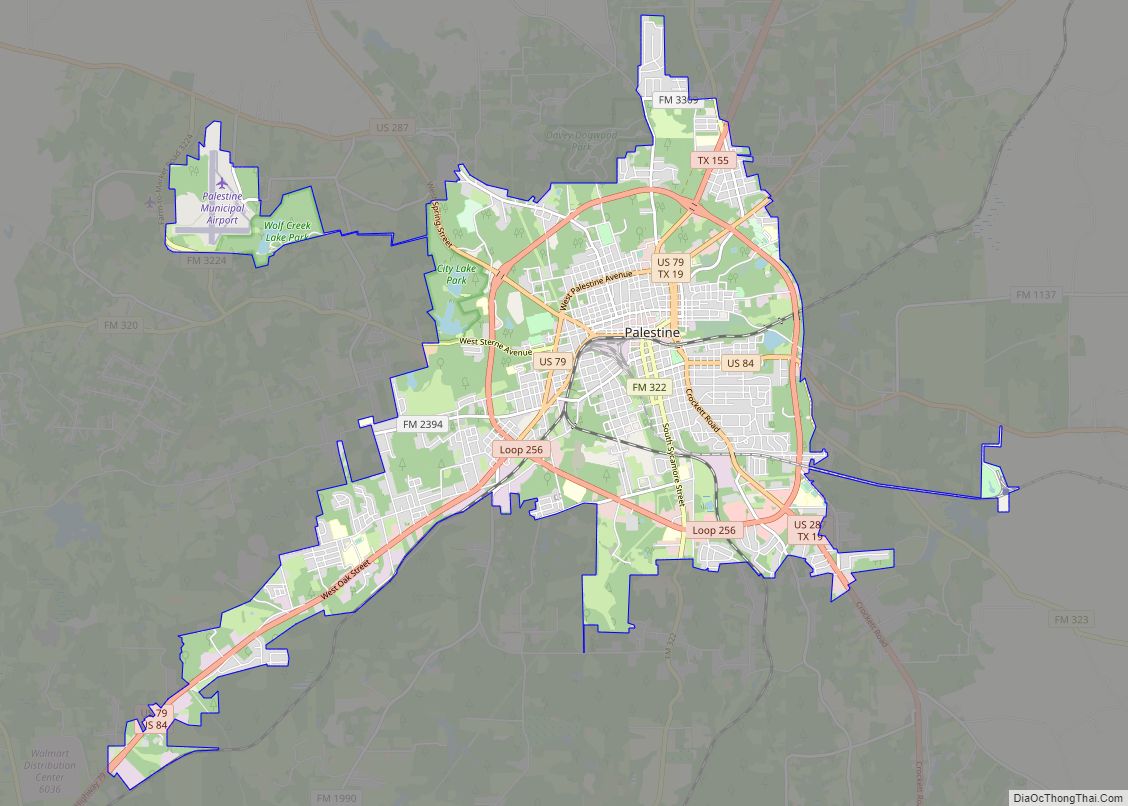
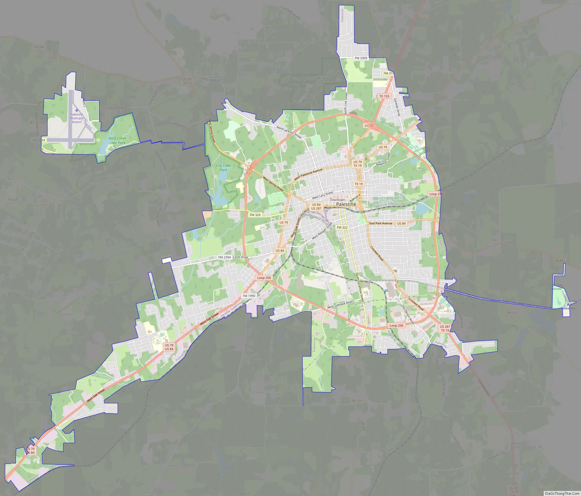
Palestine Road Map
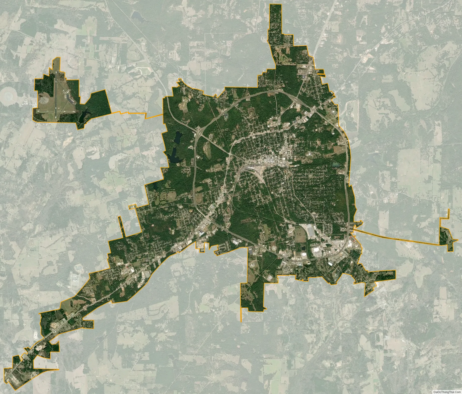
Palestine city Satellite Map
Geography
Palestine is located near the center of Anderson County at 31°45′29″N 95°38′19″W / 31.75806°N 95.63861°W / 31.75806; -95.63861 (31.757925, –95.638473). Several numbered highways converge on the city, including U.S. Highways 79, 84, and 287, plus Texas State highways 19 and 155. Dallas is 110 miles (180 km) to the northwest, and Houston is 150 miles (240 km) to the south. Tyler is 47 miles (76 km) to the northeast.
According to the United States Census Bureau, the city has a total area of 19.6 square miles (50.7 km), of which 19.4 square miles (50.2 km) are land and 0.19 square miles (0.5 km), or 1.06%, is covered by water.
Lake Palestine
Lake Palestine is a freshwater lake created in 1962 by the construction of the Blackburn Crossing dam on the Neches River. A 25,600-acre lake with a total length of 18 miles, 135 miles of shoreline and an average depth of 16.25 ft, it offers an array of freshwater fish species including bass, crappie, and catfish. The Upper Neches River Municipal Water Authority owns and operates Lake Palestine.
The city of Palestine has a water contract for 25 million gallons of water per day. It is served by a channel dam, 13 miles of pipeline, and a water treatment plant which the city operates for water coming into the city.
Climate
The average warmest month is July; the highest recorded temperature was 114 °F in 1954. On average, the coolest month is January, and the lowest recorded temperature was –6 °F in 2021. The maximum average precipitation occurs in October.
See also
Map of Texas State and its subdivision:- Anderson
- Andrews
- Angelina
- Aransas
- Archer
- Armstrong
- Atascosa
- Austin
- Bailey
- Bandera
- Bastrop
- Baylor
- Bee
- Bell
- Bexar
- Blanco
- Borden
- Bosque
- Bowie
- Brazoria
- Brazos
- Brewster
- Briscoe
- Brooks
- Brown
- Burleson
- Burnet
- Caldwell
- Calhoun
- Callahan
- Cameron
- Camp
- Carson
- Cass
- Castro
- Chambers
- Cherokee
- Childress
- Clay
- Cochran
- Coke
- Coleman
- Collin
- Collingsworth
- Colorado
- Comal
- Comanche
- Concho
- Cooke
- Coryell
- Cottle
- Crane
- Crockett
- Crosby
- Culberson
- Dallam
- Dallas
- Dawson
- Deaf Smith
- Delta
- Denton
- Dewitt
- Dickens
- Dimmit
- Donley
- Duval
- Eastland
- Ector
- Edwards
- El Paso
- Ellis
- Erath
- Falls
- Fannin
- Fayette
- Fisher
- Floyd
- Foard
- Fort Bend
- Franklin
- Freestone
- Frio
- Gaines
- Galveston
- Garza
- Gillespie
- Glasscock
- Goliad
- Gonzales
- Gray
- Grayson
- Gregg
- Grimes
- Guadalupe
- Hale
- Hall
- Hamilton
- Hansford
- Hardeman
- Hardin
- Harris
- Harrison
- Hartley
- Haskell
- Hays
- Hemphill
- Henderson
- Hidalgo
- Hill
- Hockley
- Hood
- Hopkins
- Houston
- Howard
- Hudspeth
- Hunt
- Hutchinson
- Irion
- Jack
- Jackson
- Jasper
- Jeff Davis
- Jefferson
- Jim Hogg
- Jim Wells
- Johnson
- Jones
- Karnes
- Kaufman
- Kendall
- Kenedy
- Kent
- Kerr
- Kimble
- King
- Kinney
- Kleberg
- Knox
- La Salle
- Lamar
- Lamb
- Lampasas
- Lavaca
- Lee
- Leon
- Liberty
- Limestone
- Lipscomb
- Live Oak
- Llano
- Loving
- Lubbock
- Lynn
- Madison
- Marion
- Martin
- Mason
- Matagorda
- Maverick
- McCulloch
- McLennan
- McMullen
- Medina
- Menard
- Midland
- Milam
- Mills
- Mitchell
- Montague
- Montgomery
- Moore
- Morris
- Motley
- Nacogdoches
- Navarro
- Newton
- Nolan
- Nueces
- Ochiltree
- Oldham
- Orange
- Palo Pinto
- Panola
- Parker
- Parmer
- Pecos
- Polk
- Potter
- Presidio
- Rains
- Randall
- Reagan
- Real
- Red River
- Reeves
- Refugio
- Roberts
- Robertson
- Rockwall
- Runnels
- Rusk
- Sabine
- San Augustine
- San Jacinto
- San Patricio
- San Saba
- Schleicher
- Scurry
- Shackelford
- Shelby
- Sherman
- Smith
- Somervell
- Starr
- Stephens
- Sterling
- Stonewall
- Sutton
- Swisher
- Tarrant
- Taylor
- Terrell
- Terry
- Throckmorton
- Titus
- Tom Green
- Travis
- Trinity
- Tyler
- Upshur
- Upton
- Uvalde
- Val Verde
- Van Zandt
- Victoria
- Walker
- Waller
- Ward
- Washington
- Webb
- Wharton
- Wheeler
- Wichita
- Wilbarger
- Willacy
- Williamson
- Wilson
- Winkler
- Wise
- Wood
- Yoakum
- Young
- Zapata
- Zavala
- Alabama
- Alaska
- Arizona
- Arkansas
- California
- Colorado
- Connecticut
- Delaware
- District of Columbia
- Florida
- Georgia
- Hawaii
- Idaho
- Illinois
- Indiana
- Iowa
- Kansas
- Kentucky
- Louisiana
- Maine
- Maryland
- Massachusetts
- Michigan
- Minnesota
- Mississippi
- Missouri
- Montana
- Nebraska
- Nevada
- New Hampshire
- New Jersey
- New Mexico
- New York
- North Carolina
- North Dakota
- Ohio
- Oklahoma
- Oregon
- Pennsylvania
- Rhode Island
- South Carolina
- South Dakota
- Tennessee
- Texas
- Utah
- Vermont
- Virginia
- Washington
- West Virginia
- Wisconsin
- Wyoming