Map of Rotan city
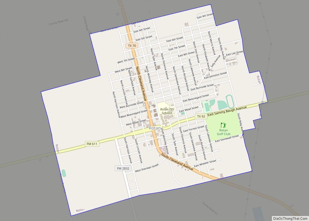
Rotan is a city in Fisher County, Texas, United States. The population was 1,508 at the 2010 census, down from 1,611 at the 2000 census. Rotan city overview: Name: Rotan city LSAD Code: 25 LSAD Description: city (suffix) State: Texas County: Fisher County Elevation: 1,949 ft (594 m) Total Area: 2.02 sq mi (5.24 km²) Land Area: 2.02 sq mi (5.24 km²) Water ... Read more
Map of Rotan city
Map of Rosser village
Rosser is a village in Kaufman County, Texas, United States. The population was 332 at the 2010 census. Rosser village overview: Name: Rosser village LSAD Code: 47 LSAD Description: village (suffix) State: Texas County: Kaufman County Elevation: 361 ft (110 m) Total Area: 1.94 sq mi (5.03 km²) Land Area: 1.91 sq mi (4.95 km²) Water Area: 0.03 sq mi (0.08 km²) Total Population: 332 Population ... Read more
Map of Rosser village
Map of Ross city, Texas
Ross is a rural city in McLennan County, Texas, United States. The population was 234 at the 2010 census. It is part of the Waco Metropolitan Statistical Area. Ross city overview: Name: Ross city LSAD Code: 25 LSAD Description: city (suffix) State: Texas County: McLennan County Elevation: 571 ft (174 m) Total Area: 1.75 sq mi (4.53 km²) Land Area: ... Read more
Map of Ross city, Texas
Map of Rosita CDP
Rosita, formerly known as Rosita South, is a census-designated place (CDP) in Maverick County, Texas, United States. The population was 2,704 as of the 2010 census. The Kickapoo Indian Reservation of Texas is located within the community. Rosita CDP overview: Name: Rosita CDP LSAD Code: 57 LSAD Description: CDP (suffix) State: Texas County: Maverick County ... Read more
Map of Rosita CDP
Map of Rule town
Rule is a town in Haskell County, Texas, United States. The population was 636 at the 2010 census, down from 698 at the 2000 census. The community was named for W. A. Rule, a railroad man. Rule town overview: Name: Rule town LSAD Code: 43 LSAD Description: town (suffix) State: Texas County: Haskell County Elevation: ... Read more
Map of Rule town
Map of Royse City
Royse City is a city in Rockwall County in the U.S. state of Texas. It also extends into Collin and Hunt counties. The population was 2,957 at the 2000 census, rising to 9,349 in 2010. The estimated population in 2018 was 12,998. In 2020, its population grew to 13,508. Royse City city overview: Name: Royse ... Read more
Map of Royse City
Map of Roxton city
Roxton is a city in Lamar County, Texas, United States. As of the 2010 census, the city population was 650 and 548 in 2020. Roxton city overview: Name: Roxton city LSAD Code: 25 LSAD Description: city (suffix) State: Texas County: Lamar County Elevation: 512 ft (156 m) Total Area: 0.87 sq mi (2.26 km²) Land Area: 0.86 sq mi (2.24 km²) Water Area: ... Read more
Map of Roxton city
Map of Rowlett city
Rowlett (/raʊˈlɛt/, traditionally /ˈraʊlɪt/) is a city in Dallas and Rockwall counties in the U.S. state of Texas, and an eastern suburb of Dallas. The total population estimate is 73,270 in 2021. It is a growing, upscale community with nearly $1.5 billion in development in the Dallas–Fort Worth metroplex, located on Lake Ray Hubbard. Rowlett ... Read more
Map of Rowlett city
Map of Round Top town
Round Top is a town in Fayette County, Texas, United States. The population was 90 at the 2010 census. Round Top town overview: Name: Round Top town LSAD Code: 43 LSAD Description: town (suffix) State: Texas County: Fayette County Elevation: 440 ft (134 m) Total Area: 0.95 sq mi (2.47 km²) Land Area: 0.95 sq mi (2.47 km²) Water Area: 0.00 sq mi (0.00 km²) Total ... Read more
Map of Round Top town
Map of Round Mountain town, Texas
Round Mountain is a town in Blanco County, Texas, United States. The population was 181 at the 2010 census. Round Mountain town overview: Name: Round Mountain town LSAD Code: 43 LSAD Description: town (suffix) State: Texas County: Blanco County Elevation: 1,280 ft (390 m) Total Area: 2.30 sq mi (5.97 km²) Land Area: 2.30 sq mi (5.97 km²) Water Area: 0.00 sq mi (0.00 km²) Total ... Read more
Map of Round Mountain town, Texas
Map of Salineño CDP
Salineño is a census-designated place (CDP) in Starr County, Texas, United States. The name was changed in 2008, adding a tilde over the second n. The population was 176 at the 2020 census, down from 201 at the 2010 census. Salineño CDP overview: Name: Salineño CDP LSAD Code: 57 LSAD Description: CDP (suffix) State: Texas ... Read more
Map of Salineño CDP
Map of Salineño North CDP
Salineño North is a census-designated place (CDP) in Starr County, Texas, United States. This was a new CDP for the 2010 census with a population of 115. Salineño North CDP overview: Name: Salineño North CDP LSAD Code: 57 LSAD Description: CDP (suffix) State: Texas County: Starr County Total Area: 0.2 sq mi (0.5 km²) Land Area: 0.2 sq mi (0.5 km²) ... Read more
Map of Salineño North CDP