Rowlett (/raʊˈlɛt/, traditionally /ˈraʊlɪt/) is a city in Dallas and Rockwall counties in the U.S. state of Texas, and an eastern suburb of Dallas. The total population estimate is 73,270 in 2021. It is a growing, upscale community with nearly $1.5 billion in development in the Dallas–Fort Worth metroplex, located on Lake Ray Hubbard.
| Name: | Rowlett city |
|---|---|
| LSAD Code: | 25 |
| LSAD Description: | city (suffix) |
| State: | Texas |
| County: | Dallas County, Rockwall County |
| Elevation: | 505 ft (154 m) |
| Total Area: | 20.82 sq mi (53.91 km²) |
| Land Area: | 20.75 sq mi (53.73 km²) |
| Water Area: | 0.07 sq mi (0.18 km²) |
| Total Population: | 62,535 |
| Population Density: | 3,246.04/sq mi (1,253.33/km²) |
| FIPS code: | 4863572 |
| GNISfeature ID: | 1345719 |
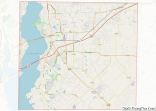
Online Interactive Map
Click on ![]() to view map in "full screen" mode.
to view map in "full screen" mode.
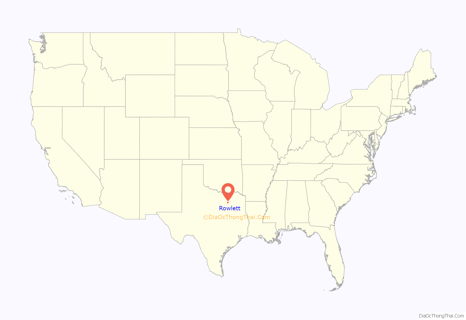
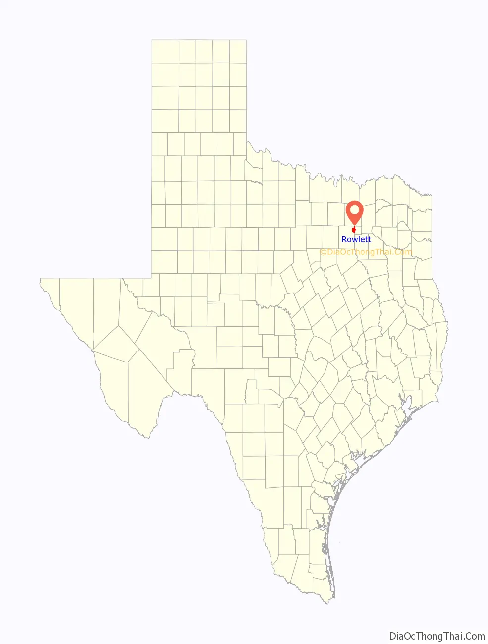
Rowlett location map. Where is Rowlett city?
History
Rowlett derives its name from Rowlett Creek, which flows into Lake Ray Hubbard and is a major tributary of the east fork of the Trinity River. The creek in turn was named for a waterway running through the property of Daniel Rowlett who moved from Kentucky to Bonham, Texas, in 1835. Daniel, who was a member of the Smoot-Rowlett political family, had no direct dealings with the town that now bears his name.
The first post office opened on April 5, 1880, and it was called “Morris” after Postmaster Austin Morris.
The town was later renamed “Rowlett”. The Dallas and Greenville Railway passed through the town in 1886, connecting Dallas with Greenville, Texas, and the Missouri–Kansas–Texas Railroad. Shortly after its opening, the line was formally sold to the MKT.
In 1921 the town was a stop on the Bankhead Highway.
The town incorporated in 1952 when its population was 250. In the 1960s the town languished as Interstate 30 bypassed Rowlett.
The town has had a building boom since the completion of Lake Ray Hubbard in 1971 – growing to 1,600 by 1973; 10,573 by 1989; 23,260 by 1990; and 44,503 by 2000.
Rowlett gained international notoriety in 1996 when local resident Darlie Routier was convicted of murdering her children as they slept.
In 2003 the town made an unsuccessful formal proposal to get the Dallas Cowboys to move to a 1,000-acre (4.0 km) “5-Point Park” on the banks of Lake Ray Hubbard when the lease for Texas Stadium expires.
In 2013 the Rowlett City Council was challenged by the Freedom From Religion Foundation and Metroplex Atheists regarding opening prayer invocations at city hall meetings. In a court case in May 2014 the U.S. Supreme Court reaffirmed a previous court ruling (Marsh v. Chambers) upholding the tradition of opening legislative sessions with sectarian prayer and additionally ruled in favor of a town’s right to have invocations given by the predominant religion within its borders as long as it did not discriminate or coerce participation. (Town of Greece v. Galloway) Atheist proponents then asked the Rowlett City Council to be included in giving invocations. They were denied based on the Supreme Court ruling and city policy stating the invocation should be given by members of the community’s locally established religious congregations.”
On the evening of December 26, 2015 a violent storm produced a deadly EF4 tornado that tore a 13-mile path from the neighboring city of Garland, Texas, through the southeast portion of Rowlett, severely damaging or destroying hundreds of homes and vehicles along with several businesses and a city water tower.
On February 8, 2017, the historic water tower on Martha Lane built in 1980 was demolished two years after it suffered damage from the EF4 tornado on December 26, 2015.
According to the U.S. Census Bureau, the City of Rowlett is rated number 8 of the fastest growing cities in the United States with 5.1% growth from July 2017 to July 2018.
In 2019, the City of Rowlett gained regional recognition when Sapphire Bay Development, LLC and the City published plans to construct a master planned community in the middle of the Dallas/Fort Worth Metroplex. The 116-acre development will be Texas’ first resort destination anchored by a man-made lagoon, offering guests a luxurious stay along its shore at the 500 room Sapphire Bay Resort, operated and managed by Destination Hotels by Hyatt. The project will also feature a surf village and a water park, 1,500+ residential units, 1.7 million square feet of mixed-use restaurant, retail, entertainment, office and hospitality space, 20+ acres of parks and trails, a 1,000 slip marina.
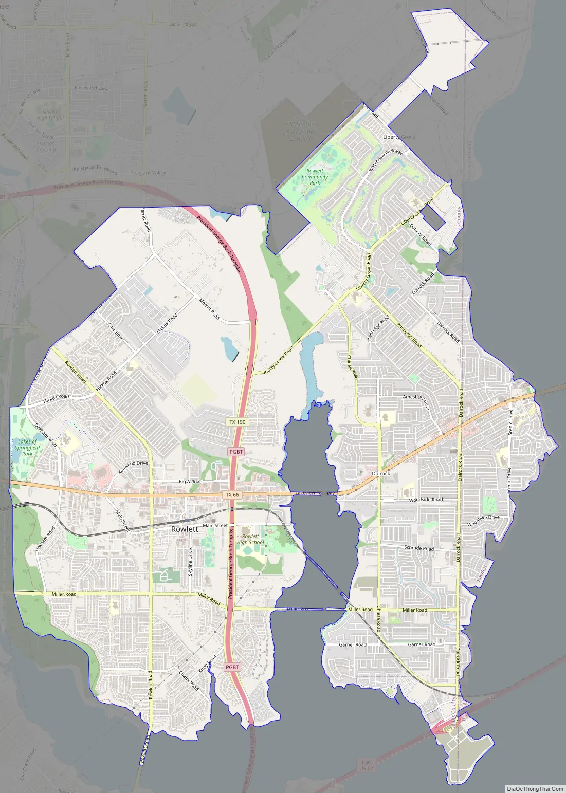
Rowlett Road Map
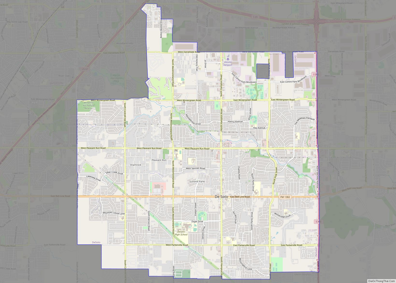
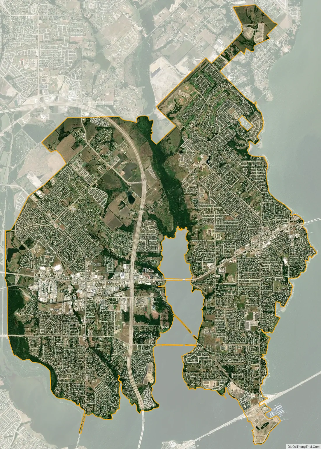
Rowlett city Satellite Map
Geography
Rowlett is located at 32°54′25″N 96°32′51″W / 32.90694°N 96.54750°W / 32.90694; -96.54750 (32.907020, –96.547415).
According to the United States Census Bureau, the city has a total area of 20.0 square miles (51.7 km), of which 19.9 square miles (51.5 km) is land and 0.08 square miles (0.2 km), or 0.34%, is water.
See also
Map of Texas State and its subdivision:- Anderson
- Andrews
- Angelina
- Aransas
- Archer
- Armstrong
- Atascosa
- Austin
- Bailey
- Bandera
- Bastrop
- Baylor
- Bee
- Bell
- Bexar
- Blanco
- Borden
- Bosque
- Bowie
- Brazoria
- Brazos
- Brewster
- Briscoe
- Brooks
- Brown
- Burleson
- Burnet
- Caldwell
- Calhoun
- Callahan
- Cameron
- Camp
- Carson
- Cass
- Castro
- Chambers
- Cherokee
- Childress
- Clay
- Cochran
- Coke
- Coleman
- Collin
- Collingsworth
- Colorado
- Comal
- Comanche
- Concho
- Cooke
- Coryell
- Cottle
- Crane
- Crockett
- Crosby
- Culberson
- Dallam
- Dallas
- Dawson
- Deaf Smith
- Delta
- Denton
- Dewitt
- Dickens
- Dimmit
- Donley
- Duval
- Eastland
- Ector
- Edwards
- El Paso
- Ellis
- Erath
- Falls
- Fannin
- Fayette
- Fisher
- Floyd
- Foard
- Fort Bend
- Franklin
- Freestone
- Frio
- Gaines
- Galveston
- Garza
- Gillespie
- Glasscock
- Goliad
- Gonzales
- Gray
- Grayson
- Gregg
- Grimes
- Guadalupe
- Hale
- Hall
- Hamilton
- Hansford
- Hardeman
- Hardin
- Harris
- Harrison
- Hartley
- Haskell
- Hays
- Hemphill
- Henderson
- Hidalgo
- Hill
- Hockley
- Hood
- Hopkins
- Houston
- Howard
- Hudspeth
- Hunt
- Hutchinson
- Irion
- Jack
- Jackson
- Jasper
- Jeff Davis
- Jefferson
- Jim Hogg
- Jim Wells
- Johnson
- Jones
- Karnes
- Kaufman
- Kendall
- Kenedy
- Kent
- Kerr
- Kimble
- King
- Kinney
- Kleberg
- Knox
- La Salle
- Lamar
- Lamb
- Lampasas
- Lavaca
- Lee
- Leon
- Liberty
- Limestone
- Lipscomb
- Live Oak
- Llano
- Loving
- Lubbock
- Lynn
- Madison
- Marion
- Martin
- Mason
- Matagorda
- Maverick
- McCulloch
- McLennan
- McMullen
- Medina
- Menard
- Midland
- Milam
- Mills
- Mitchell
- Montague
- Montgomery
- Moore
- Morris
- Motley
- Nacogdoches
- Navarro
- Newton
- Nolan
- Nueces
- Ochiltree
- Oldham
- Orange
- Palo Pinto
- Panola
- Parker
- Parmer
- Pecos
- Polk
- Potter
- Presidio
- Rains
- Randall
- Reagan
- Real
- Red River
- Reeves
- Refugio
- Roberts
- Robertson
- Rockwall
- Runnels
- Rusk
- Sabine
- San Augustine
- San Jacinto
- San Patricio
- San Saba
- Schleicher
- Scurry
- Shackelford
- Shelby
- Sherman
- Smith
- Somervell
- Starr
- Stephens
- Sterling
- Stonewall
- Sutton
- Swisher
- Tarrant
- Taylor
- Terrell
- Terry
- Throckmorton
- Titus
- Tom Green
- Travis
- Trinity
- Tyler
- Upshur
- Upton
- Uvalde
- Val Verde
- Van Zandt
- Victoria
- Walker
- Waller
- Ward
- Washington
- Webb
- Wharton
- Wheeler
- Wichita
- Wilbarger
- Willacy
- Williamson
- Wilson
- Winkler
- Wise
- Wood
- Yoakum
- Young
- Zapata
- Zavala
- Alabama
- Alaska
- Arizona
- Arkansas
- California
- Colorado
- Connecticut
- Delaware
- District of Columbia
- Florida
- Georgia
- Hawaii
- Idaho
- Illinois
- Indiana
- Iowa
- Kansas
- Kentucky
- Louisiana
- Maine
- Maryland
- Massachusetts
- Michigan
- Minnesota
- Mississippi
- Missouri
- Montana
- Nebraska
- Nevada
- New Hampshire
- New Jersey
- New Mexico
- New York
- North Carolina
- North Dakota
- Ohio
- Oklahoma
- Oregon
- Pennsylvania
- Rhode Island
- South Carolina
- South Dakota
- Tennessee
- Texas
- Utah
- Vermont
- Virginia
- Washington
- West Virginia
- Wisconsin
- Wyoming