Map of Stanton city, Texas
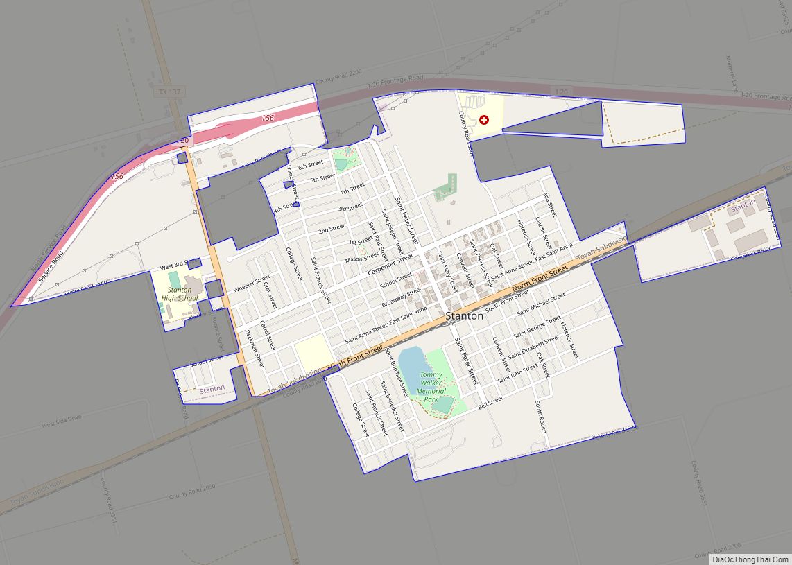
Stanton is a city in and the county seat of Martin County, Texas, United States. Stanton was founded as Marienfeld by German immigrants that were some of the first settlers in this region of Texas. The population was 2,492 at the 2010 census. Stanton city overview: Name: Stanton city LSAD Code: 25 LSAD Description: city ... Read more
Map of Stanton city, Texas
Map of Stamford city, Texas
Stamford is a city on the border of Jones and Haskell Counties in west-central Texas. The population was 3,124 at the 2010 census, down from 3,636 at the 2000 census. Henry McHarg, president of the Texas Central Railroad, named the site in 1900 for his hometown of Stamford, Connecticut. The city is home to the ... Read more
Map of Stamford city, Texas
Map of Stagecoach town, Texas
Stagecoach is a town in Montgomery County, Texas, United States. The population was 538 at the 2010 census. Stagecoach town overview: Name: Stagecoach town LSAD Code: 43 LSAD Description: town (suffix) State: Texas County: Montgomery County Elevation: 194 ft (59 m) Total Area: 1.18 sq mi (3.05 km²) Land Area: 1.15 sq mi (2.98 km²) Water Area: 0.03 sq mi (0.07 km²) Total Population: 538 Population ... Read more
Map of Stagecoach town, Texas
Map of Stonewall CDP, Texas
Stonewall is an unincorporated community and census-designated place (CDP) in Gillespie County, Texas, United States. The population was 525 at the 2010 census. It was named for Confederate General Thomas J. (Stonewall) Jackson, by Israel P. Nunez who established a stage station near the site in 1870. Stonewall CDP overview: Name: Stonewall CDP LSAD Code: ... Read more
Map of Stonewall CDP, Texas
Map of Sundown city, Texas
Sundown is a small town in Hockley County, Texas, United States. The community school district is Sundown ISD. The population was 1,397 at the 2010 census, a decrease from 1,505 at the 2000 census. Sundown city overview: Name: Sundown city LSAD Code: 25 LSAD Description: city (suffix) State: Texas County: Hockley County Elevation: 3,540 ft (1,079 m) ... Read more
Map of Sundown city, Texas
Map of Sun Valley city, Texas
Sun Valley is a small city in Lamar County, Texas, United States. The population was 69 at the 2010 census, up from 51 at the 2000 census; in 2020, its population was 70. Sun Valley city overview: Name: Sun Valley city LSAD Code: 25 LSAD Description: city (suffix) State: Texas County: Lamar County Elevation: 535 ft ... Read more
Map of Sun Valley city, Texas
Map of Sulphur Springs city, Texas
Sulphur Springs is a city in and the county seat of Hopkins County, Texas, United States. As of the 2010 census, its population was 15,449. Sulphur Springs is located along the western edge of Northeast Texas. Sulphur Springs city overview: Name: Sulphur Springs city LSAD Code: 25 LSAD Description: city (suffix) State: Texas County: Hopkins ... Read more
Map of Sulphur Springs city, Texas
Map of Sullivan City
Sullivan City is a city in Hidalgo County, Texas. The population was 4,002 at the 2010 United States Census. It is part of the McAllen–Edinburg–Mission and Reynosa–McAllen metropolitan areas. Sullivan City city overview: Name: Sullivan City city LSAD Code: 25 LSAD Description: city (suffix) State: Texas County: Hidalgo County Elevation: 200 ft (61 m) Total Area: 3.59 sq mi ... Read more
Map of Sullivan City
Map of Sudan city
Sudan is a city in Lamb County in Texas, United States. Its population was 958 at the 2010 census. Sudan city overview: Name: Sudan city LSAD Code: 25 LSAD Description: city (suffix) State: Texas County: Lamb County Elevation: 3,757 ft (1,145 m) Total Area: 1.02 sq mi (2.65 km²) Land Area: 1.02 sq mi (2.65 km²) Water Area: 0.00 sq mi (0.00 km²) Total Population: 958 ... Read more
Map of Sudan city
Map of Study Butte CDP
Study Butte (/ˈstjuːdi ˌbjuːt/ STEW-dee BEWT) is a census-designated place (CDP) in Brewster County, Texas, United States. The population was 233 at the 2010 census. At the 2000 census, the area was part of the Study Butte-Terlingua CDP. Study Butte CDP overview: Name: Study Butte CDP LSAD Code: 57 LSAD Description: CDP (suffix) State: Texas ... Read more
Map of Study Butte CDP
Map of Streetman town
Streetman is a town in Freestone and Navarro counties in Texas, United States. As of the 2010 census the population was 247, up from 203 at the 2000 census. Streetman town overview: Name: Streetman town LSAD Code: 43 LSAD Description: town (suffix) State: Texas County: Freestone County, Navarro County Elevation: 371 ft (113 m) Total Area: 1.41 sq mi ... Read more
Map of Streetman town
Map of Strawn city, Texas
Strawn is a city in Palo Pinto County, Texas, United States. The population was 653 at the 2010 census. Strawn, on State highways 16 and 108, Farm Road 2372, and the Missouri Pacific Railroad in southwestern Palo Pinto County, was one of several towns developed about 1880 when the Texas and Pacific Railway began service. ... Read more
Map of Strawn city, Texas