Map of Westminster CDP, Texas
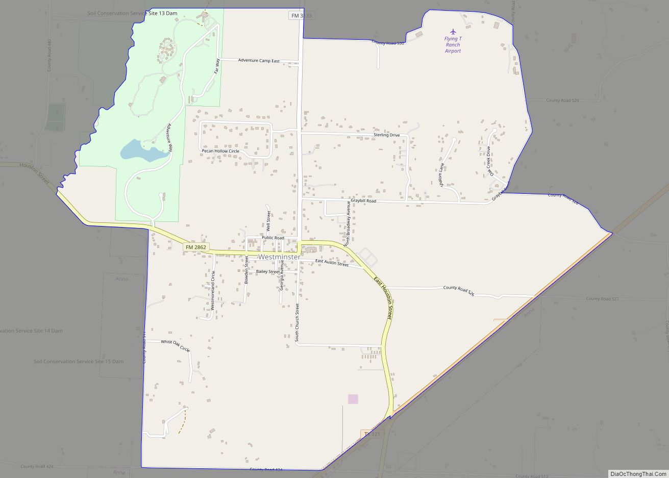
Westminster (/wɛstˈmɪnstər/) is an unincorporated community and census-designated place (CDP) in northeastern Collin County, Texas, United States. The population was 861 as of the 2010 census, up from 390 at the 2000 census, at which time it was a city. Westminster is located at the intersection of FM 3133 and FM 2862, northeast of McKinney, ... Read more
Map of Westminster CDP, Texas
Map of Westlake town, Texas
Westlake is a town in Denton and Tarrant counties in the U.S. state of Texas and a suburb of the Dallas-Fort Worth metroplex. The population is 1,900 as of the 2020 United States census. Westlake town overview: Name: Westlake town LSAD Code: 43 LSAD Description: town (suffix) State: Texas County: Denton County, Tarrant County Incorporated: ... Read more
Map of Westlake town, Texas
Map of Western Lake CDP
Western Lake is a census-designated place in Parker County, Texas, United States. This was a new CDP for the 2010 census with a population of 1,525. Western Lake CDP overview: Name: Western Lake CDP LSAD Code: 57 LSAD Description: CDP (suffix) State: Texas County: Parker County Elevation: 807 ft (246 m) Total Area: 3.52 sq mi (9.1 km²) Land Area: ... Read more
Map of Western Lake CDP
Map of Westdale CDP
Westdale is a census-designated place (CDP) in Jim Wells County, Texas, United States. The population was 372 at the 2010 census, up from 295 at the 2000 census. Westdale CDP overview: Name: Westdale CDP LSAD Code: 57 LSAD Description: CDP (suffix) State: Texas County: Jim Wells County Elevation: 213 ft (65 m) Total Area: 4.03 sq mi (10.43 km²) Land ... Read more
Map of Westdale CDP
Map of Westbrook city, Texas
Westbrook is a city in Mitchell County, Texas, United States. The population was 203 at the 2000 census. Westbrook city overview: Name: Westbrook city LSAD Code: 25 LSAD Description: city (suffix) State: Texas County: Mitchell County Elevation: 2,162 ft (659 m) Total Area: 0.42 sq mi (1.09 km²) Land Area: 0.42 sq mi (1.09 km²) Water Area: 0.00 sq mi (0.00 km²) Total Population: 253 Population ... Read more
Map of Westbrook city, Texas
Map of West city, Texas
West is a city in McLennan County, Texas, United States. As of the 2020 census, the city population was 2,531. It is named after Thomas West, the first postmaster of the city. The city is located in the north-central part of Texas, approximately 70 miles (110 km) south of the Dallas-Fort Worth Metroplex, 20 miles north ... Read more
Map of West city, Texas
Map of West University Place city
West University Place, often called West University or West U for short, is a city located in the U.S. state of Texas within the Houston–Sugar Land metropolitan area and southwestern Harris County. At the 2020 U.S. census, the population of the city was 14,955. It is nicknamed “The Neighborhood City” and is mainly a bedroom ... Read more
Map of West University Place city
Map of West Tawakoni city
West Tawakoni (/təˈwɑːkəni/ tə-WAH-kə-nee) is a city in Hunt County, Texas, United States. The population was 1,895 at the 2020 census. West Tawakoni is located on the west side of Lake Tawakoni, while its twin city East Tawakoni is located on the east side of the lake in Rains County. West Tawakoni city overview: Name: ... Read more
Map of West Tawakoni city
Map of Wheeler city, Texas
Wheeler is a city, and the county seat of Wheeler County, Texas, United States, located on the eastern border of the Texas Panhandle. The population was last reported at 1,592 in the 2010 census. Wheeler city overview: Name: Wheeler city LSAD Code: 25 LSAD Description: city (suffix) State: Texas County: Wheeler County Elevation: 2,507 ft (764 m) ... Read more
Map of Wheeler city, Texas
Map of Wharton city, Texas
Wharton is a city in and the county seat of Wharton County, Texas, United States. This city is 60 mi (97 km) southwest of Houston. Its population was 8,832 at the 2010 census and 8,627 at the 2020 census. Wharton is located on the Colorado River of Texas. U.S. Highway 59 passes west of it. Wharton city ... Read more
Map of Wharton city, Texas
Map of Westworth Village city
Westworth Village is a city in Tarrant County, Texas, United States. The population was 2,472 at the 2010 census. Westworth Village city overview: Name: Westworth Village city LSAD Code: 25 LSAD Description: city (suffix) State: Texas County: Tarrant County Elevation: 568 ft (173 m) Total Area: 2.08 sq mi (5.40 km²) Land Area: 2.07 sq mi (5.37 km²) Water Area: 0.01 sq mi (0.03 km²) Total ... Read more
Map of Westworth Village city
Map of Westwood Shores CDP
Westwood Shores is a census-designated place (CDP) in Trinity County, Texas, United States. This was a new CDP for the 2010 census with a population of 1,162, increasing to 1,239 at the 2020 census. Westwood Shores CDP overview: Name: Westwood Shores CDP LSAD Code: 57 LSAD Description: CDP (suffix) State: Texas County: Trinity County Total ... Read more
Map of Westwood Shores CDP