Map of Westway CDP
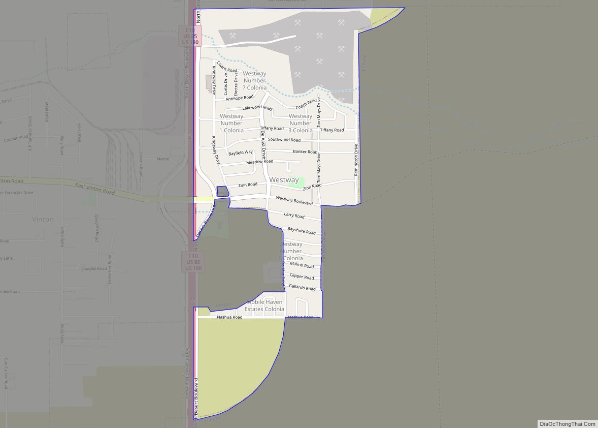
Westway is a census-designated place (CDP) in El Paso County, Texas, United States. The population was 4,188 at the 2010 census. It is part of the El Paso Metropolitan Statistical Area. It is located east of Interstate 10 about 2 miles (3 km) from the New Mexico – Texas state line. The ZIP Code encompassing the ... Read more
Map of Westway CDP
Map of Westover Hills town
Westover Hills is a town in Tarrant County, Texas, United States. The population was 682 at the 2010 census. In 2000, Westover Hills was the wealthiest location in Texas by per capita income and the 12th highest-income place in the United States. It has since been surpassed in Texas by both Piney Point Village and ... Read more
Map of Westover Hills town
Map of Weston city, Texas
Weston is a city in Collin County, Texas, United States. The population was 563 at the 2010 census, and 283 at the 2020 United States census. Weston city overview: Name: Weston city LSAD Code: 25 LSAD Description: city (suffix) State: Texas County: Collin County Elevation: 748 ft (228 m) Total Area: 4.52 sq mi (11.71 km²) Land Area: 4.49 sq mi (11.62 km²) ... Read more
Map of Weston city, Texas
Map of Weston Lakes city
Weston Lakes is a city in Fort Bend County, Texas, United States, within Greater Houston. Residents voted to incorporate the community in an election held on May 10, 2008. At the time of incorporation, there were about 2,300 residents living in Weston Lakes. The population was 3,853 as of the 2020 census. Weston Lakes city ... Read more
Map of Weston Lakes city
Map of White Oak city, Texas
White Oak is a city in Gregg County, Texas, United States. It was incorporated in 1960. The population was 6,225 as of 2020. White Oak city overview: Name: White Oak city LSAD Code: 25 LSAD Description: city (suffix) State: Texas County: Gregg County Elevation: 413 ft (126 m) Total Area: 9.14 sq mi (23.67 km²) Land Area: 9.09 sq mi (23.54 km²) Water ... Read more
Map of White Oak city, Texas
Map of White Deer town
White Deer is a town in Carson County, Texas, United States. The population was 1,000 at the 2010 census. It is part of the Amarillo metropolitan statistical area. White Deer town overview: Name: White Deer town LSAD Code: 43 LSAD Description: town (suffix) State: Texas County: Carson County Elevation: 3,366 ft (1,026 m) Total Area: 1.74 sq mi (4.51 km²) ... Read more
Map of White Deer town
Map of Wheeler city, Texas
Wheeler is a city, and the county seat of Wheeler County, Texas, United States, located on the eastern border of the Texas Panhandle. The population was last reported at 1,592 in the 2010 census. Wheeler city overview: Name: Wheeler city LSAD Code: 25 LSAD Description: city (suffix) State: Texas County: Wheeler County Elevation: 2,507 ft (764 m) ... Read more
Map of Wheeler city, Texas
Map of Wildwood CDP, Texas
Wildwood is a gated community and census-designated place in Hardin and Tyler counties, Texas, United States. As of the 2020 census it had a population of 1,121. The Hardin county portion of Wildwood is part of the Beaumont–Port Arthur Metropolitan Statistical Area. Wildwood CDP overview: Name: Wildwood CDP LSAD Code: 57 LSAD Description: CDP (suffix) ... Read more
Map of Wildwood CDP, Texas
Map of Wild Peach Village CDP
Wild Peach Village is a census-designated place (CDP) in Brazoria County, Texas, United States. The population was 2,329 at the 2020 census. Wild Peach Village CDP overview: Name: Wild Peach Village CDP LSAD Code: 57 LSAD Description: CDP (suffix) State: Texas County: Brazoria County Elevation: 26 ft (8 m) Total Area: 10.0 sq mi (25.9 km²) Land Area: 10.0 sq mi (25.9 km²) ... Read more
Map of Wild Peach Village CDP
Map of Wickett town
Wickett is a town in Ward County, Texas, United States. The population was 498 at the 2010 census. Wickett town overview: Name: Wickett town LSAD Code: 43 LSAD Description: town (suffix) State: Texas County: Ward County Elevation: 2,667 ft (813 m) Total Area: 0.70 sq mi (1.82 km²) Land Area: 0.70 sq mi (1.82 km²) Water Area: 0.00 sq mi (0.00 km²) Total Population: 498 Population ... Read more
Map of Wickett town
Map of Wichita Falls city
Wichita Falls (/ˈwɪtʃɪtɑː/ WITCH-i-tah) is a city in and the seat of government of Wichita County, Texas, United States. It is the principal city of the Wichita Falls metropolitan statistical area, which encompasses all of Archer, Clay, and Wichita counties. According to the 2010 census, it had a population of 104,553, making it the 38th-most ... Read more
Map of Wichita Falls city
Map of Whitney town, Texas
Whitney is a city in Hill County, Texas, United States. Its population was 1,992 at the 2020 census. The city is 3 miles (5 km) east of Lake Whitney. The Amazon Prime original movie The Vast of Night was shot in Whitney, which doubled for the fictional town of Cayuga, New Mexico. Whitney town overview: Name: ... Read more
Map of Whitney town, Texas