Map of Blairs CDP
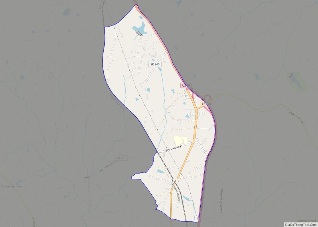
Blairs is a census-designated place (CDP) in Pittsylvania County, Virginia, United States. The population as of the 2010 Census was 916. Chatham-Blairs is also the name of a political district in south-central Pittsylvania County, Virginia. Blairs CDP overview: Name: Blairs CDP LSAD Code: 57 LSAD Description: CDP (suffix) State: Virginia County: Pittsylvania County FIPS code: ... Read more
Map of Blairs CDP
Map of Blackstone town
Blackstone, formerly named Blacks and Whites, and then Bellefonte, is a town in Nottoway County in the U.S. state of Virginia. The population was 3,621 at the 2010 census. Blackstone town overview: Name: Blackstone town LSAD Code: 43 LSAD Description: town (suffix) State: Virginia County: Nottoway County Elevation: 453 ft (138 m) Total Area: 4.51 sq mi (11.69 km²) Land ... Read more
Map of Blackstone town
Map of Boswell’s Corner CDP
Boswell’s Corner is a census-designated place in Stafford County, Virginia. The population as of the 2010 Census was 1,375. It is located along U.S. Route 1 just outside the boundary of Marine Corps Base Quantico (“Boswell’s Corner” itself is the intersection with Telegraph Road). Boswell’s Corner CDP overview: Name: Boswell’s Corner CDP LSAD Code: 57 ... Read more
Map of Boswell’s Corner CDP
Map of Boones Mill town
Boones Mill is a town in Franklin County, Virginia, United States. The population was 239 in 2018, down from 285 at the 2000 census. It is part of the Roanoke Metropolitan Statistical Area. Boones Mill town overview: Name: Boones Mill town LSAD Code: 43 LSAD Description: town (suffix) State: Virginia County: Franklin County Elevation: 1,150 ft ... Read more
Map of Boones Mill town
Map of Blue Ridge Shores CDP
Blue Ridge Shores is a census-designated place (CDP) in Louisa County, Virginia, United States. The population as of the 2010 census was 813. It was built beginning in 1960 as a resort community around Lake Louisa. Blue Ridge Shores CDP overview: Name: Blue Ridge Shores CDP LSAD Code: 57 LSAD Description: CDP (suffix) State: Virginia ... Read more
Map of Blue Ridge Shores CDP
Map of Bland CDP, Virginia
Bland is a census-designated place (CDP) in and the county seat of Bland County, Virginia, United States. Bland was originally known as Bland Court House. The population as of the 2020 Census was 312. Bland CDP overview: Name: Bland CDP LSAD Code: 57 LSAD Description: CDP (suffix) State: Virginia County: Bland County Elevation: 2,438 ft (743 m) ... Read more
Map of Bland CDP, Virginia
Map of Boykins town
Boykins is a town in Southampton County, Virginia, United States. The population was 564 at the 2010 census. Boykins town overview: Name: Boykins town LSAD Code: 43 LSAD Description: town (suffix) State: Virginia County: Southampton County Elevation: 39 ft (12 m) Total Area: 0.69 sq mi (1.80 km²) Land Area: 0.69 sq mi (1.80 km²) Water Area: 0.00 sq mi (0.00 km²) Total Population: 564 Population ... Read more
Map of Boykins town
Map of Boydton town
Boydton is a town in Mecklenburg County, Virginia, United States. The population was 431 at the 2010 census. It is the county seat of Mecklenburg County, and it is near Kerr Lake. Boydton town overview: Name: Boydton town LSAD Code: 43 LSAD Description: town (suffix) State: Virginia County: Mecklenburg County Elevation: 354 ft (108 m) Total Area: ... Read more
Map of Boydton town
Map of Boyce town, Virginia
Boyce is a town in Clarke County, Virginia, United States. The population was 749 at the 2020 census, up from 589 at the 2010 census. Boyce town overview: Name: Boyce town LSAD Code: 43 LSAD Description: town (suffix) State: Virginia County: Clarke County Elevation: 597 ft (182 m) Total Area: 0.37 sq mi (0.95 km²) Land Area: 0.37 sq mi (0.95 km²) Water ... Read more
Map of Boyce town, Virginia
Map of Brightwood CDP
Brightwood is a census-designated place (CDP) in Madison County, Virginia. Its ZIP Code is 22715. The population as of the 2020 Census was 1,064. Brightwood CDP overview: Name: Brightwood CDP LSAD Code: 57 LSAD Description: CDP (suffix) State: Virginia County: Madison County FIPS code: 5109752 Online Interactive Map Brightwood online map. Source: Basemap layers from ... Read more
Map of Brightwood CDP
Map of Brandermill CDP
Brandermill is a major suburban residential and commercial development in the Southside of Richmond, Virginia. It is located near Midlothian, Virginia at the southern terminus of the Powhite Parkway and is centered on the Swift Creek Reservoir. The Census Bureau defines it as a Census-designated place (CDP), with a population of 13,173 as of the ... Read more
Map of Brandermill CDP
Map of Branchville town, Virginia
Branchville is a town in Southampton County, Virginia, United States. The population was 123 at the 2000 census. Branchville town overview: Name: Branchville town LSAD Code: 43 LSAD Description: town (suffix) State: Virginia County: Southampton County Elevation: 43 ft (13 m) Total Area: 0.43 sq mi (1.11 km²) Land Area: 0.43 sq mi (1.11 km²) Water Area: 0.00 sq mi (0.00 km²) Total Population: 114 Population ... Read more
Map of Branchville town, Virginia